Aiglun, Alpes-Maritimes
| Aiglun | ||
|---|---|---|
|
A general view of the village | ||
| ||
 Aiglun | ||
|
Location within Provence-A.-C.d'A. region 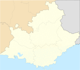 Aiglun | ||
| Coordinates: 43°51′30″N 6°54′54″E / 43.8583°N 6.915°ECoordinates: 43°51′30″N 6°54′54″E / 43.8583°N 6.915°E | ||
| Country | France | |
| Region | Provence-Alpes-Côte d'Azur | |
| Department | Alpes-Maritimes | |
| Arrondissement | Grasse | |
| Canton | Saint-Auban | |
| Intercommunality | Monts d'Azur | |
| Government | ||
| • Mayor (2014–2020) | Didier Nicolas | |
| Area1 | 15.37 km2 (5.93 sq mi) | |
| Population (2009)2 | 91 | |
| • Density | 5.9/km2 (15/sq mi) | |
| Time zone | CET (UTC+1) | |
| • Summer (DST) | CEST (UTC+2) | |
| INSEE/Postal code | 06001 / 06910 | |
| Elevation |
373–1,541 m (1,224–5,056 ft) (avg. 624 m or 2,047 ft) | |
|
1 French Land Register data, which excludes lakes, ponds, glaciers > 1 km² (0.386 sq mi or 247 acres) and river estuaries. 2 Population without double counting: residents of multiple communes (e.g., students and military personnel) only counted once. | ||
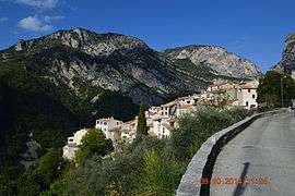
Aiglun is a French commune in the Alpes-Maritimes department in the Provence-Alpes-Côte d'Azur region of southeastern France.
The inhabitants of the commune are known as Aiglenois or Aiglenoises.[1]
Geography
Aiglun is a remote mountain commune some 40 km north-east of Nice in a straight line. There are only two access routes to the commune - the first by Highway D17 from Roquesteron to the east. Heading west on Highway D17 continue left onto Highway D10 which continues via a mountainous route into the commune and the village of Aiglun. The other access is the continuation of Highway D10 west from Aiglun over a circuitous mountain route to Le Mas. The Estéron river passes through the commune south of the village and forms part of the western border of the commune as well as a small portion of the eastern border. Numerous streams feed into this river in the commune.
The northern part of the commune consists of high snow-capped mountains while the southern part is less high mountains. There are few roads however there are four hamlets in the Esteron Valley: Vascogne, Les Lones, Le Colombier, and L'Escle.[2]
Neighbouring Communes and Villages
 |
Val-de-Chavagne | Puget-Theniers | La Pen | |
| Le Mas | |
Sigale | ||
| ||||
| | ||||
| Andon | Gréolières | Coursegoules |
History
In 1388 the village of Aiglun was under the protection of the House of Savoy like the rest of the region during the "Dédition of Nice to Savoy"[3] from 1388.
At the Treaty of Turin on 24 March 1760, the commune became French (the kingdom of France and that of Sardinia then proceeded to boundary adjustments and therefore there was an exchange of territories).
Toponymy
The name of the town appears for the first time in texts around 1200 in the form Ayglezuni. This was derived from the Latin word Aquila, meaning "eagle", and the Gallic dunum, meaning "height" and signifies as a whole the "height of the eagle".[4]
Heraldry
 |
Blazon: Azure, a spread eagle of Argent over a salmon the same. |
Administration
List of Successive Mayors of Aiglun[5]
| From | To | Name | Party | Position |
|---|---|---|---|---|
| 1870 | 1874 | Jean-Baptiste GRANIER | ||
| 1874 | 1876 | Antoine BERNARD | ||
| 1876 | 1878 | Louis BERNARD | ||
| 1878 | 1881 | Auguste BONNEFROI | ||
| 1881 | 1884 | Désiré MARTEL | ||
| 1884 | 1888 | Joseph DAUMAS | ||
| 1888 | 1896 | Désiré MARTEL | ||
| 1896 | 1900 | Jean-Pierre JAUME | ||
| 1900 | 1901 | Pierre GUIZOL | ||
| 1901 | 1912 | Joseph ROBIN | ||
| 1912 | 1920 | Jean-Pierre JAUME | ||
| 1920 | 1942 | Antoine ROUX |

- Mayors from 1942
| From | To | Name | Party | Position |
|---|---|---|---|---|
| 1942 | 1945 | François BLANC | ||
| 1945 | 1978 | Pierre MARTIN | ||
| 1978 | 2001 | Marius BLANC | ||
| 2001 | 2005 | Irene Montiglio | SE | |
| 2005 | 2014 | Charles Bremond | DVD | |
| 2014 | 2020 | Didier Nicolas |
(Not all data is known)
Demography
In 2009 the commune had 91 inhabitants. The evolution of the number of inhabitants is known through the population censuses conducted in the town since 1793. From the 21st century, a census of municipalities with fewer than 10,000 inhabitants is held every five years, unlike larger towns that have a sample survey every year.[Note 1] [Note 2]
| 1793 | 1800 | 1806 | 1821 | 1831 | 1836 | 1841 | 1846 | 1851 |
|---|---|---|---|---|---|---|---|---|
| 240 | 203 | 261 | 250 | 266 | 248 | 351 | 366 | 380 |
| 1856 | 1861 | 1866 | 1872 | 1876 | 1881 | 1886 | 1891 | 1896 |
|---|---|---|---|---|---|---|---|---|
| 344 | 286 | 286 | 272 | 268 | 218 | 187 | 241 | 175 |
| 1901 | 1906 | 1911 | 1921 | 1926 | 1931 | 1936 | 1946 | 1954 |
|---|---|---|---|---|---|---|---|---|
| 150 | 152 | 142 | 100 | 115 | 110 | 123 | 95 | 90 |
| 1962 | 1968 | 1975 | 1982 | 1990 | 1999 | 2009 | - | - |
|---|---|---|---|---|---|---|---|---|
| 58 | 50 | 70 | 94 | 91 | 106 | 91 | - | - |
Sources : Ldh/EHESS/Cassini until 1962, INSEE database from 1968 (population without double counting and municipal population from 2006)


Sites and Monuments
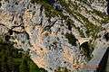
The village is known for its steep climbing walls over 200 metres high with high difficulty routes. The Aiglun canyon is also popular for canyoning enthusiasts.
Aiglun Picture Gallery
-
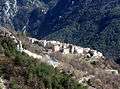
The Village
-
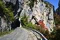
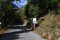
First tunnel on the road to the village
-
The bridge entering Aiglun
-
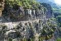
The cliff road into Aiglun
-
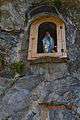
An Oratory in the cliff face
-
The entry to Aiglun
-
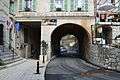
Main entrance to Aiglun
-
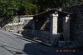
Aiglun Water Trough
-
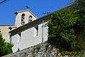
Aiglun Church
Notable People linked to the commune
- Fanny Robiane. Daughter of Joseph Robin, who was mayor of Aiglun in the early 20th century, this French theatre actress died in 1982 at Aiglun, where she retired and she has left a rich archive (autographed books, including by Armand Godoy, Jean-Richard Bloch and others; pictures; clippings, etc.). Her memory is still alive with the people of Aiglun (the Aiglenois) who knew her and plans are underway to honour her. A cultural association sponsored among others by the commune and the General Council launched since 2004 called "Fanny Robiane Encounter" devoted to theatre, poetry, music and other one-time cultural events are scheduled throughout the year. Sometimes these events are carried out in collaboration with the University of Nice.
See also
- Communes of the Alpes-Maritimes department
- Yves Bernard, The Tourist and Cultural Directory of the Alpes-Maritimes and Monaco, p. 149 Publishing Campanile, 1997 (ISBN 978-2-912366-00-9)
Notes and references
Notes
- ↑ At the beginning of the 21st century, the methods of identification have been modified by law No. 2002-276 of 27 February 2002 , the so-called "law of local democracy" and in particular Title V "census operations" which allow, after a transitional period running from 2004 to 2008, the annual publication of the legal population of the different French administrative districts. For municipalities with a population greater than 10,000 inhabitants, a sample survey is conducted annually, the entire territory of these municipalities is taken into account at the end of the period of five years. The first "legal population" after 1999 under this new law came into force on 1 January 2009 and was based on the census of 2006.
- ↑ In the census table and the graph, by convention in Wikipedia, and to allow a fair comparison between five yearly censuses, the principle has been retained for subsequent legal populations since 1999 displayed in the census table and the graph that shows populations for the years 2006, 2011, 2016, etc., as well as the latest legal population published by INSEE
References
- ↑ Inhabitants of Alpes-Maritimes (French)
- ↑ Google Maps
- ↑ This was a charter of 28 September 1388 which attached Nice to the new territories of Provence for the House of Savoy. See Dédition de Nice à la Savoie in the French Wikipedia
- ↑ Ernest Nègre, Toponymie générale de la France: etymology of 35,000 place names, Genève: Librairie Droz, 1990. Collection of Roman and French Publications, volume 193. Volume I : Preceltic, Celtic, and Roman words, § 2725, p. 173,
- ↑ List of Mayors of France
External links
| Wikimedia Commons has media related to Aiglun, Alpes-Maritimes. |
- Official website for Aiglun (French)
- Aiglun on the old IGN website (French)
- Aiglun on Lion1906
- Aiglun on Google Maps
- Aiglun on Géoportail, National Geographic Institute (IGN) website (French)
- Aiglun on the 1750 Cassini Map
- Aiglun on the INSEE website (French)
- INSEE (French)