Alstahaug
| Alstahaug kommune | |||
|---|---|---|---|
| Municipality | |||
|
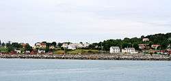
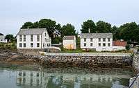
Village of Tjøtta in Alstahaug | |||
| |||
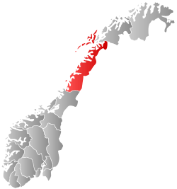
 Alstahaug within Nordland | |||
| Coordinates: 65°57′24″N 12°34′22″E / 65.95667°N 12.57278°ECoordinates: 65°57′24″N 12°34′22″E / 65.95667°N 12.57278°E | |||
| Country | Norway | ||
| County | Nordland | ||
| District | Helgeland | ||
| Administrative centre | Sandnessjøen | ||
| Government | |||
| • Mayor (2011) | Bård Anders Langø (Ap) | ||
| Area | |||
| • Total | 187.22 km2 (72.29 sq mi) | ||
| • Land | 186.29 km2 (71.93 sq mi) | ||
| • Water | 0.93 km2 (0.36 sq mi) | ||
| Area rank | 336 in Norway | ||
| Population (2011) | |||
| • Total | 7,296 | ||
| • Rank | 134 in Norway | ||
| • Density | 39.2/km2 (102/sq mi) | ||
| • Change (10 years) | -1.5 % | ||
| Demonym(s) | Alstahaugværing[1] | ||
| Time zone | CET (UTC+1) | ||
| • Summer (DST) | CEST (UTC+2) | ||
| ISO 3166 code | NO-1820 | ||
| Official language form | Neutral | ||
| Website |
www | ||
|
| |||

Alstahaug is a municipality in Nordland county, Norway. It is part of the Helgeland region. The administrative centre of the municipality is the town of Sandnessjøen. Other villages in Alstahaug include Søvika and Tjøtta.

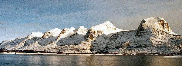
The administrative centre of Alstahaug is the town Sandnessjøen which is situated on the island of Alsta. The characteristic Seven Sisters mountain range is found on the eastern part of the island. Local legend has made this chain of peaks into seven sisters, two adjacent peaks representing twin sisters.
The island is connected to the mainland via the impressive Helgeland Bridge along Norwegian County Road 17. The Sandnessjøen Airport, Stokka is located just south of Sandnessjøen.
General information
Alstahaug was established as a municipality on 1 January 1838 (see formannskapsdistrikt). In 1862, the southern district (population: 2,781) was separated to become the new municipality of Tjøtta (Vevelstad was later separated from Tjøtta). In 1864, the western island district (population: 2,438) was separated to become the new municipality of Herøy. Then on 1 July 1899, the northern district (population: 2,673) was separated to form the new municipality of Stamnes (Leirfjord was later separated from Stamnes).
On 1 January 1965, the Husvær area of Alstahaug (population: 461) was transferred from Alstahaug to Herøy. On the same day, the municipalities of Tjøtta (not including the Skogsholmen area), Sandnessjøen, and the rest of Alstahaug were all merged to form the new, larger municipality of Alstahaug. On 1 January 1971, the Skålvær islands (population: 32) were transferred from Vega to Alstahaug. On 1 January 1995, the mainland areas of Alstahaug (population: 70) were transferred to Vefsn.[2]
Name
The municipality (originally the parish) is named after the old Alstahaug farm (Old Norse: Alastarhaugr), since the first church was built there. The first element is the genitive case of the name of the island Alöst (now Alsta) and the last element is haugr which means "hill" or "mound".[3]
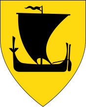
Coat-of-arms
The coat-of-arms is from modern times; they were granted on 8 August 1986. The arms show the Seven Sisters (Norwegian: De syv søstre), a row of mountains in the area, mirrored in the clear waters of the fjord.[4]
Churches
The Church of Norway has three parishes (sokn) within the municipality of Alstahaug. It is part of the Nord-Helgeland deanery in the Diocese of Sør-Hålogaland.
| Parish (Sokn) | Church Name | Location of the Church | Year Built |
|---|---|---|---|
| Alstahaug | Alstahaug Church | Alstahaug | 12th century |
| Sandnessjøen | Sandnessjøen Church | Sandnessjøen | 1882 |
| Tjøtta | Skålvær Church | Skålvær | 1851 |
| Tjøtta Church | Tjøtta | 1867 |
History
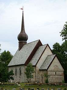
At Alstahaug, on the southern end of the island of Alsta, lies the medieval Alstahaug Church, where the poet and minister Petter Dass worked around 1700. Tjøtta, an island south of Alsta, is the place where the famous Viking Hårek resided in the 11th century.
Nature
Birdlife
Lying just south of the Arctic Circle in an area that is known as Outer Helgeland, Alstahaug offers the visiting bird watcher a chance to do some birding in spectacular scenery, be it coastal or inland where The Seven Sisters mountain chain marks the boundary between the habitats. One of the better areas to birdwatch is Tjøtta. Here you will find the small nature reserve Ostjønna.
Geography
Alstahaug is a municipality consisting entirely of islands. Most residents live on the main islands of Alsta and Tjøtta, and Alstahaug stretches from the Skålvær island group in the west, to the Vefsnfjorden in the east, and to Mindlandet island to the south. The municipalities of Leirfjord, Vefsn, and Vevelstad lie to the east and Dønna, Herøy, and Vega.
Climate
Alstahaug has an oceanic climate. February is often the coldest month, and August is often the warmest. October is almost as warm as May. The mean annual precipitation is 1,510 millimetres (59 in) at Sandnessjøen and 1,020 millimetres (40 in) at Tjøtta. The wettest period is from September to January with approximately 150 millimetres (5.9 in) each month, while in May and June it averages 60 to 70 millimetres (2.4 to 2.8 in) each month.[5]
| Climate data for Sandnessjøen (10 last years) | |||||||||||||
|---|---|---|---|---|---|---|---|---|---|---|---|---|---|
| Month | Jan | Feb | Mar | Apr | May | Jun | Jul | Aug | Sep | Oct | Nov | Dec | Year |
| Average high °C (°F) | 2 (36) |
−1 (30) |
1 (34) |
6 (43) |
11 (52) |
12 (54) |
15 (59) |
15 (59) |
13 (55) |
10 (50) |
7 (45) |
4 (39) |
7.9 (46.3) |
| Average low °C (°F) | 0 (32) |
−4 (25) |
−2 (28) |
2 (36) |
7 (45) |
8 (46) |
11 (52) |
12 (54) |
10 (50) |
7 (45) |
4 (39) |
1 (34) |
4.7 (40.5) |
| Source: [6] | |||||||||||||
Government
All municipalities in Norway, including Alstahaug, are responsible for primary education (through 10th grade), outpatient health services, senior citizen services, unemployment and other social services, zoning, economic development, and municipal roads. The municipality is governed by a municipal council of elected representatives, which in turn elect a mayor.
Municipal council
The municipal council (Kommunestyre) of Alstahaug is made up of 27 representatives that are elected to every four years. Currently, the party breakdown is as follows:[7]
| Party Name | Name in Norwegian | Number of representatives | |
|---|---|---|---|
| Labour Party | Arbeiderpartiet | 11 | |
| Progress Party | Fremskrittspartiet | 2 | |
| Conservative Party | Høyre | 4 | |
| Red Party | Rødt | 2 | |
| Centre Party | Senterpartiet | 5 | |
| Socialist Left Party | Sosialistisk Venstreparti | 1 | |
| Liberal Party | Venstre | 2 | |
| Total number of members: | 27 | ||
References
- ↑ "Navn på steder og personer: Innbyggjarnamn" (in Norwegian). Språkrådet. Retrieved 2015-12-01.
- ↑ Jukvam, Dag (1999). "Historisk oversikt over endringer i kommune- og fylkesinndelingen" (PDF) (in Norwegian). Statistisk sentralbyrå.
- ↑ Rygh, Oluf (1905). Norske gaardnavne: Nordlands amt (in Norwegian) (16 ed.). Kristiania, Norge: W. C. Fabritius & sønners bogtrikkeri. p. 89.
- ↑ Norske Kommunevåpen (1990). "Nye kommunevåbener i Norden". Retrieved 18 November 2008.
- ↑ Alstahaug climate statistics
- ↑ "Sandnessjøen average conditions; base period 10 last years". Storm Weather Center. Retrieved 5 December 2009.
- ↑ "Table: 04813: Members of the local councils, by party/electoral list at the Municipal Council election (M)" (in Norwegian). Statistics Norway. 2015.
External links
| Wikimedia Commons has media related to Alstahaug. |
 Nordland travel guide from Wikivoyage
- Municipal fact sheet from Statistics Norway
- Picture: Beach south of Sandnessjøen
- Summer picture with the mountains in the background
- Skeilia nature reserve (Norwegian)