Hadsel
| Hadsel kommune | |||
|---|---|---|---|
| Municipality | |||
 | |||
| |||
 Hadsel within Nordland | |||
| Coordinates: 68°32′6″N 14°49′30″E / 68.53500°N 14.82500°ECoordinates: 68°32′6″N 14°49′30″E / 68.53500°N 14.82500°E | |||
| Country | Norway | ||
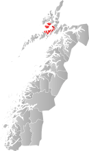
| County | Nordland | ||
| District | Vesterålen | ||
| Administrative centre | Stokmarknes | ||
| Government | |||
| • Mayor (2007) | Kjell Børge Freiberg (FrP) | ||
| Area | |||
| • Total | 566.44 km2 (218.70 sq mi) | ||
| • Land | 551.12 km2 (212.79 sq mi) | ||
| • Water | 15.32 km2 (5.92 sq mi) | ||
| Area rank | 188 in Norway | ||
| Population (2012) | |||
| • Total | 7,937 | ||
| • Rank | 129 in Norway | ||
| • Density | 14.4/km2 (37/sq mi) | ||
| • Change (10 years) | -2.4 % | ||
| Demonym(s) | Hadselværing[1] | ||
| Time zone | CET (UTC+1) | ||
| • Summer (DST) | CEST (UTC+2) | ||
| ISO 3166 code | NO-1866 | ||
| Official language form | Bokmål | ||
| Website |
www | ||
|
| |||

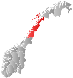
Hadsel (Northern Sami: Válafierda) is a municipality in Nordland county, Norway. It is part of the traditional district of Vesterålen. The administrative centre of the municipality is the town of Stokmarknes. Other villages in Hadsel include Fiskebøl, Gjerstad, Grønning, Grytting, Hanøyvika, Hennes, Kaljord, Melbu, Sanden, and Sandnes.
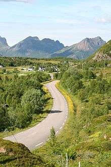

The municipality is the southernmost municipality in the Vesterålen region. It is spread over four islands: Hadseløya, Hinnøya, Langøya, and Austvågøya. About 70% of the population live on Hadseløya island. Hadseløya island is connected to Langøya by the Hadsel Bridge and Børøy Bridge. Also, the Stokmarknes Airport, Skagen, is located nearby. It is the busiest small aircraft airport in Norway, serving 100,000 passengers annually (1997).
The municipality of Sortland lies to the north, Bø to the west, Vågan to the south, and Lødingen to the east.
History
Hadsel was established as a municipality on 1 January 1838 (see formannskapsdistrikt). The northern district of Hadsel was separated in 1841 to form the new municipality of Sortland. On 1 January 1963, the Indre Eidsfjord district of Hadsel (population: 1,360) was transferred to Sortland municipality.[2]
Name
The municipality (originally the parish) is named after the old Hadsel farm (Old Norse: Hǫfðasegl), since the first church (Hadsel Church) was built there. The first element is the genitive case of hǫfði which means "high and steep cliff" and the last element is segl which means "sail". (A cliff near the farm has been compared in form to a sail.)[3]
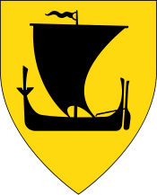
Coat-of-arms
The coat-of-arms is from modern times. They were granted on 11 March 1976. The arms show four golden rings on a blue background. This design represents the four islands of that make up Hadsel: Hadseløya, Austvågøya, Hinnøya, and Langøya.[4]
Churches
The Church of Norway has three parishes (sokn) within the municipality of Hadsel. It is part of the Vesterålen deanery in the Diocese of Sør-Hålogaland.
| Parish (Sokn) | Church Name | Location of the Church | Year Built |
|---|---|---|---|
| Hadsel | Hadsel Church | Hadsel | 1824 |
| Innlandet Church | Hennes | 1992 | |
| Melbu | Melbu Church | Melbu | 1938 |
| Sand Church | Sanden | 1914 | |
| Ytre Eidsfjord | Grønning Church | Grønning | 1968 |
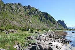
Geography
The municipality is located upon four islands in the Vesterålen archipelago: Hinnøya, Langøya, Hadseløya, and Austvågøya. The mountain Higravstinden on the border with Vågan is one of the tallest mountains in the region.
Climate
| Climate data for Melbu, Hadsel | |||||||||||||
|---|---|---|---|---|---|---|---|---|---|---|---|---|---|
| Month | Jan | Feb | Mar | Apr | May | Jun | Jul | Aug | Sep | Oct | Nov | Dec | Year |
| Daily mean °C (°F) | −1.4 (29.5) |
−1.5 (29.3) |
−0.6 (30.9) |
1.9 (35.4) |
6.3 (43.3) |
9.7 (49.5) |
12.1 (53.8) |
12.0 (53.6) |
8.6 (47.5) |
5.0 (41) |
1.6 (34.9) |
−0.6 (30.9) |
4.4 (39.9) |
| Average precipitation mm (inches) | 110 (4.33) |
95 (3.74) |
83 (3.27) |
69 (2.72) |
49 (1.93) |
50 (1.97) |
65 (2.56) |
68 (2.68) |
107 (4.21) |
155 (6.1) |
123 (4.84) |
126 (4.96) |
1,100 (43.31) |
| Source: Norwegian Meteorological Institute[5] | |||||||||||||
Government
All municipalities in Norway, including Hadsel, are responsible for primary education (through 10th grade), outpatient health services, senior citizen services, unemployment and other social services, zoning, economic development, and municipal roads. The municipality is governed by a municipal council of elected representatives, which in turn elect a mayor.
Municipal council
The municipal council (Kommunestyre) of Hadsel is made up of 25 representatives that are elected to every four years. Currently, the party breakdown is as follows:[6]
| Party Name | Name in Norwegian | Number of representatives | |
|---|---|---|---|
| Labour Party | Arbeiderpartiet | 11 | |
| Progress Party | Fremskrittspartiet | 5 | |
| Conservative Party | Høyre | 2 | |
| Red Party | Rødt | 1 | |
| Centre Party | Senterpartiet | 3 | |
| Socialist Left Party | Sosialistisk Venstreparti | 1 | |
| Liberal Party | Venstre | 1 | |
| Local Lists | Lokale lister | 1 | |
| Total number of members: | 25 | ||
References
- ↑ "Navn på steder og personer: Innbyggjarnamn" (in Norwegian). Språkrådet. Retrieved 2015-12-01.
- ↑ Jukvam, Dag (1999). "Historisk oversikt over endringer i kommune- og fylkesinndelingen" (PDF) (in Norwegian). Statistisk sentralbyrå.
- ↑ Rygh, Oluf (1905). Norske gaardnavne: Nordlands amt (in Norwegian) (16 ed.). Kristiania, Norge: W. C. Fabritius & sønners bogtrikkeri. p. 363.
- ↑ Norske Kommunevåpen (1990). "Nye kommunevåbener i Norden". Retrieved 2008-11-20.
- ↑ "eKlima Web Portal". Norwegian Meteorological Institute.
- ↑ "Table: 04813: Members of the local councils, by party/electoral list at the Municipal Council election (M)" (in Norwegian). Statistics Norway. 2015.
External links
| Wikimedia Commons has media related to Hadsel. |
 Nordland travel guide from Wikivoyage
- Municipal fact sheet from Statistics Norway
- Pictures from Hadsel