Lurøy
| Lurøy kommune | |||
|---|---|---|---|
| Municipality | |||
 | |||
| |||
 Lurøy within Nordland | |||
| Coordinates: 66°25′55″N 12°51′18″E / 66.43194°N 12.85500°ECoordinates: 66°25′55″N 12°51′18″E / 66.43194°N 12.85500°E | |||
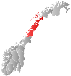
| Country | Norway | ||
| County | Nordland | ||
| District | Helgeland | ||
| Administrative centre | Lurøy | ||
| Government | |||
| • Mayor (2011) | Bjørnar Skjæran (Ap) | ||
| Area | |||
| • Total | 264.55 km2 (102.14 sq mi) | ||
| • Land | 257.63 km2 (99.47 sq mi) | ||
| • Water | 6.92 km2 (2.67 sq mi) | ||
| Area rank | 291 in Norway | ||
| Population (2011) | |||
| • Total | 1,912 | ||
| • Rank | 337 in Norway | ||
| • Density | 7.4/km2 (19/sq mi) | ||
| • Change (10 years) | -9.6 % | ||
| Demonym(s) | Lurøyværing[1] | ||
| Time zone | CET (UTC+1) | ||
| • Summer (DST) | CEST (UTC+2) | ||
| ISO 3166 code | NO-1834 | ||
| Official language form | Bokmål | ||
| Website |
www | ||
|
| |||

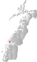
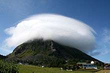
Lurøy is a municipality in Nordland county, Norway. It is part of the Helgeland traditional region. The administrative centre of the municipality is the village of Lurøy, located on the island of Lurøya. Other villages include Aldra, Haugland, Konsvikosen, Lovund, Sleneset, Stokkvågen, and Tonnes.
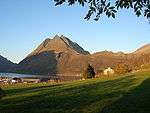
The municipality is located on the coast just south of the Arctic circle, on the western edge of the Saltfjellet mountain range. The Lurøygården (Lurøy Farm) on Lurøya is a more-than-200-year-old renaissance garden with old plants, a pool, and a nearly 20-metre (66 ft) high Copper Beech.
General information
Lurøy was established as a municipality on 1 January 1838 (see formannskapsdistrikt). On 1 January 1872, the far western island district (population: 289) was separated from Lurøy to become the new municipality of Træna. This left Lurøy with 1,554 residents. The borders of Lurøy have not changed since that time.[2]
Name
The municipality (originally the parish) is named after the island of Lurøya (Old Norse: Lúðrøy), since the first church was built there. The first element is lúðr which means "hollowed log" (here probably referring to the form of the mountain of the island). The last element is øy which means "island".[3]
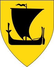
Coat-of-arms
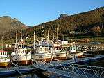
The coat-of-arms is from modern times; they were granted on 22 August 1986. The arms show a black buoy on a gold background. The buoy is an appropriate symbol for a municipality since it is dependent on fishing and sailing.[4]
Churches
The Church of Norway has two parishes (sokn) within the municipality of Lurøy. It is part of the Nord-Helgeland deanery in the Diocese of Sør-Hålogaland.
| Parish (Sokn) | Church Name | Location of the Church | Year Built |
|---|---|---|---|
| Aldersund | Aldersund Church | Haugland | 1971 |
| Lurøy | Lovund Church | Lovund | 1960 |
| Lurøy Church | Lurøya | 1812 | |
| Moflag Church | Moflaget | 1921 |
Geography
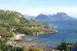
Lurøy is located on the western coast of Helgeland. The small strip of mainland Lurøy runs from Tonnes in the north along Norwegian County Road 17 to Stokkvågen along the Sjona fjord in the south. The rest of the municipality is located on 1,375 islands located to the west of the mainland. The major islands include Aldra, Lurøya, Onøya, Stigen, Solvær, and Lovund. There are also two islands in the northern part of Lurøya that are divided between Lurøy and neighboring Rødøy municipality: Nesøya and Hestmona.[5]
Government
All municipalities in Norway, including Lurøy, are responsible for primary education (through 10th grade), outpatient health services, senior citizen services, unemployment and other social services, zoning, economic development, and municipal roads. The municipality is governed by a municipal council of elected representatives, which in turn elect a mayor.
Municipal council
The municipal council (Kommunestyre) of Lurøy is made up of 19 representatives that are elected to every four years. Currently, the party breakdown is as follows:[6]
| Party Name | Name in Norwegian | Number of representatives | |
|---|---|---|---|
| Labour Party | Arbeiderpartiet | 6 | |
| Progress Party | Fremskrittspartiet | 1 | |
| Conservative Party | Høyre | 2 | |
| Christian Democratic Party | Kristelig Folkeparti | 1 | |
| Centre Party | Senterpartiet | 6 | |
| Local Lists | Lokale lister | 3 | |
| Total number of members: | 19 | ||
Media gallery
- Views around Lurøy
 Aldersundet strait and Aldra island; October 8, 2005
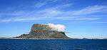
 Aldersundet, October 2005
References
- ↑ "Navn på steder og personer: Innbyggjarnamn" (in Norwegian). Språkrådet. Retrieved 2015-12-01.
- ↑ Jukvam, Dag (1999). "Historisk oversikt over endringer i kommune- og fylkesinndelingen" (PDF) (in Norwegian). Statistisk sentralbyrå.
- ↑ Rygh, Oluf (1905). Norske gaardnavne: Nordlands amt (in Norwegian) (16 ed.). Kristiania, Norge: W. C. Fabritius & sønners bogtrikkeri. pp. 154, 156.
- ↑ Norske Kommunevåpen (1990). "Nye kommunevåbener i Norden". Retrieved 2008-11-23.
- ↑ Store norske leksikon. "Lurøy" (in Norwegian). Retrieved 2012-01-30.
- ↑ "Table: 04813: Members of the local councils, by party/electoral list at the Municipal Council election (M)" (in Norwegian). Statistics Norway. 2015.
External links
| Wikimedia Commons has media related to Lurøy. |
 Nordland travel guide from Wikivoyage
- Municipal fact sheet from Statistics Norway