Vågan
| Vågan kommune Vuogát | |||
|---|---|---|---|
| Municipality | |||
 | |||
| |||
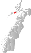 Vågan within Nordland | |||
| Coordinates: 68°16′41″N 14°31′15″E / 68.27806°N 14.52083°ECoordinates: 68°16′41″N 14°31′15″E / 68.27806°N 14.52083°E | |||
| Country | Norway | ||
| County | Nordland | ||
| District | Lofoten | ||
| Administrative centre | Svolvær | ||
| Government | |||
| • Mayor (2011) | Eivind Holst (H) | ||
| Area | |||
| • Total | 477.71 km2 (184.44 sq mi) | ||
| • Land | 459.17 km2 (177.29 sq mi) | ||
| • Water | 18.54 km2 (7.16 sq mi) | ||
| Area rank | 212 in Norway | ||
| Population (2012) | |||
| • Total | 9,086 | ||
| • Rank | 115 in Norway | ||
| • Density | 19.8/km2 (51/sq mi) | ||
| • Change (10 years) | -0.9 % | ||
| Demonym(s) | Vågaværing[1] | ||
| Time zone | CET (UTC+1) | ||
| • Summer (DST) | CEST (UTC+2) | ||
| ISO 3166 code | NO-1865 | ||
| Official language form | Neutral | ||
| Website |
www | ||
|
| |||

Vågan (Northern Sami: Vuogát) is a municipality in Nordland county, Norway. It is part of the traditional district of Lofoten. The administrative centre of the municipality is the town of Svolvær. Some of the villages in Vågan include Digermulen, Gimsøy, Gravermarka, Henningsvær, Hopen, Kabelvåg, Kleppstad, Laupstad, Liland, Skrova, Straumnes, and Sydalen.[2]
General information
Vågan was established as a municipality on 1 January 1838 (see formannskapsdistrikt). In 1856, the northwestern part of Vågan (population: 987) was separated to form the new municipality of Gimsøy. On 1 July 1918, the town of Svolvær (population: 2,429) was separated to form its own municipality. This left Vågan with 3,399 residents. On 1 January 1964, the municipalities of Gimsøy, Svolvær, and Vågan were merged to form the new, larger municipality of Vågan.[3]
Name
The municipality (originally the parish) is named after the old Vågan farm (Old Norse: Vágar), since the first church (Vågan Church) was built there. The name is the plural form of vág which means "bay". The island of Austvågøya (Old Norse: Vágøy) was named after this important site (which later led the neighboring island to be named Vestvågøya). The name was historically spelled Vaagan.[4]
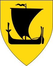
Coat of arms
The coat-of-arms is from modern times. They were granted on 30 March 1973. The arms show a white colored cod on a blue background. This was chosen because fishing is the main source of income for the municipality. The cod was also part of the older arms of the town/municipality of Svolvær.[5]
Churches
The Church of Norway has five parishes (sokn) within the municipality of Vågan. It is part of the Lofoten deanery in the Diocese of Sør-Hålogaland.
| Parish (Sokn) | Church Name | Location of the Church | Year Built |
|---|---|---|---|
| Gimsøy og Strauman | Gimsøy Church | Gimsøy | 1876 |
| Strauman Church | Sydalen | 1984 | |
| Henningsvær | Henningsvær Church | Henningsvær | 1974 |
| Strandlandet | Strandlandet Church | Straumnes | 1938 |
| Svolvær | Digermulen Church | Digermulen | 1951 |
| Sildpollnes Church | Sildpollneset | 1891 | |
| Svolvær Church | Svolvær | 1934 | |
| Vågan | Vågan Church | Kabelvåg | 1898 |
Geography
The main population centres are the town of Svolvær and the villages of Kabelvåg and Henningsvær, located on the largest island, Austvågøya (although Svolvær and Henningsvær are partly located on smaller islands adjacent to the main island). All three have a picturesque situation under the rugged Lofoten mountains, facing the rough body of water called Vestfjorden. Vågan municipality includes over half of Austvågøya island, all of the islands of Gimsøya, Skrova, Store Molla, Lille Molla, numerous other tiny islets, plus the southwestern tip of the island of Hinnøya. The Moholmen Lighthouse and Skrova Lighthouse are both located in the Vestfjorden. Two notable mountains in the municipality are Higravstinden and Svolværgeita.
Climate
| Climate data for Svolvær, Vågan | |||||||||||||
|---|---|---|---|---|---|---|---|---|---|---|---|---|---|
| Month | Jan | Feb | Mar | Apr | May | Jun | Jul | Aug | Sep | Oct | Nov | Dec | Year |
| Daily mean °C (°F) | −1.5 (29.3) |
−1.8 (28.8) |
−0.3 (31.5) |
2.2 (36) |
6.5 (43.7) |
10.1 (50.2) |
13.0 (55.4) |
13.0 (55.4) |
9.0 (48.2) |
5.2 (41.4) |
1.8 (35.2) |
−0.5 (31.1) |
4.7 (40.5) |
| Average precipitation mm (inches) | 159 (6.26) |
134 (5.28) |
112 (4.41) |
88 (3.46) |
63 (2.48) |
67 (2.64) |
87 (3.43) |
94 (3.7) |
146 (5.75) |
210 (8.27) |
160 (6.3) |
180 (7.09) |
1,500 (59.06) |
| Source: Norwegian Meteorological Institute[6] | |||||||||||||
Government
All municipalities in Norway, including Vågan, are responsible for primary education (through 10th grade), outpatient health services, senior citizen services, unemployment and other social services, zoning, economic development, and municipal roads. The municipality is governed by a municipal council of elected representatives, which in turn elect a mayor.
Municipal council
The municipal council (Kommunestyre) of Vågan is made up of 29 representatives that are elected to every four years. Currently, the party breakdown is as follows:[7]
| Party Name | Name in Norwegian | Number of representatives | |
|---|---|---|---|
| Labour Party | Arbeiderpartiet | 8 | |
| Progress Party | Fremskrittspartiet | 2 | |
| Conservative Party | Høyre | 9 | |
| Red Party | Rødt | 3 | |
| Centre Party | Senterpartiet | 3 | |
| Socialist Left Party | Sosialistisk Venstreparti | 1 | |
| Liberal Party | Venstre | 3 | |
| Total number of members: | 29 | ||
History and economy

Kabelvåg is the oldest fishing village in Lofoten, where King Øystein built the first fishing shacks in the early 12th century. The Lofoten Cathedral, built in 1898, seats 1,200 people, and used to be filled to the last seat during the Lofoten fishing in the winter.
Henningsvær has a picturesque situation on several islands, and is today more important for fishing. Svolvær is the municipal centre, and has an impressive number of artists' studios and galleries. In addition to the cod fisheries, salmon fish farming and tourism are economically important in Vågan.
Transportation
The islands that make up Vågan are connected by several different bridges. The European route E10 highway connects the neighboring municipality of Vestvågøy to Vågan (Gimsøya island) by the Sundklakkstraumen Bridge. Gimsøya island connects to Austvågøya island by the Gimsøystraumen Bridge. The islands of Henningsvær are connected to Austvågøya by the Henningsvær Bridges. The rest of the small islands are only accessible by boats and ferries. In the town of Svolvær, the Svinøy Bridge connects the main part of town to the island of Svinøya. Svolvær Airport, Helle is located just east of the town of Svolvær.
Sister cities
Gallery
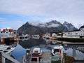 Henningsvær.
 Vågakallen towers over Henningsvær, seen from Kabelvåg.
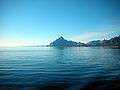 Vågakallen seen from east.
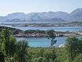 Gimsøystraumen between Gimsøy and Austvågø.
 Kabelvåg landscape with the Vågan Church; early June 2009.
References
- ↑ "Navn på steder og personer: Innbyggjarnamn" (in Norwegian). Språkrådet. Retrieved 2015-12-01.
- ↑ Store norske leksikon. "Vågan" (in Norwegian). Retrieved 2012-07-22.
- ↑ Jukvam, Dag (1999). "Historisk oversikt over endringer i kommune- og fylkesinndelingen" (PDF) (in Norwegian). Statistisk sentralbyrå.
- ↑ Rygh, Oluf (1905). Norske gaardnavne: Nordlands amt (in Norwegian) (16 ed.). Kristiania, Norge: W. C. Fabritius & sønners bogtrikkeri. p. 308.
- ↑ Norske Kommunevåpen (1990). "Nye kommunevåbener i Norden". Retrieved 2008-11-30.
- ↑ "eKlima Web Portal". Norwegian Meteorological Institute.
- ↑ "Table: 04813: Members of the local councils, by party/electoral list at the Municipal Council election (M)" (in Norwegian). Statistics Norway. 2015.
External links
| Wikimedia Commons has media related to Vågan. |
| Wikivoyage has a travel guide for Nordland. |
- Municipal fact sheet from Statistics Norway
- Lofoten Golf Links Golf court at Gimsøy in Vågan
- Laukvikøyene nature reserve, a wetland area with rich bird life (Norwegian)
- Polarlightcenter