April 2011 Iowa–Wisconsin tornado outbreak
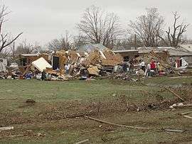 Damage from the Mapleton, Iowa tornado | |
| Type | Tornado outbreak |
|---|---|
| Duration | April 9 – April 11, 2011 |
| Tornadoes confirmed | 43 |
| Max rating1 | EF4 tornado |
| Duration of tornado outbreak2 | 48 hours, 6 minutes |
| Damage | $2.2 billion |
|
1Most severe tornado damage; see Enhanced Fujita scale 2Time from first tornado to last tornado | |
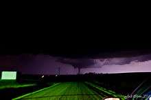
The April 2011 Iowa–Wisconsin tornado outbreak was one of several tornado outbreaks in the U.S. to take place during the record month of April 2011. Producing 43 tornadoes across five states, widespread damage took place; however, no fatalities resulted from the event due to timely warnings. In Wisconsin, 16 tornadoes touched down, ranking this outbreak as the state's largest April event on record as well as one of the largest single-day events during the course of any year. The strongest of these storms was an EF4 tornado that touched down south of Pocahontas, Iowa on April 9. Between 0256 and 0257 UTC (9:56 and 9:57 pm CDT) that day, five tornadoes were on the ground simultaneously in Pocahontas County, Iowa, all of which were from one supercell thunderstorm.
Throughout Iowa, damage from the storms is estimated at $78.6 million, much of which likely took place in and around Mapleton.[1] In addition to the tornadoes, Texas experienced a widespread straight-line wind and hail event, leaving $100 million in damage. Overall, losses from the storm system reached $2.2 billion, making it the third of a record ten billion dollar disasters in 2011.[2]
Meteorological synopsis
On April 9, a progressive upper-level trough moved east out of the Rocky Mountains and over the Midwest. Owing to early morning thunderstorms, moisture levels in the central Great Plains increased; however, capping in the region would limit daytime activity before atmospheric instability allowed for severe weather. forecast models indicated that the low-level jetstream would produce significant wind shear, aiding in the formation of possible tornadic supercell thunderstorms, and CAPE (convective available potential energy) values could exceed 3,000 j/kg. In light of this, the Storm Prediction Center (SPC) stated a moderate risk of severe weather for areas around the Minnesota-Iowa border. A slight risk was also defined for a broader region surrounding the moderate as well as a narrow line extending southward to Texas.[3] A warm front began developing along the southeastern side of the low pressure area as it moved over The Dakotas.[4]
During the evening hours of April 9, the SPC issued a tornado watch for western and northern Iowa, eastern Nebraska and southeast South Dakota. Conditions within this region were favorable for the development of multiple tornadic storms and there was a 70 percent chance of multiple touchdowns.[5] Around 2250 UTC (5:50 pm CDT), a strong thunderstorm developed over Burt/Cuming Counties in northeastern Nebraska. This cell slowly tracked east-northeastward and developed into a supercell as it moved into Monona County, Iowa. By 0021 UTC (7:21 pm CDT), a small tornado touched down roughly 2 miles (3.2 km) southwest of Mapleton. Within minutes, this storm quickly grew and intensified as it moved closer to the city. The tornado passed directly over the city at low-end EF3 strength. Turning northward, the tornado dissipated about 1 mile (1.6 km) north of Mapleton. A separate EF2 tornado struck the town of Early, where considerable damage occurred to homes and businesses.[6]
Tracking northeastward, the supercell moved into Ida County, another tornado touched down around 0115 UTC (8:15 pm CDT) to the west of Arthur.[7] This storm remained on the ground for 5 to 10 minutes, during which it damaged a few structures, before dissipating 2 miles (3.2 km) northwest of Arthur.[8] Around 0120 UTC (8:20 pm CDT), the cell entered Sac County and the first in a series of multiple tornadoes touched down northwest of Odebolt. Over the following three hours, 13 tornadoes touched down across several counties. Around 0208 UTC (9:08 pm CST), a 1.5 mi (2.4 km) wide, EF3 tornado touched down southwest of Pocahontas. Remaining on the ground for over an hour, this tornado meandered along a 30 mi (48 km) path, producing several satellite tornadoes.[9]
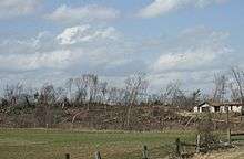
Officials blocked off the town and Governor Terry Branstad issued a disaster proclamation for the town. Early estimates indicated that 60% of the town was damaged and 20% was nearly flattened. Despite the damage, only three people sustained minor injuries.[10]
On April 10, another moderate risk was issued. A PDS Tornado Watch was issued for parts of Minnesota, Michigan, and Iowa, as well as most of Wisconsin. With 16 confirmed tornadoes in Wisconsin, the outbreak ranks as the largest single-day event in April in the state. Severe damage occurred in the towns of Merrill, Kaukauna, and Cottonville.[11] On the evening of April 10, a number of tornado watches and warning were issued stretching from southern Oklahoma to Sault. Ste. Marie, Michigan as well as central Ontario which became Canada's first tornado watch of the season. Thunderstorm watches and warnings were also reported as far away as northern and northwestern Ontario.[12]
List of tornadoes
| EF0 | EF1 | EF2 | EF3 | EF4 | EF5 | Total |
|---|---|---|---|---|---|---|
| 7 | 23 | 8 | 4 | 1 | 0 | 43 |
April 9 event
| List of reported tornadoes - Saturday, April 9, 2011 | ||||||
|---|---|---|---|---|---|---|
| | | | | | | |
| Iowa | ||||||
| EF3 | Mapleton area | Monona | 42°10′N 95°47′W / 42.17°N 95.79°W | 0021 | 3.5 miles (5.6 km) | Severe damage in town and a state of emergency was declared as a result of a large wedge tornado. Many houses and businesses were damaged or destroyed, with major damage to about 60% of the town and 20% nearly flattened. Severe tree and power line damage occurred as well. About 14 people were injured. |
| EF1 | NW of Ricketts | Crawford | Unknown | 0037 | 0.69 miles (1.11 km) | Brief tornado downed power lines. |
| EF2 | W of Arthur | Ida | 42°16′N 95°25′W / 42.27°N 95.41°W | 0115 | 4 miles (6.4 km) | Several buildings, including a farm house, were heavily damaged and trees and power lines were damaged. Two grain bins were destroyed as well. |
| EF3 | NW of Odebolt | Sac | 0123 | 10.14 miles (16.32 km) | Large wedge tornado destroyed or badly damaged numerous homes and farms. | |
| EF2 | N of Odebolt to Early | Sac | 0129 | 8.34 miles (13.42 km) | High-end EF2 tornado damaged or destroyed several homes and farm buildings. Buildings in downtown Early were badly damaged or destroyed, and several homes were damaged there as well.[13] | |
| EF0 | SW of Early | Sac | 0138 | 0.75 miles (1.21 km) | Satellite tornado to the previous storm; executed a small loop in a field shortly after touching down. Caused no damage. | |
| EF1 | S of Galva | Ida | 42°29′N 95°25′W / 42.48°N 95.42°W | 0140 | unknown | A farmstead was severely damaged with numerous outbuildings destroyed and a home losing its roof. A few other structures, including an ethanol plant, were also damaged. |
| EF3 | SW of Nemaha to SW of Havelock | Sac, Buena Vista, Pocahontas | 42°44′N 94°54′W / 42.74°N 94.90°W | 0208 | 30 miles (48 km) | Long-track, extremely large wedge tornado, with a damage swath 1.5 miles (2.4 km) wide, leveled several farmhouses and damaged others. Tornado struck the town of Varina, partially destroying a school building and severely damaging several homes. Numerous farm buildings were also damaged or destroyed. Farm equipment was destroyed and trees were snapped and uprooted. Tornado remained on the ground for more than an hour. From 0256 to 0257 UTC (9:56 to 9:57 pm CDT), this was one of five tornadoes on the ground simultaneously in Pocahontas County, all of which were satellite tornadoes to this.[13] |
| EF2 | NW of Nemaha | Sac, Buena Vista | 0209 | 12 miles (19 km) | Large wedge tornado, roughly 0.5 miles (0.80 km) wide, damaged or destroyed several homes and outbuildings. | |
| EF1 | S of Cherokee | Cherokee | 0220 | 5 miles (8.0 km) | Several barns and outbuildings sustained significant damage along the tornado's path and corn stubble was scoured. One home sustained roof and window damage and nearby truck trailers were flipped. A confinement building was also destroyed by the tornado. Numerous trees and power poles were snapped as well. | |
| EF2 | SW of Pocahontas (2nd tornado) | Sac, Buena Vista, | 0224 | 1.75 miles (2.82 km) | First satellite tornado to the EF3 Varina tornado. Farms were damaged in the area. | |
| EF4 | W of Pocahontas (1st tornado) | Pocahontas | 0254 | 3.2 miles (5.1 km) | Second satellite tornado to the EF3 Varina tornado. Strongest tornado of the outbreak with 170 miles per hour (270 km/h) winds. One home was completely leveled by the tornado and swept off its foundation. Trees nearby were snapped and debarked. A combine, estimated at 30,000 pounds (14,000 kg) was tossed roughly 100 yards (91 m) as well.[14] | |
| EF1 | WSW of Pocahontas (1st tornado) | Pocahontas | 0255 | 1.5 miles (2.4 km) | Third satellite tornado to the EF3 Varina tornado. On the ground at the same time as the following tornado. Relatively minor damage. | |
| EF1 | WSW of Pocahontas | Pocahontas | 0255 | 1.6 miles (2.6 km) | Fourth satellite tornado to the EF3 Varina tornado. Anticyclonic tornado paired with the previous cyclonic tornado. Relatively minor damage. | |
| EF2 | W of Pocahontas (2nd tornado) | Pocahontas | 0256 | 0.9 miles (1.4 km) | Fifth satellite tornado to the EF3 Varina tornado. One home was badly damaged. | |
| EF1 | W of Pocahontas (3rd tornado) | Pocahontas | 0308 | 2.4 miles (3.9 km) | At least one home was damaged. | |
| EF1 | NW of St. Joseph | Kossuth | 42°55′N 94°17′W / 42.92°N 94.28°W | 0419 | 0.8 miles (1.3 km) | A hog barn was damaged, numerous windows blown out and half of a shed collapsed. |
| EF0 | S of Sulpher Springs | Buena Vista | unknown | 1 mile (1.6 km) | Brief tornado with no damage. | |
| EF1 | SE of Newell | Buena Vista | unknown | 1 mile (1.6 km) | Tornado damaged outbuildings and farm structures. | |
| EF0 | SW of Alta (1st tornado) | Buena Vista | unknown | unknown | Brief tornado with no damage. Occurred simultaneously with the other Alta tornado. | |
| EF0 | SW of Alta (2nd tornado) | Buena Vista | unknown | unknown | Brief tornado with no damage. Occurred simultaneously with the other Alta tornado. | |
| Sources: | ||||||
April 10 event
| List of reported tornadoes - Sunday, April 10, 2011 | ||||||
|---|---|---|---|---|---|---|
| | | | | | | |
| Wisconsin | ||||||
| EF1 | SW of Augusta | Eau Claire | 44°38′N 91°11′W / 44.64°N 91.18°W | 2157 | 1.5 miles (2.4 km) | Brief tornado destroyed a garage and damaged two farmsteads and a barn. Earliest tornado to touch down in Eau Claire County during the course of a year on record. Previous earliest was May 10. |
| EF1 | NW of Augusta | Eau Claire | 44°42′N 91°09′W / 44.70°N 91.15°W | 2204 | 0.5 miles (800 m) | Two outbuildings destroyed and three more damaged. Significant tree damage as well. |
| EF3 | Merrill area | Lincoln, Marathon | 45°08′N 89°41′W / 45.14°N 89.68°W | 2308 | 22 miles (35 km) | Severe damage in the area, especially at and around the Merrill Airport where hangars and airplanes were destroyed. Throughout Merrill, 65 homes were damaged or destroyed and three people sustained injuries.[15] One man was thrown 200 ft (61 m) from his home as it was destroyed. Overall damage was estimated at $10.8 million, most of which took place at an industrial park, where multiple large metal buildings were severely damaged. Many trees were snapped and uprooted along the path.[16] |
| EF2 | Cottonville area | Adams | 44°02′N 89°54′W / 44.03°N 89.90°W | 2312 | 17 miles (27 km) | Homes sustained roof damage and mobile homes were destroyed. Extensive tree damage also occurred along with barns and sheds destroyed. A camping trailer was also overturned and sheet metal was wrapped around trees. A cement silo was blown over and multiple vehicles were flipped. A lake association building was destroyed and irrigation pivots were flipped and twisted.[15] Preliminary losses from the tornado reached $2.25 million.[17] |
| EF1 | SSW of Necedah | Juneau | 43°59′N 90°05′W / 43.98°N 90.09°W | 2314 | 4.5 miles (7.2 km) | A mobile home was rolled over and pine trees were snapped. |
| EF1 | SW of Hancock | Adams, Waushara | 44°04′N 89°40′W / 44.06°N 89.67°W | 2333 | 9.3 miles (15.0 km) | Trees and power poles downed. Homes sustained roof damage and irrigation systems were destroyed. |
| EF1 | SE of Parrish | Langlade | 45°24′N 89°24′W / 45.40°N 89.40°W | 2350 | 5.3 miles (8.5 km) | 1 million trees snapped or uprooted and a cabin was destroyed. |
| EF1 | S of Fremont | Waushara, Waupaca | 44°14′N 88°52′W / 44.23°N 88.86°W | 0015 | 8 miles (13 km) | Multiple barns were destroyed and highway signs were damaged. The roof was torn off one house in Readfield and the steeple was torn off the church. |
| EF2 | E of Argonne | Forest, Florence | 45°38′N 88°49′W / 45.64°N 88.82°W | 0031 | 13 miles (21 km) | Extensive tree and power line damage. A roof was torn off of a home and several barns and garages were destroyed as well. |
| EF1 | NE of Poy Sippi | Waushara, Winnebago | 44°10′N 89°00′W / 44.16°N 89.00°W | 0053 | 14.9 miles (24.0 km) | Intermittent tornado touchdown with barns and buildings damaged. Roof damage to homes occurred and extensive tree damage was noted. Crossed over Lake Poygan into Winnebago County where mobile homes were damaged and flipped. |
| EF1 | W of Armstrong Creek | Forest | 45°39′N 88°30′W / 45.65°N 88.50°W | 0108 | 4.5 miles (7.2 km) | Two homes damaged and a garage was destroyed. Many trees were snapped in the area. Barns were also destroyed. |
| EF2 | Kaukauna area | Outagamie | 44°16′N 88°16′W / 44.26°N 88.26°W | 0144 | 1.5 miles (2.4 km) | Over 170 houses were damaged in the community, some of them losing roofs. Large trees were uprooted or snapped. A church sustained roof damage and had air conditioning units torn off. |
| EF1 | S of Greenleaf | Brown | 44°16′N 88°05′W / 44.27°N 88.09°W | 0153 | 1.1 miles (1.8 km) | Silos were damaged and a barn roof was ripped off. |
| EF1 | S of Stockbridge | Calumet | 44°03′N 88°17′W / 44.05°N 88.29°W | 0159 | 1.1 miles (1.8 km) | Minor damage to 4 homes and the roof was torn off of a metal storage building. |
| EF0 | SSE of Berlin | Green Lake | Unknown | Unknown | 2 miles (3.2 km) | Brief tornado damaged a home and tossed furniture. A wooden building was damaged and tree limbs were snapped. |
| EF0 | N of Hamburg | Lincoln, Marathon | 45°04′N 89°32′W / 45.06°N 89.53°W | unknown | 1 mile (1.6 km) | Trees were uprooted and branches were snapped. A home had siding peeled off and several barns were damaged or destroyed. |
| Missouri | ||||||
| EF0 | N of Rogersville | Webster | 37°09′N 93°04′W / 37.15°N 93.06°W | 0355 | 6 mi (9.7 km) | Damage to trees and outbuildings. |
| Sources: NWS Twin Cities, NWS La Crosse, NWS Green Bay, NWS Springfield | ||||||
April 11 event
| List of reported tornadoes - Monday, April 11, 2011 | ||||||
|---|---|---|---|---|---|---|
| | | | | | | |
| Texas | ||||||
| EF1 | NNW of Rio Vista | Johnson | 32°16′N 97°26′W / 32.27°N 97.43°W | 0609 | 100 yards (91 m) | Five houses were damaged, one of them heavily and a wall was torn from a pharmacy. Mobile homes were also damaged and barns were destroyed. Trees were downed as well. |
| EF1 | W of Alvarado | Johnson | 32°24′N 97°13′W / 32.40°N 97.22°W | 0622 | 200 yards (180 m) | Mobile homes were flipped and 5 businesses were damaged. 2 people were injured. |
| EF1 | Forney area | Kaufman | 32°35′N 96°19′W / 32.58°N 96.32°W | 0713 | 0.5 miles (800 m) | Several houses sustained roof damage and a truck stop sign was blown over. |
| EF1 | S of Cash | Hunt | 32°59′N 96°08′W / 32.98°N 96.13°W | 0734 | 7 miles (11 km) | Two houses were heavily damaged and numerous other houses sustained lesser damage. Mobile homes in the area were badly damaged or destroyed. Sheds and trees were damaged. A pipe manufacturing plant was damaged and 4 trailers were blown across the highway was well. |
| Alabama | ||||||
| EF1 | Vestavia Hills | Jefferson | 33°27′N 86°47′W / 33.45°N 86.78°W | 0027 | 0.4 miles (640 m) | Brief tornado embedded in larger microburst. One house was heavily damaged and numerous trees were snapped. |
| Sources: | ||||||
Non-tornadic events
Accompanying the tornadoes, large hail and high winds also impacted parts of the Midwest. Initially, these events associated with the outbreak were confined to Iowa and parts of Nebraska and Minnesota on April 9. In Iowa, hail was measured up to 3.5 in (8.9 cm) in diameter, resulting in some damage to homes and cars.[7] On April 10, a large line of severe storms produced damage from northern Minnesota southward to the Texas-Mexico border. Most damage along this line resulted from straight-line winds; however, Wisconsin, 2 to 2.5 in (5.1 to 6.4 cm) diameter hail in La Crosse broke windows, dented cars and damaged homes.[18] Roughly 3,200 insurance claims worth $12 million were later made in the city.[19] Elsewhere in the state, winds up to 65 mph (105 km/h) downed numerous trees and power lines and in some instances tore roofs of buildings.[20]
In Texas, winds as high as 95 mph (153 km/h) caused extensive damage to homes and businesses, resulting in roughly $100 million in damage.[21][22] Numerous trees were felled across the region and a few structures were destroyed. In Dallas County, a few carports collapsed. Near Venus, 82 mph (132 km/h) winds damaged five homes.[20]
On April 11, a strong derecho brought widespread damage to much of northern Alabama as well as parts of Mississippi, Georgia and Tennessee. Near Brent, Alabama, a wind gust of 110 mph (180 km/h) was recorded 70 ft (21 m) up on a radio tower.[20]
Aftermath
Within days of the tornadoes in Iowa, excavators were brought in to clear debris and tear down homes that were damaged beyond repair.[23] On May 5, nearly a month after the outbreak, President Barack Obama signed a federal disaster declaration for Buena Vista, Cherokee, Ida, Monona, Pocahontas and Sac Counties in Iowa. This allowed for government aid to be sent to the region and aid in recovery efforts.[24] This declaration is set to remain in effect until May 1, 2012.[25] A disaster outreach center was opened on May 6 at the Mapleton City Hall and the American Legion Post in Varina and would remain open through May 26. At these places, residents would be allowed to apply for small business and homeowner loans up to $2 million and $200,000 respectively.[26]
References
- ↑ Nancy Gaarder (May 6, 2011). "Aid on way for April storms". Omaha World-Herald. Archived from the original on May 14, 2011. Retrieved May 14, 2011.
- ↑ "Billion Dollar U.S. Weather/Climate Disasters". National Climatic Data Center. 2011. Retrieved November 12, 2011.
- ↑ Mark Darrow and Melissa Hurlbut (April 9, 2011). "Apr 9, 2011 0600 UTC Day 1 Convective Outlook". Storm Prediction Center. National Oceanic and Atmospheric Administration. Retrieved April 14, 2011.
- ↑ Elizabeth Stoppkotte and John Hales (April 9, 2011). "Apr 9, 2011 1630 UTC Day 1 Convective Outlook". Storm Prediction Center. National Oceanic and Atmospheric Administration. Retrieved April 14, 2011.
- ↑ Sarah Corfidi (April 9, 2011). "Tornado Watch 116". Storm Prediction Center. National Oceanic and Atmospheric Administration. Archived from the original on 19 April 2011. Retrieved May 14, 2011.
- ↑ "Tornado Damage In Monona County, Iowa, Including Mapleton". National Weather Service Office in Omaha, Nebraska. National Oceanic and Atmospheric Administration. April 10, 2011. Retrieved May 14, 2011.
- 1 2 "April 9, 2011 Storm Reports". Storm Prediction Center. National Oceanic and Atmospheric Administration. April 19, 2011. Archived from the original on 19 April 2011. Retrieved May 14, 2011.
- ↑ "Damage survey for Arthur, Iowa and Cherokee County tornado". National Weather Service Office in Omaha, Nebraska. National Oceanic and Atmospheric Administration. April 21, 2011. Retrieved May 14, 2011.
- ↑ "Tornado Damage Survey April 9, 2011 -- Pocahontas Tornado Upgraded to EF4". National Weather Service Office in Des Moines, Iowa. National Oceanic and Atmospheric Administration. May 3, 2011. Retrieved May 14, 2011.
- ↑ Unattributed (April 10, 2011). "Mayor: Over half of Iowa town damaged by tornado". Associated Press. Archived from the original on April 10, 2011. Retrieved April 10, 2011.
- ↑ John Rondy (April 11, 2011). "Possible seven Wisconsin tornadoes may be record". Reuters. Archived from the original on April 12, 2011. Retrieved April 12, 2011.
- ↑ Storms cause havoc in Ontario Archived April 25, 2013, at the Wayback Machine. - The Weather Network, April 11, 2011
- 1 2 http://www.nemahaweb.com/nemahaia/2011tornado.htm
- ↑ Melanie S. Welte (May 3, 2011). "Strength of tornado in Pocahontas County raised". Chicago Tribune. Archived from the original on May 4, 2011. Retrieved May 4, 2011.
- 1 2 Jeff Starck (April 11, 2011). "Merrill tornado damages 65 homes, causes millions in damages". Green Bay Press-Gazette. Archived from the original on April 12, 2011. Retrieved April 12, 2011.
- ↑ Unattributed (April 12, 2011). "Merrill tornado causes $11M damage, hurls man 200 feet". Green Bay Post-Gazette. Archived from the original on April 13, 2011. Retrieved April 12, 2011.
- ↑ Adam Wise (April 11, 2011). "Tornado causes more than $2 million in damage". Green Bay Post-Gazette. Archived from the original on April 12, 2011. Retrieved April 12, 2011.
- ↑ "April 10, 2011 Storm Reports". Storm Prediction Center. National Oceanic and Atmospheric Administration. April 20, 2011. Archived from the original on 14 June 2011. Retrieved May 31, 2011.
- ↑ Paul Gores (May 29, 2011). "Spring storms take toll on insurers". Milwaukee-Wisconsin Journal Sentinel. Retrieved May 31, 2011.
- 1 2 3 "Hail, Thunderstorm Wind Damage & Thunderstorm Wind Gust events for the U.S.". National Weather Service Office in San Diego, California. National Oceanic and Atmospheric Administration. April 2011. Retrieved May 31, 2011.
- ↑ "April 10-11, 2011 North Texas Severe Storms". National Weather Service Office in Fort Worth, Texas. National Oceanic and Atmospheric Administration. April 13, 2011. Retrieved May 31, 2011.
- ↑ Shane Allen (April 13, 2011). "Strong Storms, Tornadoes Cause Estimated $100M in Damages". NBC Dallas-Fort Worth. Retrieved April 14, 2011.
- ↑ Dolly A. Butz (April 18, 2011). "Feds, state officials tour Mapleton". Quad City Times. Archived from the original on May 14, 2011. Retrieved May 14, 2011.
- ↑ "President Declares Major Disaster for Iowa". Federal Emergency Management Agency. May 5, 2011. Retrieved May 14, 2011.
- ↑ "Declaration Detail: M1977". Federal Emergency Management Agency. May 5, 2011. Retrieved May 14, 2011.
- ↑ Unattributed (May 6, 2011). "SBA offers loans for tornado recovery". The Des Moines Register. Archived from the original on May 14, 2011. Retrieved May 14, 2011.