Arnold Creek, Portland, Oregon
| Arnold Creek | |
|---|---|
| Neighborhood | |
 Arnold Creek | |
|
Coordinates: 45°26′29″N 122°41′59″W / 45.44134°N 122.69983°WCoordinates: 45°26′29″N 122°41′59″W / 45.44134°N 122.69983°W PDF map | |
| Country | United States |
| State | Oregon |
| City | Portland |
| Government | |
| • Association | Arnold Creek Neighborhood Association |
| • Coalition | Southwest Neighborhoods, Inc. |
| Area | |
| • Total | 1.07 sq mi (2.76 km2) |
| Population (2000)[1] | |
| • Total | 2,930 |
| • Density | 2,750/sq mi (1,062/km2) |
| Housing[1] | |
| • No. of households | 1037 |
| • Occupancy rate | 97% occupied |
| • % households renting | 6% renting |
| • Avg. household size | 2.83 persons |
.jpg)
SW Arnold Street at 35th Avenue near Arnold Creek
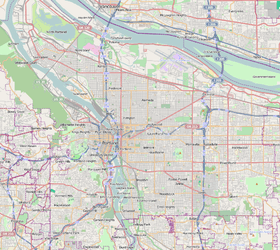
Arnold Creek is a neighborhood (and a creek) in the Southwest section of Portland, Oregon, just north of the city of Lake Oswego and Clackamas County. It borders West Portland Park to the west, Markham and Marshall Park to the north, Collins View and Tryon Creek State Natural Area to the east, and Lake Oswego and the unincorporated Multnomah County enclave of Englewood to the south.
Part of Maricara Natural Area (1988) is located in Arnold Creek (as well as in Markham).
References
External links
This article is issued from Wikipedia - version of the 9/8/2016. The text is available under the Creative Commons Attribution/Share Alike but additional terms may apply for the media files.