BB postcode area

Postcode district boundaries: Bing / Google

KML is from Wikidata
Blackburn postcode area
BB
Postcode area BB
Postcode area name Blackburn
Post towns 9
Postcode districts 15
Postcode sectors 79
Postcodes (live) 13,074
Postcodes (total) 18,150
Statistics as at February 2012[1]

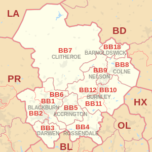
The BB postcode area, also known as the Blackburn postcode area,[2] is a group of postcode districts around Accrington, Barnoldswick, Blackburn, Burnley, Clitheroe, Colne, Darwen, Nelson and Rossendale in England.

Coverage

The approximate coverage of the postcode districts:

Postcode district Post town Coverage Local authority area
BB0 BLACKBURN Non-geographic postcode - Granby Marketing, Blackburn[3] Blackburn
BB1 BLACKBURN Blackburn, Bank Hey, Belthorn, Blackamoor, Clayton-le-Dale, Guide, Knuzden, Mellor, Ramsgreave, Rishton, Salesbury, Shadsworth, Sunnybower, Whitebirk, Wilpshire Blackburn with Darwen/Hyndburn/Ribble Valley
BB2 BLACKBURN Blackburn, Beardwood, Balderstone, Cherry Tree, Feniscowles, Griffin, Holly Tree, Livesey, Mellor, Mellor Brook, Mill Hill, Osbaldeston, Pleasington, Witton Blackburn with Darwen/Chorley/South Ribble/Ribble Valley
BB3 DARWEN Darwen, Bank Fold, Eccleshill, Hoddlesden, Livesey, Lower Darwen, Pickup Bank, Tockholes Blackburn with Darwen
BB4 ROSSENDALE Acre, Balladen, Bent Gate, Cloughfold, Cowpe, Crawshawbooth, Haslingden, Helmshore, Lumb (near Rawtenstall), Newchurch, Rawtenstall, Waterfoot, Weir Rossendale
BB5 ACCRINGTON Accrington, Altham, Baxenden, Church, Clayton-le-Moors, Huncoat, Oswaldtwistle, Rising Bridge Hyndburn/Rossendale
BB6 BLACKBURN Dinckley, Great Harwood, Langho Hyndburn/Ribble Valley
BB7 CLITHEROE Clitheroe, Barrow, Bashall Eaves, Billington, Bolton-by-Bowland, Chatburn, Downham, Dunsop Bridge, Gisburn, Great Mitton, Grindleton, Hurst Green, Little Mitton, Middop, Newsholme, Newton-in-Bowland, Paythorne, Pendleton, Rimington, Sabden, Sawley, Slaidburn, Twiston, Waddington, Whalley, Whitewell, Wiswell, Worston Ribble Valley
BB8 COLNE Colne, Foulridge, Laneshaw Bridge, Trawden, Winewall, Wycoller Pendle
BB9 NELSON Nelson, Barrowford, Blacko, Brierfield, Higherford, Roughlee Pendle
BB10 BURNLEY Burnley, Cliviger, Haggate, Harle Syke, Reedley, Worsthorne Burnley/Pendle
BB11 BURNLEY Burnley, Dunnockshaw and Clowbridge, Hapton Burnley
BB12 BURNLEY Burnley, Barley, Fence, Hapton, Higham, Padiham, Read, Simonstone, Wheatley Lane Burnley/Pendle/Ribble Valley
BB18 BARNOLDSWICK Barnoldswick, Bracewell and Brogden, Earby, Kelbrook, Salterforth, Sough Pendle
BB94 BARNOLDSWICK Non-geographic postcode - Holiday Cottages Group, Earby[3] non-geographic

Map

KML is from Wikidata
BB postcode area map, showing postcode districts, post towns and neighbouring postcode areas. BD postcode area BL postcode area HX postcode area LA postcode area OL postcode area PR postcode area
BB postcode area map, showing postcode districts in red and post towns in grey text, with links to nearby BD, BL, HX, LA, OL and PR postcode areas.

See also

References

  1. "ONS Postcode Directory Version Notes" (ZIP). National Statistics Postcode Products. Office for National Statistics. February 2012. Table 2. Retrieved 21 April 2012. Coordinates from mean of unit postcode points, "Code-Point Open". OS OpenData. Ordnance Survey. February 2012. Retrieved 21 April 2012.
  2. Royal Mail, Address Management Guide, (2004)
  3. 1 2 "Royal Mail non-geographic postcodes" (PDF). Royal Mail. 2007-03-07. Retrieved 2008-03-10.

External links

This article is issued from Wikipedia - version of the 10/27/2016. The text is available under the Creative Commons Attribution/Share Alike but additional terms may apply for the media files.