HD postcode area
Postcode district boundaries: Bing / Google
| Huddersfield postcode area | |
|---|---|
 HD | |
| Postcode area | HD |
| Postcode area name | Huddersfield |
| Post towns | 3 |
| Postcode districts | 9 |
| Postcode sectors | 42 |
| Postcodes (live) | 7,124 |
| Postcodes (total) | 10,457 |
| Statistics as at February 2012[1] | |
The HD postcode area, also known as the Huddersfield postcode area,[2] is a group of postcode districts around Brighouse, Holmfirth and Huddersfield in England.
Coverage
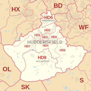
The approximate coverage of the postcode districts:
| Postcode district | Post town | Coverage | Local authority area |
|---|---|---|---|
| HD1 | HUDDERSFIELD | Huddersfield Town Centre, Hillhouse, Lockwood, Marsh, Paddock. | Kirklees |
| HD2 | HUDDERSFIELD | Birkby, Brackenhall, Bradley, Deighton, Fartown, Fixby, Sheepridge. | Kirklees |
| HD3 | HUDDERSFIELD | Lindley, Longwood, Marsh, Milnsbridge, Oakes, Outlane, Quarmby, Paddock, Salendine Nook, Scammonden, . | Kirklees |
| HD4 | HUDDERSFIELD | Berry Brow, Cowlersley, Crosland Moor, Farnley Tyas, Netherton, Newsome, Lowerhouses, Stocksmoor. | Kirklees |
| HD5 | HUDDERSFIELD | Almondbury, Dalton, Kirkheaton, Moldgreen, Rawthorpe, Waterloo. | Kirklees |
| HD6 | BRIGHOUSE | Bailiff Bridge, Brighouse, Clifton, Rastrick, . | Calderdale |
| HD7 | HUDDERSFIELD | Golcar, Linthwaite, Marsden, Scapegoat Hill, Slaithwaite. | Kirklees |
| HD8 | HUDDERSFIELD | Clayton West, Denby Dale, Emley, Fenay Bridge, Kirkburton, Lepton, Scissett, Shelley, Shepley, Skelmanthorpe | Kirklees |
| HD9 | HOLMFIRTH | Birdsedge, Brockholes, Hepworth, Holme, Holmfirth, Honley, Meltham, Scholes, Upperthong, Wooldale. | Kirklees |
Map
See also
References
- ↑ "ONS Postcode Directory Version Notes" (ZIP). National Statistics Postcode Products. Office for National Statistics. February 2012. Table 2. Retrieved 21 April 2012. Coordinates from mean of unit postcode points, "Code-Point Open". OS OpenData. Ordnance Survey. February 2012. Retrieved 21 April 2012.
- ↑ Royal Mail, Address Management Guide, (2004)
External links
This article is issued from Wikipedia - version of the 8/3/2016. The text is available under the Creative Commons Attribution/Share Alike but additional terms may apply for the media files.