DY postcode area
Postcode district boundaries: Bing / Google
| Dudley postcode area | |
|---|---|
 DY | |
| Postcode area | DY |
| Postcode area name | Dudley |
| Post towns | 8 |
| Postcode districts | 14 |
| Postcode sectors | 59 |
| Postcodes (live) | 11,007 |
| Postcodes (total) | 13,997 |
| Statistics as at February 2012[1] | |
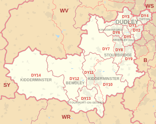
The DY postcode area, also known as the Dudley postcode area,[2] is a group of postcode districts around Bewdley, Brierley Hill, Dudley, Kidderminster, Kingswinford, Stourbridge, Stourport-on-Severn and Tipton in England. The mail is sorted at the North West Midlands Mail centre in Wolverhampton.
Coverage
The approximate coverage of the postcode districts:
| Postcode district | Post town | Coverage | Local authority area |
|---|---|---|---|
| DY1 | DUDLEY | Dudley town centre, Woodsetton (part of) | Dudley |
| DY2 | DUDLEY | Dudley town centre, Netherton, Woodside | Dudley |
| DY3 | DUDLEY | Gornal, Himley, Sedgley, Swindon, Gospel End, Woodsetton (part of) | Dudley, South Staffordshire |
| DY4 | TIPTON | Tipton, Coseley (part of), Tividale (part of) | Dudley, Sandwell |
| DY5 | BRIERLEY HILL | Brierley Hill, Pensnett, Quarry Bank | Dudley |
| DY6 | KINGSWINFORD | Kingswinford, Ashwood, Wall Heath | Dudley, South Staffordshire |
| DY7 | STOURBRIDGE | Enville, Kinver, Stourton | South Staffordshire |
| DY8 | STOURBRIDGE | Stourbridge town centre, Amblecote, Hagley (part of), Wollaston, Wordsley | Bromsgrove, Dudley, South Staffordshire |
| DY9 | STOURBRIDGE | Hagley (part of), Lye, Pedmore | Bromsgrove, Dudley |
| DY10 | KIDDERMINSTER | Kidderminster (east), Chaddesley Corbett, Blakedown, Cookley | Wyre Forest |
| DY11 | KIDDERMINSTER | Kidderminster (west), Hartlebury | Wychavon, Wyre Forest |
| DY12 | BEWDLEY | Bewdley, Arley, Hartlebury, Wolverley | Wyre Forest |
| DY13 | STOURPORT-ON-SEVERN | Stourport-on-Severn | Wyre Forest |
| DY14 | KIDDERMINSTER | Cleobury Mortimer | Shropshire |
Map
See also
References
- ↑ "ONS Postcode Directory Version Notes" (ZIP). National Statistics Postcode Products. Office for National Statistics. February 2012. Table 2. Retrieved 21 April 2012. Coordinates from mean of unit postcode points, "Code-Point Open". OS OpenData. Ordnance Survey. February 2012. Retrieved 21 April 2012.
- ↑ Royal Mail, Address Management Guide, (2004)
External links
This article is issued from Wikipedia - version of the 12/1/2016. The text is available under the Creative Commons Attribution/Share Alike but additional terms may apply for the media files.