Balagny-sur-Thérain
| Balagny-sur-Thérain | ||
|---|---|---|
|
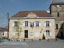
Town hall | ||
| ||
 Balagny-sur-Thérain | ||
|
Location within Hauts-de-France region  Balagny-sur-Thérain | ||
| Coordinates: 49°17′46″N 2°20′14″E / 49.2961°N 2.3372°ECoordinates: 49°17′46″N 2°20′14″E / 49.2961°N 2.3372°E | ||
| Country | France | |
| Region | Hauts-de-France | |
| Department | Oise | |
| Arrondissement | Senlis | |
| Canton | Neuilly-en-Thelle | |
| Intercommunality | Pays de Thelle | |
| Government | ||
| • Mayor (2008–2014) | Cécile Bremard | |
| Area1 | 6.8 km2 (2.6 sq mi) | |
| Population (2009)2 | 1,398 | |
| • Density | 210/km2 (530/sq mi) | |
| Time zone | CET (UTC+1) | |
| • Summer (DST) | CEST (UTC+2) | |
| INSEE/Postal code | 60044 / 60250 | |
| Elevation |
33–116 m (108–381 ft) (avg. 39 m or 128 ft) | |
|
1 French Land Register data, which excludes lakes, ponds, glaciers > 1 km² (0.386 sq mi or 247 acres) and river estuaries. 2 Population without double counting: residents of multiple communes (e.g., students and military personnel) only counted once. | ||
Balagny-sur-Thérain is a commune in the Oise department in northern France.
Population
| Historical population | ||
|---|---|---|
| Year | Pop. | ±% |
| 1793 | 506 | — |
| 1800 | 541 | +6.9% |
| 1806 | 560 | +3.5% |
| 1821 | 538 | −3.9% |
| 1831 | 620 | +15.2% |
| 1836 | 659 | +6.3% |
| 1841 | 761 | +15.5% |
| 1846 | 755 | −0.8% |
| 1851 | 707 | −6.4% |
| 1856 | 733 | +3.7% |
| 1861 | 730 | −0.4% |
| 1866 | 916 | +25.5% |
| 1872 | 960 | +4.8% |
| 1876 | 1,031 | +7.4% |
| 1881 | 1,173 | +13.8% |
| 1886 | 1,195 | +1.9% |
| 1891 | 1,253 | +4.9% |
| 1896 | 1,203 | −4.0% |
| 1901 | 1,163 | −3.3% |
| 1906 | 1,157 | −0.5% |
| 1911 | 1,141 | −1.4% |
| 1921 | 1,097 | −3.9% |
| 1926 | 1,121 | +2.2% |
| 1931 | 1,139 | +1.6% |
| 1936 | 1,169 | +2.6% |
| 1946 | 975 | −16.6% |
| 1954 | 1,147 | +17.6% |
| 1962 | 1,286 | +12.1% |
| 1968 | 1,332 | +3.6% |
| 1975 | 1,393 | +4.6% |
| 1982 | 1,299 | −6.7% |
| 1990 | 1,487 | +14.5% |
| 1999 | 1,419 | −4.6% |
| 2006 | 1,414 | −0.4% |
| 2009 | 1,398 | −1.1% |
See also
References
| Wikimedia Commons has media related to Balagny-sur-Thérain. |
This article is issued from Wikipedia - version of the 2/11/2016. The text is available under the Creative Commons Attribution/Share Alike but additional terms may apply for the media files.