Bangor, Morbihan
| Bangor | |
|---|---|
|
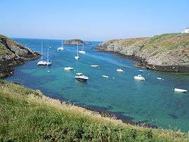
Port Goulphar | |
 Bangor | |
|
Location within Brittany region  Bangor | |
| Coordinates: 47°18′57″N 3°11′14″W / 47.3158°N 3.1872°WCoordinates: 47°18′57″N 3°11′14″W / 47.3158°N 3.1872°W | |
| Country | France |
| Region | Brittany |
| Department | Morbihan |
| Arrondissement | Lorient |
| Canton | Belle-Île |
| Intercommunality | Belle-Île-en-Mer |
| Government | |
| • Mayor (2014-2020) | Annaïck Huchet |
| Area1 | 25.54 km2 (9.86 sq mi) |
| Population (2010[1])2 | 932 |
| • Density | 36/km2 (95/sq mi) |
| Demonym(s) | Bangorins |
| Time zone | CET (UTC+1) |
| • Summer (DST) | CEST (UTC+2) |
| INSEE/Postal code | 56009 / 56360 |
| Elevation |
0–58 m (0–190 ft) (avg. 44 m or 144 ft) |
|
1 French Land Register data, which excludes lakes, ponds, glaciers > 1 km² (0.386 sq mi or 247 acres) and river estuaries. 2 Population without double counting: residents of multiple communes (e.g., students and military personnel) only counted once. | |
Bangor is a French commune in the Morbihan department in the Brittany region of north-western France. It is one of the four communes on the island of Belle-Île.
The inhabitants of Bangor are called Bangorins.[2]
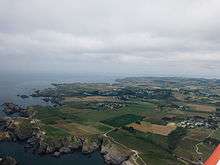
Geography
Bangor is one of four communes on the island of Belle Île located on the south-west coast of the island. The island is some 14 km south of the Quiberon peninsula. Access to the commune is by the D190 road from Le Palais in the north and the D25 from Locmaria in the east which continues to Sauzon in the north-west. There is the small Aerodrome de Belle-Île in the north of the commune which hosts the Aeroclub de Belle-Ile en Mer. Apart from the village there are many hamlets in the commune:
- Bordenec'h
- Bornor
- Borsauz
- Calestren
- Cosquet
- Domois
- Donnant
- Goélan
- Le Grand Village
- Kerguélen
- Kerourdé
- Kervarijon
- Parlavan
- Radenac
- Tinéüé
- Le Vazen
Several offshore islands also belong to the commune as well as other unnamed islets:
- Ile de Bangor
- Roches de Bornor
- Iles de Domois
- Iles de Baguenères
- Aiguilles Rocheuses
The commune consists almost entirely of farmland.[3]
Climate
The commune is exposed to strong winds.
| Town | Sunshine (hours/yr) |
Rain (mm/yr) | Snow (days/yr) | Storm (days/yr) | Fog (days/yr) |
|---|---|---|---|---|---|
| National Average | 1,973 | 770 | 14 | 22 | 40 |
| Bangor[5] | - | 712 | 1 | 6 | 26 |
| Paris | 1,661 | 637 | 12 | 18 | 10 |
| Nice | 2,724 | 767 | 1 | 29 | 1 |
| Strasbourg | 1,693 | 665 | 29 | 29 | 56 |
| Brest | 1,605 | 1,211 | 7 | 12 | 75 |
| Climate data for Belle-Ile | |||||||||||||
|---|---|---|---|---|---|---|---|---|---|---|---|---|---|
| Month | Jan | Feb | Mar | Apr | May | Jun | Jul | Aug | Sep | Oct | Nov | Dec | Year |
| Average high °C (°F) | 9.7 (49.5) |
9.5 (49.1) |
11.4 (52.5) |
13.5 (56.3) |
16.5 (61.7) |
19.2 (66.6) |
21.1 (70) |
21.4 (70.5) |
19.7 (67.5) |
16.4 (61.5) |
12.9 (55.2) |
10.5 (50.9) |
15.2 (59.4) |
| Daily mean °C (°F) | 7.9 (46.2) |
7.5 (45.5) |
9.2 (48.6) |
10.8 (51.4) |
13.7 (56.7) |
16.2 (61.2) |
18.2 (64.8) |
18.4 (65.1) |
16.8 (62.2) |
14.2 (57.6) |
10.9 (51.6) |
8.6 (47.5) |
12.7 (54.9) |
| Average low °C (°F) | 6.0 (42.8) |
5.4 (41.7) |
6.9 (44.4) |
8.0 (46.4) |
10.9 (51.6) |
13.2 (55.8) |
15.2 (59.4) |
15.3 (59.5) |
13.9 (57) |
12.0 (53.6) |
8.9 (48) |
6.6 (43.9) |
10.2 (50.4) |
| Average precipitation mm (inches) | 80.7 (3.177) |
63.3 (2.492) |
56.6 (2.228) |
45.4 (1.787) |
60.8 (2.394) |
32.5 (1.28) |
38.5 (1.516) |
36.2 (1.425) |
60.8 (2.394) |
86.9 (3.421) |
66.9 (2.634) |
82.9 (3.264) |
711.5 (28.012) |
| Average precipitation days (≥ 1 mm) | 13.3 | 9.4 | 10.4 | 8.6 | 9.1 | 6.6 | 6.5 | 6.0 | 7.9 | 12.0 | 12.2 | 13.6 | 115.6 |
| Source: Meteorological data for Belle-Ile - 37m altitude, from 1981 to 2010 January 2015 (French) | |||||||||||||
Neighbouring communes and villages[3]
 |
Sauzon | Le Palais | | |
| Atlantic Ocean | |
Locmaria | ||
| ||||
| | ||||
| Atlantic Ocean | Atlantic Ocean | Atlantic Ocean |
Toponymy
It is not known if the name comes from Bangor Abbey in Northern Ireland, one of the most famous abbeys in Western Christianity, from where it is known that monks like Columbanus came to evangelize in Armorica in the 6th century, or from the Monastery of Bangor-Fawr, founded in Wales around 545 on the Menai Strait.
The Breton name of the commune is Bangor.
History
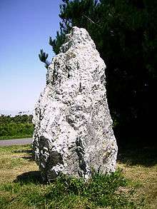
The commune of Bangor has been inhabited since prehistory as evidenced by the Pierre Sainte Anne menhir.
Bangor has been the administrative centre of the island for 10 centuries. It was the name of a priory founded by Benedictine monks who came to colonize and populate the island starting in the 7th century.
Colonization consisted of dividing the island into five parishes with Bangor occupying the middle Each parish was a small area given to residual families from the island or to colonists who were asked by the monks to come to Brittany.
In the 9th century the island was devastated by the Vikings and the priory was placed under the secular protection of the Counts of Cornouaille (in Armorican Brittany). In 1029 the Count of Cornouaille Alain Canhiart entrusted the island to the recently founded Sainte-Croix de Quimperlé Abbey. As it was directly under the authority of the Pope, Belle-Ile benefited from immunity from being under the authority of both the bishopric of Vannes and the duchy of Brittany. The administration of the island was delegated to a provost of the abbey who had temporal power (the right of low, middle, and high justice which was performed sometimes at Belle-Ile and sometimes at Quimperlé). From 1408 the right was exercised only at Quimperlé.
The Count of Cornouaille entrusted the island to the Benedictines of Redon Abbey who were able to take possession of it after long protests from the abbot of Quimperlé. The priory remained in the same spot as its predecessors (on the current location of the municipal campground of Bangor) and a fort was constructed at Le Palais which later became the capital of the island instead of Bangor.
Belle-Île was governed by monks until the 16th century when incessant attacks by pirates forced them to relinquish their fiefdom to the king, or rather to the regent Catherine de' Medici, who gave the land in vassalage to the Gondi family - then owners of the Pays de Retz. The land, however, remained under the heavy hand of the regime until the French Revolution.
The Goulphar lighthouse on the west coast of Bangor has been active since 1836.
The semaphore of Talut was put into service in 1862.[6]
Administration
| From | To | Name |
|---|---|---|
| 1791 | 1797 | Pierre Paul Sechant |
| 1797 | 1799 | Le Matelot |
| 1799 | 1809 | Pierre Paul Sechant |
| 1809 | 1810 | Jean Martin Labado |
| 1810 | 1818 | Jean Jacques Hippolyte Le Dru |
| 1818 | 1839 | Pierre Vincent Le Matelot |
| 1839 | 1844 | Le Dru |
| 1844 | 1852 | G. Sechant |
| 1852 | 1874 | Jean Patern Briere |
| 1874 | 1876 | Louis Marie Laleous |
| 1876 | 1896 | Mathurin L'Hermite |
| 1896 | 1900 | Pierre Marie L'Hermite |
| 1900 | 1919 | François Marie Le Bihan |
| 1919 | 1925 | Onésime Bénoni L'Hermite |
| 1925 | 1935 | Herve |
- Mayors from 1935
| From | To | Name | Party | Position |
|---|---|---|---|---|
| 1935 | 1946 | François Le Marec | ||
| 1946 | 1960 | Jean Marie Le Bihan | ||
| 1960 | 1971 | Paul Bedex | ||
| 1971 | 1977 | Adolphe Olieric | ||
| 1977 | 1983 | Paul Meunier | ||
| 1983 | 1989 | Jean Yves Daniel | ||
| 1989 | 2001 | Lucien Maho | ||
| 2001 | 2014 | Pierre-Yves Desard | ||
| 2014 | 2020 | Annaïck Huchet |
(Not all data is known)
Demography
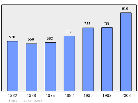
In 2010 the commune had 932 inhabitants. The evolution of the number of inhabitants is known from the population censuses conducted in the commune since 1793. From the 21st century, a census of communes with fewer than 10,000 inhabitants is held every five years, unlike larger communes that have a sample survey every year.[Note 1]
| 1793 | 1800 | 1806 | 1821 | 1831 | 1836 | 1841 | 1846 | 1851 |
|---|---|---|---|---|---|---|---|---|
| 1,218 | 1,183 | 1,005 | 1,418 | 1,638 | 1,762 | 1,742 | 1,712 | 1,820 |
| 1856 | 1861 | 1866 | 1872 | 1876 | 1881 | 1886 | 1891 | 1896 |
|---|---|---|---|---|---|---|---|---|
| 1,813 | 1,801 | 1,868 | 1,862 | 1,807 | 1,665 | 1,615 | 1,565 | 1,541 |
| 1901 | 1906 | 1911 | 1921 | 1926 | 1931 | 1936 | 1946 | 1954 |
|---|---|---|---|---|---|---|---|---|
| 1,454 | 1,484 | 1,342 | 1,074 | 1,017 | 988 | 929 | 809 | 670 |
| 1962 | 1968 | 1975 | 1982 | 1990 | 1999 | 2006 | 2010 | - |
|---|---|---|---|---|---|---|---|---|
| 578 | 550 | 563 | 637 | 735 | 738 | - | 932 | - |
Sources : Ldh/EHESS/Cassini until 1962, INSEE database from 1968 (population without double counting and municipal population from 2006)
Culture and heritage
Civil heritage
The commune has many buildings and structures that are registered as historical monuments:
- A Tumulus NE of the Aerodrome (Prehistoric)
 [8]
[8] - An old Radar Station at Port-Croton (20th century)[9]
- The Goulphar lighthouse (1826)[10] has one of the most powerful lights on the French coast. Built from 1826 to 1833, it was commissioned in 1835 and is a granite building 47 m high which rises to 84 m above the sea level. Its light beam flashes at intervals of 3 and 7 seconds. With the present optical system it is visible at 28 Nautical miles.
- Fortified works (18th century)[11]
- The Pierre Sainte Anne Menhir at Kervarijon (Prehistoric)[12]
- A Tumulus at Kervarijon (Prehistoric)[13]
- Houses (19th century)[14]
- The Town Hall (19th century)[15]
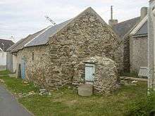
- A Bakery at Borsauz (18th century)[16]
- The Loge Agricultural Store room at Bordenec'h (19th century)[17]
- A Well at Radenac (19th century)[18]
- A Mill at Varrec (1858)[19]
Religious heritage
The commune has several religious buildings and structures that are registered as historical monuments:
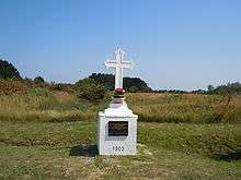
- Monumental Crosses (19th-20th century)[20]
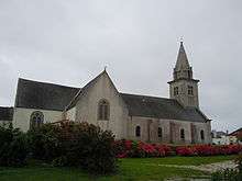
- The Parish Church of Saints Peter and Paul (16th century)[21]
- A Presbytery (1790)[22]
- The Chapels of Saint-Guénolé, Saint-Thomas, and Saint-Armand (destroyed)[23]
Bangor Picture Gallery
-
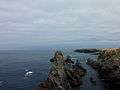
Aiguilles de Port-Coton.
-
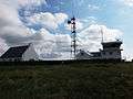
Semaphore of Talut.
-
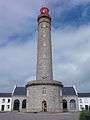
The Goulphar lighthouse.
-
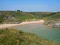
Herlin Beach
-
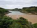
Port Kerel
-
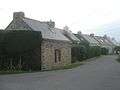
A line of Houses.
-
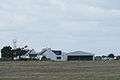
The Aero-club.[1]
- ^ Aero-club Belle-Ile Charles Robin (French)
Notable people linked to the commune
- John Peter Russell, Australian painter, arrived at Belle-Île-en-Mer in 1883. He first stayed in a rented house in Envag before building a mansion called the "Château de l'anglais" (English Chateau) at Goulphar.
- Claude Monet lived in the village of Kervilahouen
- Françoise Bangor, the first woman painter in Belle-Île, stayed in Envague. She often came on holidays with her parents and succumbed to the beauty of the island. She continued to paint the rugged coastline, the villages, and to sketch the fishermen from 1935 to 1953.[24]
- Henry Moret, painted Goulpher
- Paintings of Bangor
-
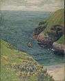
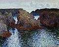
Henry Moret: Goulpher (actually Goulphar in 1895 or 1896,Musée d'Orsay)
-
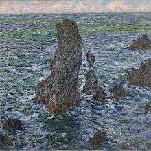
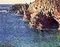
Claude Monet: Les Aiguilles de Port-Coton (Eagles of Port Coton), 1886
-
Claude Monet: Grotte de Port-Domois (Port Domois Cave), 1886
-
Claude Monet: Paysage à Port-Goulphar (Countryside at Port Goulphar), 1886
See also
External links
- Bangor official website (French)
- Bangor on the Gencom website (many links) (French)
- Bangor on the old National Geographic Institute website (French)
- Old postcards of Bangor (French)
- Page about Bangor, Belle-Ile, with a map of the small town (English)
- Bangor on Lion1906
- Bangor on Google Maps
- Bangor on Géoportail, National Geographic Institute (IGN) website (French)
- Bangor on the 1750 Cassini Map
- Bangor on the INSEE website (French)
- INSEE (French)
Notes and references
Notes
- ↑ At the beginning of the 21st century, the methods of identification have been modified by Law No. 2002-276 of 27 February 2002, the so-called "law of local democracy" and in particular Title V "census operations" allows, after a transitional period running from 2004 to 2008, the annual publication of the legal population of the different French administrative districts. For communes with a population greater than 10,000 inhabitants, a sample survey is conducted annually, the entire territory of these communes is taken into account at the end of the period of five years. The first "legal population" after 1999 under this new law came into force on 1 January 2009 and was based on the census of 2006.
References
- ↑ Insee - 2010 Legal population
- ↑ Inhabitants of Morbihan (French)
- 1 2 Google Maps
- ↑ Paris, Nice, Strasbourg, Brest
- ↑ Data from the Station at Belle-Ile from 1981 to 2010 (French)
- ↑ Office of Tourism of Belle-Île-en-Mer
- ↑ List of Mayors of France (French)
- ↑ Ministry of Culture, Mérimée IA00008946 Tumulus NE of the Aerodrome (French)
- ↑ Ministry of Culture, Mérimée PA56000026 Radar Station at Port-Croton (French)
- ↑ Ministry of Culture, Mérimée PA00135278 IA56000341 Goulphar lighthouse (French)

- ↑ Ministry of Culture, Mérimée IA00008975 Infantry Parapet at Port Guen IA00008974 Infantry Parapet at Port d'Herlin IA00008973 Pointe du Grand Village IA00008972 Entrechments at Port Kerel IA00008971 Port de Domois IA00008970 Pointe de Grand Guet (French)
- ↑ Ministry of Culture, Mérimée IA00008954 Pierre Sainte Anne Menhir at Kervarijon (French)
- ↑ Ministry of Culture, Mérimée IA00008945 Tumulus at Kervarijon (French)
- ↑ Ministry of Culture, Mérimée IA00008253 Radenac (1842) IA00008252 Domois (1859) IA00008242 Houses (French)
- ↑ Ministry of Culture, Mérimée IA00008251 Town Hall (French)
- ↑ Ministry of Culture, Mérimée IA00008247 Bakery at Borsauz (French)
- ↑ Ministry of Culture, Mérimée IA00008246 Loge Agricultural Store room at Bordenec'h (French)
- ↑ Ministry of Culture, Mérimée IA00008245 Well at Radenac (French)
- ↑ Ministry of Culture, Mérimée IA00008244 Mill at Varrec (French)
- ↑ Ministry of Culture, Mérimée IA00009007 Monumental Crosses (French)
- ↑ Ministry of Culture, Mérimée IA00008249 Parish Church of Saints Peter and Paul (French)
- ↑ Ministry of Culture, Mérimée IA00008248 Presbytery (French)
- ↑ Ministry of Culture, Mérimée IA00008241 Chapels of Saint-Guénolé, Saint-Thomas, and Saint-Armand (French)
- ↑ Françoise Oury, Bangor, 1905~1983 (French)
![]() Media related to Bangor, Morbihan at Wikimedia Commons
Media related to Bangor, Morbihan at Wikimedia Commons