Bassignac-le-Bas
| Bassignac-le-Bas | ||
|---|---|---|
| ||
 Bassignac-le-Bas | ||
|
Location within Nouvelle-Aquitaine region  Bassignac-le-Bas | ||
| Coordinates: 45°01′12″N 1°51′12″E / 45.02°N 1.8533°ECoordinates: 45°01′12″N 1°51′12″E / 45.02°N 1.8533°E | ||
| Country | France | |
| Region | Nouvelle-Aquitaine | |
| Department | Corrèze | |
| Arrondissement | Tulle | |
| Canton | Mercœur | |
| Intercommunality | Community of communes of Canton de Mercœur | |
| Government | ||
| • Mayor (2001–2020) | Jean-Pierre Lasserre | |
| Area1 | 12.29 km2 (4.75 sq mi) | |
| Population (2010)2 | 90 | |
| • Density | 7.3/km2 (19/sq mi) | |
| Time zone | CET (UTC+1) | |
| • Summer (DST) | CEST (UTC+2) | |
| INSEE/Postal code | 19017 / 19430 | |
| Elevation |
145–517 m (476–1,696 ft) (avg. 250 m or 820 ft) | |
|
1 French Land Register data, which excludes lakes, ponds, glaciers > 1 km² (0.386 sq mi or 247 acres) and river estuaries. 2 Population without double counting: residents of multiple communes (e.g., students and military personnel) only counted once. | ||
Bassignac-le-Bas is a French commune in the Corrèze department in the Nouvelle-Aquitaine region of central France.[1]
The inhabitants of the commune are known as Bassignacois or Bassignacoises.[2]
Geography
Bassignac-le-Bas is located some 30 km south-east of Brive-la-Gaillarde and 10 km south-west of Argentat. Access to the commune is by the D116 which comes from Argentat in the north-east and passes along the riverbank through the commune before continuing south to join the D940 at Beaulieu-sur-Dordogne. The D41 from Beaulieu-sur-Dordogne to La Chapelle-Saint-Géraud passes through the south-west of the commune. The D136 comes from Brivezac across the river and passes through the commune eastwards to join the D41 in the east of the commune. Apart from the village there are the hamlets of Vaurs, Recoudier, Le Peuch, Culagne, Chaviolle, La Gendrie, Le Gasquet, Brette, and La Laurie in the commune. The commune is mixed forest and farmland.[3][4]
The Dordogne river forms the western and northern borders of the commune as it flows south to eventually join the Garonne at Bayon-sur-Gironde. The Ruisseau de la Borie flows from a small lake in the east of the commune westwards to join the Dordogne. The Ruisseau de Layssot forms the north-eastern border of the commune as it flows north to join the Dordogne. The Ruisseau de Chauvac forms the southern border of the commune as it flows west to join the Dordogne.[3][4]
Mapping
A list of online mapping systems can be displayed by clicking on the coordinates (latitude and longitude) in the top right hand corner of this article.
Neighbouring communes and villages
 |
Chenailler-Mascheix | | ||
| Brivezac | |
Reygade | ||
| ||||
| | ||||
| Beaulieu-sur-Dordogne |
History
Bassignac-le-Bas appears as Baßignac le Bas on the 1750 Cassini Map[5] and as Bafignac leBas on the 1790 version.[6]
Heraldry
.svg.png) |
The official status of the blazon remains to be determined.
Blazon: |
Administration
| From | To | Name | Party | Position |
|---|---|---|---|---|
| 2001 | 2020[8] | Jean-Pierre Lasserre |
(Not all data is known)
Demography
In 2010 the commune had 90 inhabitants. The evolution of the number of inhabitants is known from the population censuses conducted in the commune since 1793. From the 21st century, a census of communes with fewer than 10,000 inhabitants is held every five years, unlike larger communes that have a sample survey every year.[Note 1]
| 1793 | 1800 | 1806 | 1821 | 1831 | 1836 | 1841 | 1846 | 1851 |
|---|---|---|---|---|---|---|---|---|
| 600 | 501 | 598 | 506 | 635 | 630 | 635 | 635 | 598 |
| 1856 | 1861 | 1866 | 1872 | 1876 | 1881 | 1886 | 1891 | 1896 |
|---|---|---|---|---|---|---|---|---|
| 633 | 632 | 586 | 600 | 599 | 652 | 598 | 588 | 566 |
| 1901 | 1906 | 1911 | 1921 | 1926 | 1931 | 1936 | 1946 | 1954 |
|---|---|---|---|---|---|---|---|---|
| 557 | 533 | 513 | 436 | 425 | 377 | 354 | 267 | 267 |
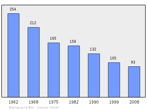
| 1962 | 1968 | 1975 | 1982 | 1990 | 1999 | 2006 | 2010 | - |
|---|---|---|---|---|---|---|---|---|
| 254 | 212 | 165 | 156 | 132 | 105 | 95 | 90 | - |
Sources : Ldh/EHESS/Cassini until 1962, INSEE database from 1968 (population without double counting and municipal population from 2006)
Culture and heritage
Religious heritage
The Parish Church of Saint Martin contains three items that are registered as historical objects:
- A Statue: Sainte Fauste (15th century)
 [9]
[9] - A Group Sculpture: Virgin of Pity (15th century)[10]
- A Bronze Bell (1611)[11]
See also
Notes and references
Notes
- ↑ At the beginning of the 21st century, the methods of identification have been modified by Law No. 2002-276 of 27 February 2002, the so-called "law of local democracy" and in particular Title V "census operations" allows, after a transitional period running from 2004 to 2008, the annual publication of the legal population of the different French administrative districts. For communes with a population greater than 10,000 inhabitants, a sample survey is conducted annually and the entire territory of these communes is taken into account at the end of the period of five years. The first "legal population" after 1999 under this new law came into force on 1 January 2009 and was based on the census of 2006.
References
- ↑ Bassignac-le-Bas on Lion1906
- ↑ Inhabitants of Corrèze (French)
- 1 2 3 Bassignac-le-Bas on Google Maps
- 1 2 Bassignac-le-Bas on the Géoportail from National Geographic Institute (IGN) website (French)
- ↑ Baßignac le Bas on the 1750 Cassini Map
- ↑ Bafignac leBas on the 1790 Cassini Map
- ↑ List of Mayors of France (French)
- ↑ General Council website Bassignac-le-Bas (French)
- ↑ Ministry of Culture, Palissy PM19000847 Statue: Sainte Fauste
 (French)
 - ↑ Ministry of Culture, Palissy PM19000845 Group Sculpture: Virgin of Pity
(French)
- ↑ Ministry of Culture, Palissy PM19000539 Bronze Bell
(French)
| Wikimedia Commons has media related to Bassignac-le-Bas. |