Chanac-les-Mines
| Chanac-les-Mines | ||
|---|---|---|
|
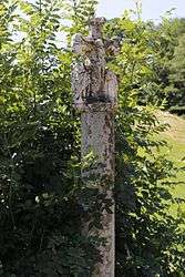
The Malangle Cross | ||
| ||
 Chanac-les-Mines | ||
|
Location within Nouvelle-Aquitaine region  Chanac-les-Mines | ||
| Coordinates: 45°15′55″N 1°49′14″E / 45.2653°N 1.8206°ECoordinates: 45°15′55″N 1°49′14″E / 45.2653°N 1.8206°E | ||
| Country | France | |
| Region | Nouvelle-Aquitaine | |
| Department | Corrèze | |
| Arrondissement | Tulle | |
| Canton | Tulle-Campagne-Sud | |
| Government | ||
| • Mayor (2008–2014) | Arnaud Collignon | |
| Area1 | 13.26 km2 (5.12 sq mi) | |
| Population (2008)2 | 503 | |
| • Density | 38/km2 (98/sq mi) | |
| Time zone | CET (UTC+1) | |
| • Summer (DST) | CEST (UTC+2) | |
| INSEE/Postal code | 19041 / 19150 | |
| Elevation |
218–466 m (715–1,529 ft) (avg. 325 m or 1,066 ft) | |
|
1 French Land Register data, which excludes lakes, ponds, glaciers > 1 km² (0.386 sq mi or 247 acres) and river estuaries. 2 Population without double counting: residents of multiple communes (e.g., students and military personnel) only counted once. | ||
.svg.png)
Chanac-les-Mines is a commune in the Corrèze department in central France.
Population
| Historical population | ||
|---|---|---|
| Year | Pop. | ±% |
| 1962 | 268 | — |
| 1968 | 291 | +8.6% |
| 1975 | 389 | +33.7% |
| 1982 | 511 | +31.4% |
| 1990 | 511 | +0.0% |
| 1999 | 482 | −5.7% |
| 2008 | 503 | +4.4% |
See also
References
| Wikimedia Commons has media related to Chanac-les-Mines. |
This article is issued from Wikipedia - version of the 2/18/2016. The text is available under the Creative Commons Attribution/Share Alike but additional terms may apply for the media files.