Pérols-sur-Vézère
| Pérols-sur-Vézère | ||
|---|---|---|
|
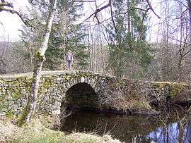
The Varieras bridge | ||
| ||
 Pérols-sur-Vézère | ||
|
Location within Nouvelle-Aquitaine region  Pérols-sur-Vézère | ||
| Coordinates: 45°35′13″N 1°58′50″E / 45.5869°N 1.9806°ECoordinates: 45°35′13″N 1°58′50″E / 45.5869°N 1.9806°E | ||
| Country | France | |
| Region | Nouvelle-Aquitaine | |
| Department | Corrèze | |
| Arrondissement | Ussel | |
| Canton | Bugeat | |
| Intercommunality | Bugeat - Sornac - Millevaches au Cœur | |
| Government | ||
| • Mayor (2008–2014) | Alain Fonfrede | |
| Area1 | 46.98 km2 (18.14 sq mi) | |
| Population (2008)2 | 185 | |
| • Density | 3.9/km2 (10/sq mi) | |
| Time zone | CET (UTC+1) | |
| • Summer (DST) | CEST (UTC+2) | |
| INSEE/Postal code | 19160 / 19170 | |
| Elevation | 708–943 m (2,323–3,094 ft) | |
|
1 French Land Register data, which excludes lakes, ponds, glaciers > 1 km² (0.386 sq mi or 247 acres) and river estuaries. 2 Population without double counting: residents of multiple communes (e.g., students and military personnel) only counted once. | ||
.svg.png)
Pérols-sur-Vézère (Occitan: Peròus) is a commune in the Corrèze department in central France.
Population
| Historical population | ||
|---|---|---|
| Year | Pop. | ±% |
| 1962 | 287 | — |
| 1968 | 373 | +30.0% |
| 1975 | 297 | −20.4% |
| 1982 | 229 | −22.9% |
| 1990 | 214 | −6.6% |
| 1999 | 182 | −15.0% |
| 2008 | 185 | +1.6% |
See also
References
| Wikimedia Commons has media related to Pérols-sur-Vézère. |
This article is issued from Wikipedia - version of the 3/15/2016. The text is available under the Creative Commons Attribution/Share Alike but additional terms may apply for the media files.