Bates-Hendricks
The Bates-Hendricks Neighborhood is situated just south and east of Indianapolis' downtown commercial district, and the redeveloped Fountain Square business district is just to the east.
Access to the neighborhood from the north is by way of East Street, while Terrace Street off of Madison Avenue enters the neighborhood from the west and Prospect Street offers access from Fountain Square.
Bates-Hendricks House
|
Bates Hendricks House | |
|
Bates Hendricks Hourse viewed from the southeast | |
   | |
| Location |
1626 S. New Jersey St. Indianapolis, Indiana, United States |
|---|---|
| Coordinates | 39°44′46.4″N 86°9′2.8″W / 39.746222°N 86.150778°W |
| Built | 1820s, 1851, 1858 |
| NRHP Reference # | 77000143 |
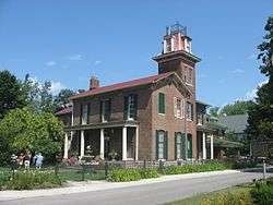
The neighborhood takes its name from the historic Bates-Hendricks House, located at 1526 S. New Jersey Street in the western part of the neighborhood. The house is listed on the National Register of Historic Places and home tours are offered by appointment.
The home was constructed in three phases. The first section was built in the early 1820s by Richard Keene, the lands patent holder. He had purchased the land from the federal government in July 1821 just as the Indians vacated the area. The second section was completed by Hervey Bates in 1851. The newest section was completed in 1858.
The smaller Keene section of the house is of Federal design. The larger Bates-built section is of Italianate design complete with a 60-foot (18 m) tower on the home's east exposure. The house is one of the oldest standing structures in Indianapolis and Marion County.[1]
Bates was Marion County's first sheriff (1822) and later, president of the Indianapolis branch of the state Bank of Indiana. He and Lanier (from Madison) brought the state's first railroad, the Madison and Indianapolis, to Indianapolis in 1847. In 1852 Bates built the lavish Bates House Hotel in downtown Indianapolis, where Abraham Lincoln stayed while en route to his first inauguration in Washington, D.C.
Thomas A. Hendricks also lived in the home; he served as U.S. Senator from Indiana, Governor of Indiana, and Vice-President of the United States.
James O. Woodruff built the Victorian neighborhood around the home in 1872, calling it Hendricks Place. He would later develop Woodruff Place on the east side of Indianapolis.
General John Coburn lived in the home for thirty years. He was first into Atlanta during the Civil War and secured the city's surrender. Upon his return to Indianapolis he became a four-time U.S. Congressman and set the cornerstone for the Soldiers and Sailors Monument.
In the early twentieth century the home's tower hosted one of the first radio transmitters in Indiana.
In 1971, a building survey was done for the Bates-Hendricks House. It was used as the basis of all historic building data information in the years to follow. A copy of the original survey was found in the Library of congress and reviewed against current known information. Many major errors were found in the 1971 document including the construction dates of the home. Currently, the Library of Congress Survey is being updated to reflect what is now known about the Bates-Hendricks structure.
Neighborhood history
Madison Avenue, the western boundary of the neighborhood, is the old Mauxferry Road. This was the first road built into Indian territory to service the new capital of Indianapolis. It was surveyed in 1822 and completed in 1824. It was the road used to move the tools of government from Corydon (the old state capitol) to Indianapolis. It also served as the stagecoach road to reach the steamboats on the Ohio River before the railroad era.
In October 1900, pharmacist John A. Hook opened the first Hook's Drug Store at the corner of Prospect and East Streets. Although that building no longer exists, Hook's grew to be a chain of over 160 stores throughout Indiana, and after several mergers, became part of the CVS Pharmacy chain.[2]
The Sanders-Childers House at 1020 E. Palmer Street is the oldest house in Indianapolis. It is a two-story brick farmhouse constructed around 1820 by William Sanders. The original portion of the house sits at an angle to Palmer and Barth streets because those streets were not laid out until later. Alterations were made at various times, including a modernization in the 1920s by Frank R. Childers, who was the Marion County Recorder from 1927 to 1930.[3] The former Abraham Lincoln School #18 across the street at 1001 E. Palmer Street was built in 1901 and is on the site where a group of Delaware Indians lived until 1820.[4]
Redevelopment
The neighborhood being near both Fountain Square and downtown Indianapolis is currently being redeveloped. Bates-Hendricks is currently transitioning from a home rental neighborhood back to a home owner neighborhood. It is currently offering home purchasers some of the best real estate values in the Indianapolis downtown area.
Most of the homes after complete renovation require less the a $100,000 investment. But banks require the new home owners to be properly qualified. The SEND development organization offers some redeveloped homes to lower income people.
In 2008-2009, the 1400 and 1500 blocks of S. New Jersey Street saw a major redevelopment of the housing along the street. New landscaping was also provided to the Woodruff-built esplanade that runs down the center of the street.
A similar project was undertaken in 2010 for the 1500 block of S. Alabama Street one block to the west, which contains the only other Woodruff-built esplanade in the neighborhood.
In 2010 the New Jersey Street project was awarded third-place in the 'Physical Revitalization Beautification – Single Neighborhood' division of the 'Neighborhood of the Year Awards' awarded by Neighborhoods USA (NUSA).[5]
Green space
Most of the Bates-Hendricks neighborhood consists of one- and two-family residences with small front yards and larger back yards. Besides the esplanades on New Jersey and Alabama streets, there are several public green spaces.
Hendricks Park, in the 1300 block of Madison Avenue, is part of the Indianapolis Department of Parks and Recreation. Construction began in late 2000 and finished in 2002. This small park, on the western edge of the neighborhood, is the site of Lars Jonker's abstract sculpture Play. The park also has a small pavilion.[6][7]
Ringgold Park at 1500 Ringgold Street is a .21-acre (0.085 ha) minipark with playground equipment.[8] The park was originally constructed in the early 1900s on .9 acres (0.36 ha) northwest of its current location. At that time it contained a bathing pool, but by 1936 the pool had been removed and swings and volleyball court had been added. By 1956 a baseball diamond had been laid out. In the 1960s, the construction of I-65 through the park resulted in the relocation to its current site.[9] A Keep Indianapolis Beautiful project to revitalize the park by installing native plantings and updating its equipment was begun in 2015.[10]
The Pleasant Run Trail cuts through the southeast corner of the neighborhood along the creek of the same name on its way to Garfield Park a half-mile south. The parkways on each side of the creek are part of the Indianapolis Park and Boulevard System designed by George Kessler.
Education
The James A. Garfield School 31, an Indianapolis Public Schools elementary school, is located at 307 Lincoln Street[11] across from the southern end of the Alabama Street esplanade.
Two public charter schools are also located within the Bates-Hendricks neighborhood. The Fountain Square Academy for grades 5-12 at 1615 S. Barth Avenue[12] and the Southeast Neighborhood School of Excellence (SENSE) for elementary grades at 1601 S. Barth Avenue[13] share a former industrial building.
References
- ↑ "Indiana State Historic Architectural and Archaeological Research Database (SHAARD)" (Searchable database). Department of Natural Resources, Division of Historic Preservation and Archaeology. Retrieved 2016-08-01. Note: This includes Lois Hagedorn (April 1975). "National Register of Historic Places Inventory Nomination Form: Bates-Hendricks House" (PDF). Retrieved 2016-08-01. and Accompanying photographs
- ↑ "Hook's Drugs, Inc. and Hook's American Drugstore Museum". Retrieved December 7, 2012.
- ↑ Taylor, ed, Robert M., Jr. Indiana: A New Historical Guide. Indiana Historical Society, 1989, p. 424
- ↑ Fountain Square The Polis Center, Retrieved October 10, 2010.
- ↑ Neighborhood of the Year Awards Neighborhoods USA,Retrieved 2010-10-10.
- ↑ "Public Space". Southeast Neighborhood Development. Retrieved May 24, 2016.
- ↑ "Hendricks Park". City of Indianapolis. Retrieved 2013-06-28.
- ↑ "Ringgold Park". Indianapolis Department of Parks and Recreation. February 16, 2011. Retrieved May 24, 2016.
- ↑ "Rediscovering Ringgold Park" (PDF). Bates Hendricks Neighborhood. Retrieved May 24, 2016.
- ↑ "Ringgold Park, 1513 Ringgold Ave; 46203". Keep Indianapolis Beautiful, Inc. Retrieved May 24, 2016.
- ↑ Indianapolis Public Schools Archived September 28, 2011, at the Wayback Machine. IPS Local Schools, Retrieved 2011-03-17.
- ↑ Fountain Square Academy Fountain Square Academy, Retrieved 2011-03-17.
- ↑ SENSE Charter School SENSE Charter School, Retrieved 2011-03-17.
External links
Coordinates: 39°44′49″N 86°08′49″W / 39.747°N 86.147°W