Crows Nest, Indiana
| Town of Crows Nest, Indiana | |
|---|---|
| Town | |
|
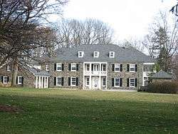
The former home of Eli Lilly is located in Crows Nest. | |
 Location in the state of Indiana | |
| Coordinates: 39°51′8″N 86°10′22″W / 39.85222°N 86.17278°WCoordinates: 39°51′8″N 86°10′22″W / 39.85222°N 86.17278°W | |
| Country | United States |
| State | Indiana |
| County | Marion |
| Township | Washington |
| Area[1] | |
| • Total | 0.43 sq mi (1.11 km2) |
| • Land | 0.43 sq mi (1.11 km2) |
| • Water | 0 sq mi (0 km2) |
| Elevation | 774 ft (236 m) |
| Population (2010)[2] | |
| • Total | 73 |
| • Estimate (2012[3]) | 74 |
| • Density | 169.8/sq mi (65.6/km2) |
| Time zone | EST (UTC-5) |
| • Summer (DST) | EST (UTC-5) |
| FIPS code | 18-16156[4] |
| GNIS feature ID | 0433220[5] |
| Website | |
|
Town of Crows Nest Historic District | |
  | |
| Location | Roughly bounded by Kessler Blvd., White R., and Questover Circle, Indianapolis |
| Area | 65 acres (26 ha) |
| Architectural style | Colonial Revival, Tudor Revival, et al. |
| NRHP Reference # | 00000305[6] |
| Added to NRHP | April 13, 2000 |
The Town of Crows Nest is located in Washington Township, Marion County, Indiana, approximately 7 miles (11 km) northwest of downtown Indianapolis. The town is adjacent to the neighboring community of North Crows Nest. It includes two streets: Sunset Lane south of Kessler Boulevard and Questover Circle. The population was 73 at the 2010 census.[7] It has existed as an "included town" since 1970, when it was incorporated into Indianapolis as part of Unigov. It is part of Indianapolis, but retains a functioning town government under IC 36-3-1-11.[8]
History
Crows Nest was founded in 1927, and supposedly named from crows nesting nearby.[9]
Geography
Crows Nest is located at 39°51′8″N 86°10′22″W / 39.85222°N 86.17278°W (39.852208, -86.172811).[10]
According to the 2010 census, Crows Nest has a total area of 0.43 square miles (1.11 km2), all land.[1]
Demographics
| Historical population | |||
|---|---|---|---|
| Census | Pop. | %± | |
| 1930 | 79 | — | |
| 1940 | 112 | 41.8% | |
| 1950 | 86 | −23.2% | |
| 1960 | 122 | 41.9% | |
| 1970 | 100 | −18.0% | |
| 1980 | 106 | 6.0% | |
| 1990 | 114 | 7.5% | |
| 2000 | 96 | −15.8% | |
| 2010 | 73 | −24.0% | |
| Est. 2015 | 76 | [11] | 4.1% |
2010 census
As of the census[2] of 2010, there were 73 people, 34 households, and 28 families residing in the town. The population density was 169.8 inhabitants per square mile (65.6/km2). There were 38 housing units at an average density of 88.4 per square mile (34.1/km2). The racial makeup of the town was 97.3% White and 2.7% African American. Hispanic or Latino of any race were 1.4% of the population.
There were 34 households of which 5.9% had children under the age of 18 living with them, 73.5% were married couples living together, 2.9% had a female householder with no husband present, 5.9% had a male householder with no wife present, and 17.6% were non-families. 14.7% of all households were made up of individuals. The average household size was 2.15 and the average family size was 2.32.
The median age in the town was 60.3 years. 4.1% of residents were under the age of 18; 6.8% were between the ages of 18 and 24; 9.6% were from 25 to 44; 53.5% were from 45 to 64; and 26% were 65 years of age or older. The gender makeup of the town was 53.4% male and 46.6% female.
2000 census
As of the census[4] of 2000, there were 96 people, 39 households, and 31 families residing in the town. The population density was 215.2 people per square mile (82.4/km²). There were 41 housing units at an average density of 91.9 per square mile (35.2/km²). The racial makeup of the town was 100.00% White.
There were 39 households out of which 28.2% had children under the age of 18 living with them, 71.8% were married couples living together, 2.6% had a female householder with no husband present, and 20.5% were non-families. 17.9% of all households were made up of individuals and 12.8% had someone living alone who was 65 years of age or older. The average household size was 2.46 and the average family size was 2.77.
In the town the population was spread out with 19.8% under the age of 18, 6.3% from 18 to 24, 11.5% from 25 to 44, 41.7% from 45 to 64, and 20.8% who were 65 years of age or older. The median age was 52 years. For every 100 females there were 88.2 males. For every 100 females age 18 and over, there were 87.8 males.
The median income for a household in the town was $154,780, and the median income for a family was $153,320. Males had a median income of $100,000 versus $68,750 for females. The per capita income for the town was $100,565. None of the population or the families were below the poverty line.
References
- 1 2 "G001 - Geographic Identifiers - 2010 Census Summary File 1". United States Census Bureau. Retrieved 2015-07-16.
- 1 2 "American FactFinder". United States Census Bureau. Retrieved 2012-12-11.
- ↑ "Population Estimates". United States Census Bureau. Archived from the original on 2013-06-17. Retrieved 2013-06-25.
- 1 2 "American FactFinder". United States Census Bureau. Archived from the original on 2013-09-11. Retrieved 2008-01-31.
- ↑ "US Board on Geographic Names". United States Geological Survey. 2007-10-25. Retrieved 2008-01-31.
- ↑ National Park Service (2010-07-09). "National Register Information System". National Register of Historic Places. National Park Service.
- ↑ "Profile of General Population and Housing Characteristics: 2010 Demographic Profile Data (DP-1): Crows Nest town, Indiana". U.S. Census Bureau, American Factfinder. Archived from the original on September 11, 2013. Retrieved February 13, 2012.
- ↑ Indiana Code 36-3-1
- ↑ Baker, Ronald L. (October 1995). From Needmore to Prosperity: Hoosier Place Names in Folklore and History. Indiana University Press. pp. 106–107. ISBN 978-0-253-32866-3.
...laid out and incorporated on May 8, 1927, and so named, according to WPA files, because crows nested in a tree here.
- ↑ "US Gazetteer files: 2010, 2000, and 1990". United States Census Bureau. 2011-02-12. Retrieved 2011-04-23.
- ↑ "Annual Estimates of the Resident Population for Incorporated Places: April 1, 2010 to July 1, 2015". Retrieved July 2, 2016.
- ↑ "Census of Population and Housing". Census.gov. Archived from the original on May 11, 2015. Retrieved June 4, 2015.
Municipalities and communities of Marion County, Indiana, United States | ||
|---|---|---|
| Cities | ||
| Town | ||
| Townships | ||
| Included towns (see Unigov) | ||
| Footnotes | ‡This populated place also has portions in an adjacent county or counties | |