Bear Flat, Arizona
| Bear Flat, Arizona | |
|---|---|
| Census-designated place | |
 Bear Flat  Bear Flat | |
| Coordinates: 34°17′35″N 111°04′03″W / 34.29306°N 111.06750°WCoordinates: 34°17′35″N 111°04′03″W / 34.29306°N 111.06750°W | |
| Country | United States |
| State | Arizona |
| County | Gila |
| Area[1] | |
| • Total | 0.211 sq mi (0.55 km2) |
| • Land | 0.211 sq mi (0.55 km2) |
| • Water | 0 sq mi (0 km2) |
| Elevation | 4,964 ft (1,513 m) |
| Population (2010) | |
| • Total | 18 |
| • Density | 85/sq mi (33/km2) |
| Time zone | Mountain (MST) (UTC-7) |
| Area code(s) | 928 |
| GNIS feature ID | 40865[2] |
Bear Flat is a census-designated place (CDP) in Gila County, Arizona, United States. Bear Flat is located in the valley of Tonto Creek, 18 miles (29 km) east of the town of Payson. The population as of the 2010 census was 18.[3]
Geography
Bear Flat is located at 34°17′33″N 111°04′03″W / 34.292399°N 111.067383°W.
According to the U.S. Census Bureau, the CDP has an area of 0.211 square miles (0.55 km2), all of it land.[1]
References
- 1 2 "2010 Census Gazetteer Files: Places - Arizona". U.S. Census Bureau. Retrieved July 16, 2014.
- ↑ "Bear Flat". Geographic Names Information System. United States Geological Survey.
- ↑ "Geographic Identifiers: 2010 Demographic Profile Data (G001): Bear Flat CDP, Arizona". U.S. Census Bureau, American Factfinder. Retrieved October 28, 2016.
Municipalities and communities of Gila County, Arizona, United States | ||
|---|---|---|
| City | 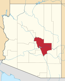 | |
| Towns | ||
| CDPs |
| |
| Unincorporated communities | ||
| Indian reservations | ||
| Ghost towns | ||
| Footnotes | ‡This populated place also has portions in an adjacent county or counties | |
This article is issued from Wikipedia - version of the 10/28/2016. The text is available under the Creative Commons Attribution/Share Alike but additional terms may apply for the media files.