East Verde Estates, Arizona
| East Verde Estates, Arizona | |
|---|---|
| Census-designated place | |
 East Verde Estates  East Verde Estates | |
| Coordinates: 34°17′54″N 111°21′52″W / 34.29833°N 111.36444°WCoordinates: 34°17′54″N 111°21′52″W / 34.29833°N 111.36444°W | |
| Country | United States |
| State | Arizona |
| County | Gila |
| Area[1] | |
| • Total | 2.504 sq mi (6.49 km2) |
| • Land | 2.504 sq mi (6.49 km2) |
| • Water | 0 sq mi (0 km2) |
| Elevation | 4,613 ft (1,406 m) |
| Population (2010) | |
| • Total | 170 |
| • Density | 68/sq mi (26/km2) |
| Time zone | Mountain (MST) (UTC-7) |
| Area code(s) | 928 |
| GNIS feature ID | 2582778[2] |
East Verde Estates is a census-designated place in Gila County in the state of Arizona. East Verde Estates is located about 6 miles north of the town of Payson off Arizona State Route 87. The population as of the 2010 U.S. Census was 170.[3]
Geography
East Verde Estates is located at 34°17′54″N 111°21′52″W / 34.298272°N 111.364552°W.
According to the U.S. Census Bureau, the community has an area of 2.504 square miles (6.49 km2), all of it land.[1]
References
- 1 2 "2010 Census Gazetteer Files: Places - Arizona". U.S. Census Bureau. Retrieved July 16, 2014.
- ↑ "East Verde Estates". Geographic Names Information System. United States Geological Survey.
- ↑ "2010 Census Interactive Population Search". census.gov. Retrieved 2014-04-17.
Municipalities and communities of Gila County, Arizona, United States | ||
|---|---|---|
| City | 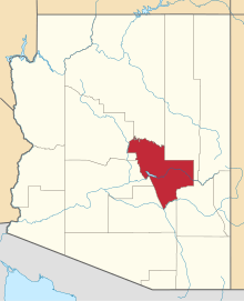 | |
| Towns | ||
| CDPs |
| |
| Unincorporated communities | ||
| Indian reservations | ||
| Ghost towns | ||
| Footnotes | ‡This populated place also has portions in an adjacent county or counties | |
This article is issued from Wikipedia - version of the 10/31/2016. The text is available under the Creative Commons Attribution/Share Alike but additional terms may apply for the media files.