Bluffdale, Utah
| Bluffdale, Utah | ||
|---|---|---|
| City | ||
|
Bluffdale Fire Station in 2013 | ||
| ||
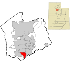 Location in Salt Lake County and the state of Utah. | ||
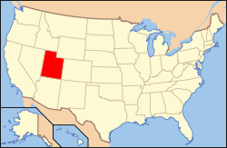 Location of Utah in the United States | ||
| Coordinates: 40°28′24″N 111°56′40″W / 40.47333°N 111.94444°WCoordinates: 40°28′24″N 111°56′40″W / 40.47333°N 111.94444°W | ||
| Country | United States | |
| State | Utah | |
| County | Salt Lake | |
| Founded | 1886 | |
| Named for | Bluffs (high cliffs) and dales (valleys) along the Jordan River | |
| Government | ||
| • Mayor | Derk Timothy | |
| • City Manager | Mark Reid | |
| Area | ||
| • Total | 10.22 sq mi (26.47 km2) | |
| • Land | 10.22 sq mi (26.47 km2) | |
| • Water | 0.0 sq mi (0.0 km2) | |
| Elevation | 4,436 ft (1,352 m) | |
| Population (2012)[1] | ||
| • Total | 7,975 | |
| • Density | 780/sq mi (300/km2) | |
| Time zone | MST (UTC-7) | |
| • Summer (DST) | MDT (UTC-6) | |
| ZIP code | 84065 | |
| Area code(s) | 385, 801 | |
| FIPS code | 49-06810 [2] | |
| GNIS feature ID | 1425844 [3] | |
| Website | bluffdale.com | |

Bluffdale is a city in Salt Lake and Utah counties in the U.S. state of Utah, located about 20 miles (32 km) south of Salt Lake City. As of the 2010 census, the city population was 7,598.[1]
From 2011 to 2013, the National Security Agency's (NSA) data storage center, the Utah Data Center, was constructed at Camp Williams in Bluffdale. It is approximately 1 million square feet in size.[4][5] Bluffdale is also home to the Granite Point data center.
History
Bluffdale, named for its geography of bluffs and dales, was first settled in 1848–1849 when the area was originally part of West Jordan. On July 29, 1858, Orrin Porter Rockwell paid five- hundred dollars to Evan M. Green for sixteen acres of land near to the Crystal Hot Lakes (adjacent to the present Utah State Prison). This land included a hotel with dining facilities, stable, brewery, and pony express station. As the community expanded, the Bluffdale area became part of South Jordan, then Riverton. In 1883 the Bluffdale School Precinct was formed from parts of Herriman, South Jordan and Draper. On August 1, 1886, the Bluffdale Ward of The Church of Jesus Christ of Latter-day Saints was organized with Lewis H. Mousley as Bishop. For a short time the town was called Mousley. There are seven irrigation canals that originate at the Jordan Narrows in the Bluffdale area and serve the Salt Lake Valley. One of the earliest was the Utah and Salt Lake Canal started in 1862. Some of the early buildings included an adobe church, built in 1887–1888, a tithing house, and a three-room schoolhouse constructed in 1893.[6]
Geography
According to the United States Census Bureau, the city has a total area of 10.22 square miles (26.47 km²), all of it land. Bluffdale is predominately located in Salt Lake County, though a portion of the city is located in Utah County. Bluffdale shares city borders with Herriman to the west, Riverton to the north, Draper to the east, and Lehi to the south.
Demographics
| Historical population | |||
|---|---|---|---|
| Census | Pop. | %± | |
| 1980 | 1,300 | — | |
| 1990 | 2,152 | 65.5% | |
| 2000 | 4,700 | 118.4% | |
| 2010 | 7,598 | 61.7% | |
| Est. 2015 | 10,931 | [7] | 43.9% |
| U.S. Decennial Census[8] | |||
Bluffdale is part of the Salt Lake City, Utah Metropolitan Statistical Area.
As of the census[2] of 2000, there were 4,700 people, 1,112 households, and 1,028 families residing in the city. The population density was 286.0 people per square mile (110.4/km²). There were 1,141 housing units at an average density of 69.4 per square mile (26.8/km²). The racial makeup of the city was 96.96% White, 0.23% African American, 0.28% Native American, 0.23% Asian, 0.26% Pacific Islander, 1.19% from other races, and 0.85% from two or more races. Hispanic or Latino of any race were 3.34% of the population.
There were 1,112 households out of which 61.0% had children under the age of 18 living with them, 86.1% were married couples living together, 3.9% had a female householder with no husband present, and 7.5% were non-families. Of all households 5.5% were made up of individuals and 2.5% had someone living alone who was 65 years of age or older. The average household size was 4.23 and the average family size was 4.39.
In the city the population was spread out with 41.3% under the age of 18, 10.1% from 18 to 24, 27.8% from 25 to 44, 16.2% from 45 to 64, and 4.6% who were 65 years of age or older. The median age was 23 years. For every 100 females there were 101.6 males. For every 100 females age 18 and over, there were 102.7 males.
The median income for a household in the city was US$66,615, and the median income for a family was $66,910. Males had a median income of $50,136 versus $23,469 for females. The per capita income for the city was $17,813. None of the families and 0.2% of the population were living below the poverty line, including no under eighteens and none of those over 64.
Economy
Camp Williams is located in Bluffdale.
Utah Data Center
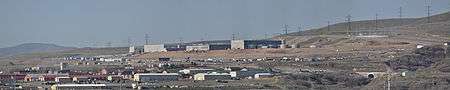
The Utah Data Center, also known as the Intelligence Community Comprehensive National Cybersecurity Initiative Data Center,[9] is a data storage facility for the United States Intelligence Community that is designed to be a primary storage resource capable of storing data on the scale of yottabytes (1 yottabyte = 1 trillion terabytes, or 1 quadrillion gigabytes).[10][11] Its purpose – as the name implies – is to support the Comprehensive National Cybersecurity Initiative (CNCI), including storing details of people's mobile phone and internet use, though its precise mission is secret.[12] The National Security Agency (NSA), which will lead operations at the facility, is the executive agent for the Director of National Intelligence.[13] It is located at Camp Williams.
The planned structure is 1 million or 1.5 million square feet[11][14][15] and cost $1.5 billion[16][17][18] when it was completed in May 2014.[10][11] One report suggested that it also cost another $2 billion for hardware, software, and maintenance.[11] The facility is estimated to have a power demand of 65 megawatts, costing about $40 million per year.[10][11]
See also
- Apostolic United Brethren – headquarters of this sect is in Bluffdale
- Utah State Prison located nearby
References
- 1 2 "2010 City Population and Housing Occupancy Status". U.S. Census Bureau. Archived from the original on July 21, 2011. Retrieved March 29, 2012.
- 1 2 "American FactFinder". United States Census Bureau. Archived from the original on 2013-09-11. Retrieved 2008-01-31.
- ↑ "US Board on Geographic Names". United States Geological Survey. 2007-10-25. Retrieved 2008-01-31.
- ↑ Bamford, James (March 15, 2012). "The NSA Is Building the Country's Biggest Spy Center (Watch What You Say)". Wired.
- ↑ Government is tracking all U.S. phone calls; LA Times; June 6, 2013.
- ↑ http://history.utah.gov/apps/markers/detailed_results.php?markerid=2113
- ↑ "Annual Estimates of the Resident Population for Incorporated Places: April 1, 2010 to July 1, 2015". Retrieved July 2, 2016.
- ↑ U.S. Decennial Census
- ↑ "NSA Utah Data Center". Facilities Magazine. 14 September 2011. Retrieved 24 April 2013.
- 1 2 3 Bamford, James (15 March 2012). "The NSA Is Building the Country's Biggest Spy Center (Watch What You Say)". Wired Magazine. Retrieved 5 April 2012.
- 1 2 3 4 5 Kenyon, Henry (Jan 7, 2011). "New NSA data center breaks ground on construction – Defense Systems". Defense Systems. Retrieved 11 August 2011.
- ↑ Fidel, Steve (6 Jane 2011). "Utah's $1.5 billion cyber-security center under way". Deseret News. Retrieved 29 March 2013. Check date values in:
|date=(help) - ↑ "U.S. agency denies data center to monitor citizens' emails". Reuters. 15 April 2013. Retrieved 16 April 2013.
- ↑ "NSA to store yottabytes in Utah data centre". CNET Networks. Retrieved 11 August 2011.
- ↑ Bamford, James. "Who's in Big Brother's Database? by James Bamford". The New York Review of Books. Retrieved 11 August 2011.
- ↑ LaPlante, Matthew D. (July 2, 2009). "New NSA center unveiled in budget documents". Salt Lake Tribune. MediaNews Group. Retrieved 2009-07-05.
- ↑ LaPlante, Matthew D. (July 2, 2009). "Spies like us: NSA to build huge facility in Utah". Salt Lake Tribune. MediaNews Group. Retrieved 2009-07-05.
- ↑ Fidel, Steve. "Utah's $1.5 billion cyber-security center under way". Deseret News. Retrieved 6 January 2011.
External links
| Wikimedia Commons has media related to Bluffdale, Utah. |
 |
Riverton | Draper | | |
| Herriman | |
|||
| ||||
| | ||||
| |
Saratoga Springs | Lehi |
Municipalities and communities of Salt Lake County, Utah, United States | ||
|---|---|---|
| Cities | 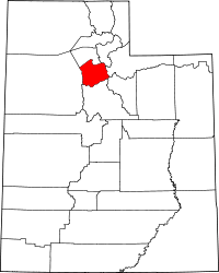 | |
| Town | ||
| Townships | ||
| CDPs | ||
| Unincorporated community | ||
| Ghost towns | ||
| Footnotes | ‡This populated place also has portions in an adjacent county or counties | |
Municipalities and communities of Utah County, Utah, United States | ||
|---|---|---|
| Cities | 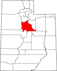 | |
| Towns | ||
| CDPs | ||
| Unincorporated communities | ||
| Indian reservation | ||
| Ghost towns | ||
| Footnotes | ‡This populated place also has portions in an adjacent county or counties | |