Blythe, California
| Blythe, California | ||
|---|---|---|
| City | ||
|
Blythe street scene, c. 1900 | ||
| ||
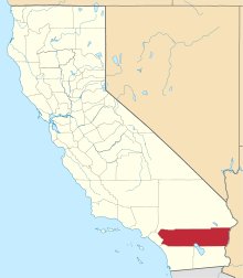
 Location in Riverside County and the state of California | ||
 Blythe, California Location in the United States | ||
| Coordinates: 33°36′37″N 114°35′47″W / 33.61028°N 114.59639°WCoordinates: 33°36′37″N 114°35′47″W / 33.61028°N 114.59639°W[1] | ||
| Country |
| |
| State |
| |
| County | Riverside | |
| Incorporated | July 21, 1916[2] | |
| Named for | Thomas H. Blythe | |
| Government | ||
| • Mayor | Joey DeConinck[3] | |
| Area[4] | ||
| • Total | 26.972 sq mi (69.855 km2) | |
| • Land | 26.189 sq mi (67.828 km2) | |
| • Water | 0.783 sq mi (2.027 km2) 2.90% | |
| Elevation[5] | 272 ft (83 m) | |
| Population (April 1, 2010)[6] | ||
| • Total | 20,817 | |
| • Estimate (2013)[6] | 19,832 | |
| • Density | 770/sq mi (300/km2) | |
| Time zone | PST (UTC-8) | |
| • Summer (DST) | PDT (UTC-7) | |
| ZIP codes | 92225, 92226 | |
| Area code | 442/760 | |
| FIPS code | 06-07218 | |
| GNIS feature IDs | 1660349, 2409872 | |
| Website |
www | |

.jpg)
Blythe /ˈblaɪθ/ is a city in Riverside County, California, United States, in the Palo Verde Valley of the Lower Colorado River Valley region, an agricultural area and part of the Colorado Desert along the Colorado River. Blythe was named after Thomas H. Blythe, a San Francisco financier, who established primary water rights to the Colorado River in the region in 1877. The city was incorporated on July 21, 1916. The population was 20,817 at the 2010 census.
History
In the early or mid-1870s, William Calloway (known as Oliver Calloway in some sources), an engineer and a former captain of the 1st California Infantry Regiment, explored an area across the Colorado River from Ehrenberg, Arizona and found its potential for development. Calloway made preliminary surveys and filed land claims under the Swamp Land Act of 1850. He interested the wealthier Thomas Henry Blythe (real last name Williams), who was born in Mold, Wales, to undertake development and settlement of an "empire" located next to the Colorado. On July 17, 1877, Blythe filed his first claim for Colorado River water on what was to become the "Blythe Intake".[7][8][9][10] Blythe appointed another man named George Irish as manager to assist Calloway in building an irrigation system. Calloway died in a Chemehuevi attack in March 28, 1880, and was replaced by C.C. Miller, the father of Frank Augustus Miller.[11][12] Thomas Blythe died on April 4, 1883; his only revisit to the valley was in November 1882.[13][12] After his death, the work in the valley halted and Blythe's estate subsequently went into litigation between his illegitimate daughter Florence and other claimants. The California Supreme Court up to 1895, and the U.S. Supreme Court towards the 1900s, ruled that Florence was the holder of the estate, after several years of preceding rulings in favor of her and appeals against her in these courts.[14][12][8]
Frank Murphy and Ed Williams, who were involved on the cattle industry in southeastern Arizona, came to the area in 1904 and were convinced it was well-suited for cattle and farming. With the Hobson brothers from Ventura County, California, they bought Blythe's estate and formed the Palo Verde Land and Water Company.[13][15] During 1911-12, W.F. Holt, who helped develop nearby Imperial Valley, was the company's general manager.[16][17]
On August 8, 1916, the California Southern Railroad reached Blythe from the desert station of Rice, California, then known as Blythe Junction. It was later renamed to honor G.W. Rice, an engineer and superintendent of the railroad. The dramatic growth in the valley following this event attracted national attention. Production totals increased annually from virtually nothing to near $8,000,000 in few years, primarily from cotton and cotton seed shipped to the ports.[18] The lower cotton prices in 1920 ended this prosperous time. The Atchison, Topeka, and Santa Fe Railway began leasing the line in 1921 and acquired it in the end of 1942.[19][17]
The first automobile bridge over the Colorado River between Blythe and Ehrenberg was constructed in 1928 to replace a cable ferry service.[20] The bridge's successor was built in the early 1960s and it was expanded to four lanes and a pedestrian walkway in early 1974.[21][22]
In 1972, Interstate 10 was built through the city, replacing US 60 and the previously decommissioned US 70 in Hobsonway as the main thoroughfare.[23]
Geography and climate
Blythe is located near the California/Arizona border in the Colorado Desert section of the Sonoran Desert, at the junction of Interstate 10 and US 95. According to the United States Census Bureau, the city has a total area of 27.0 square miles (70 km2), of which 26.2 square miles (68 km2) is land and 0.8 square miles (2.1 km2) (2.90%) is water.
Nearby communities include Lost Lake and Vidal to the north, Ripley to the south, Desert Center to the west, and Ehrenberg, Arizona, to the east. Major cities in the region include Yuma (85 miles), Indio (95 miles), Phoenix (150 miles), San Bernardino (170 miles), Riverside (172 miles), and Las Vegas (200 miles). Blythe is within 4 hours via car of 10% of the United States’ population.
Blythe has a desert climate with very hot summers and mild winters. There are an average of 178.4 days with highs of 90 °F (32 °C) or higher. There are an average of 18.9 days with lows of 32 °F (0 °C) or lower. Until 2016, the record high temperature was 122 °F (50 °C) on July 7, 1920, and June 24, 1929. But on June 20, 2016, that long-standing record was shattered when Blythe reached 124 °F (51 °C). The record low temperature was 5 °F (−15 °C) on January 6, 1913. There are an average of 16 days with measurable precipitation. The wettest year was 1951 with 8.71 inches (22.1 cm) and the driest year was 1956 with .18 inches (0.46 cm). The most rainfall in one month was 6.00 inches (15.2 cm) in August 1951, which included the 24-hour record rainfall of 3.06 inches (7.8 cm) on August 27.[24]
At the airport, there are an average of 176.0 days with highs of 90 °F (32 °C) or higher. There are an average of 5.4 days with lows of 32 °F (0 °C) or lower. The record high temperature was 124 °F (51 °C) on June 20, 2016. The record low temperature was 20 °F (−7 °C) on January 8, 1971. There an average of 17 days with measurable precipitation. The wettest year was 1992 with 9.16 inches (23.3 cm) and the driest year was 1953 with .59 inches (1.5 cm). The most rainfall in one month was 5.92 inches (15.0 cm) in August 1951, which included the 24-hour record rainfall of 3.00 inches (7.6 cm) on August 26.[25]
Average seasonal temperatures:
| Climate data for Blythe, California | |||||||||||||
|---|---|---|---|---|---|---|---|---|---|---|---|---|---|
| Month | Jan | Feb | Mar | Apr | May | Jun | Jul | Aug | Sep | Oct | Nov | Dec | Year |
| Average high °F (°C) | 67 (19) |
73 (23) |
79 (26) |
87 (31) |
95 (35) |
105 (41) |
109 (43) |
107 (42) |
101 (38) |
89 (32) |
75 (24) |
66 (19) |
87.8 (31.1) |
| Average low °F (°C) | 40 (4) |
44 (7) |
48 (9) |
54 (12) |
62 (17) |
69 (21) |
77 (25) |
76 (24) |
69 (21) |
57 (14) |
45 (7) |
39 (4) |
56.7 (13.8) |
| Average precipitation inches (mm) | 0.51 (13) |
0.57 (14.5) |
0.34 (8.6) |
0.11 (2.8) |
0.07 (1.8) |
0.03 (0.8) |
0.18 (4.6) |
0.65 (16.5) |
0.55 (14) |
0.25 (6.4) |
0.22 (5.6) |
0.50 (12.7) |
3.98 (101.3) |
| Source: www.weather.com | |||||||||||||
Also notable is the geological history of Blythe – despite California's reputation for earthquakes, according to geologists Blythe has not had an earthquake centered in the city for over 500,000 years.[26]
Local features
Tourism is a major component of the local economy. Blythe is a stopover city with full services for travelers between any of the nearby regions, in particular the major cities of Los Angeles and Phoenix, since it is approximately midway between those two metropolitan areas. The winter months bring visitors avoiding the colder climates of the north, when the population of the area within 50 miles (80 km) of Blythe has been known to exceed 500,000.[26]
Con-Way freight has a large facility here. It is used mainly at night for cross dock operations, as there is seldom a need to make deliveries here.
Blythe also contains 24 churches, one library, two newspapers Palo Verde Valley Times The Desert Independent, two museums, two radio stations, three banks, a three-screen movie theater (now closed), one funeral home and an 18,500 sq ft (1,720 m2). recreation center. The area is popular with campers and hikers and has six parks, seven campgrounds, seven R.V. parks, 3 boat ramps onto the Colorado River, and an 18-hole public golf course.
Blythe hosts the Blythe Blue Grass Festival annually the third weekend of January.
Dove hunting is popular in Blythe. The hunting season starts at every September 1.
Demographics
| Historical population | |||
|---|---|---|---|
| Census | Pop. | %± | |
| 1920 | 1,622 | — | |
| 1930 | 1,020 | −37.1% | |
| 1940 | 2,355 | 130.9% | |
| 1950 | 4,089 | 73.6% | |
| 1960 | 6,023 | 47.3% | |
| 1970 | 7,047 | 17.0% | |
| 1980 | 6,805 | −3.4% | |
| 1990 | 8,428 | 23.9% | |
| 2000 | 12,155 | 44.2% | |
| 2010 | 20,817 | 71.3% | |
| Est. 2015 | 19,208 | [27] | −7.7% |
2010
The 2010 United States Census[29] reported that Blythe had a population of 20,817. The population density was 771.8 people per square mile (298.0/km2). The racial makeup of Blythe was 12,396 (59.5%) White (28.3% Non-Hispanic White),[30] 3,126 (15.0%) African American, 243 (1.2%) Native American, 319 (1.5%) Asian, 32 (0.2%) Pacific Islander, 4,045 (19.4%) from other races, and 656 (3.2%) from two or more races. Hispanic or Latino of any race were 11,068 persons (53.2%).
The Census reported that 12,972 people (62.3% of the population) lived in households, 82 (0.4%) lived in non-institutionalized group quarters, and 7,763 (37.3%) were institutionalized.
There were 4,513 households, out of which 1,972 (43.7%) had children under the age of 18 living in them, 1,995 (44.2%) were opposite-sex married couples living together, 855 (18.9%) had a female householder with no husband present, 344 (7.6%) had a male householder with no wife present. There were 396 (8.8%) unmarried opposite-sex partnerships, and 24 (0.5%) same-sex married couples or partnerships. 1,071 households (23.7%) were made up of individuals and 367 (8.1%) had someone living alone who was 65 years of age or older. The average household size was 2.87. There were 3,194 families (70.8% of all households); the average family size was 3.41.
The population was spread out with 4,157 people (20.0%) under the age of 18, 1,770 people (8.5%) aged 18 to 24, 7,332 people (35.2%) aged 25 to 44, 5,764 people (27.7%) aged 45 to 64, and 1,794 people (8.6%) who were 65 years of age or older. The median age was 38.0 years. For every 100 females there were 218.1 males. For every 100 females age 18 and over, there were 268.1 males.
There were 5,473 housing units at an average density of 202.9 per square mile (78.3/km2), of which 2,358 (52.2%) were owner-occupied, and 2,155 (47.8%) were occupied by renters. The homeowner vacancy rate was 4.0%; the rental vacancy rate was 10.3%. 6,913 people (33.2% of the population) lived in owner-occupied housing units and 6,059 people (29.1%) lived in rental housing units.
According to the 2010 United States Census, Blythe had a median household income of $48,327, with 16.1% of the population living below the federal poverty line.[30]
2000
As of the census[31] of 2000, there were 12,155 people, 4,103 households, and 2,974 families residing in the city. The population density was 501.5 people per square mile (193.6/km2). There were 4,891 housing units at an average density of 201.8 per square mile (77.9/km2). The racial makeup of the city was 55.4% White, 8.3% Black or African American, 1.4% Native American, 1.4% Asian, 0.2% Pacific Islander, 28.8% from other races, and 4.5% from two or more races. 45.8% of the population were Hispanic or Latino of any race.
There were 4,103 households out of which 41.4% had children under the age of 18 living with them, 50.0% were married couples living together, 16.6% had a female householder with no husband present, and 27.5% were non-families. 22.9% of all households were made up of individuals and 7.1% had someone living alone who was 65 years of age or older. The average household size was 2.91 and the average family size was 3.45.
In the city the population was spread out with 33.9% under the age of 18, 8.7% from 18 to 24, 28.4% from 25 to 44, 19.0% from 45 to 64, and 9.9% who were 65 years of age or older. The median age was 31 years. For every 100 females there were 99.2 males. For every 100 females age 18 and over, there were 97.0 males.
The median income for a household in the city was $35,324, and the median income for a family was $40,783. Males had a median income of $32,342 versus $26,671 for females. The per capita income for the city was $14,424. About 19.0% of families and 20.9% of the population were below the poverty line, including 24.9% of those under age 18 and 21.6% of those age 65 or over.
Politics
In the California State Legislature, Blythe is in the 40th Senate District represented by Democrat Denise Moreno Ducheny and, in the 56th Assembly District, represented by Democrat Eduardo Garcia.[32]
In the United States House of Representatives, Blythe is in California's 36th congressional district, represented by Democrat Raul Ruiz.[33]
Sports
- The Blythe Heat is a winter professional minor league baseball team of the Arizona Winter League, and also a member of the Arizona Summer League. They play on Alexander Field in Todd Park facing the Palo Verde College. Some games of the Lake Havasu Heat (folded in 2009) of the semi-pro Pacific Southwest Baseball League played in Blythe during the summer months.
Public services
State and federal agencies
State facilities in the town include the following:
- Resources Agency, California Department of Fish and Game office at 150 S. Main Street.
- California Highway Patrol office at 430 S. Broadway Street.
- California Department of Motor Vehicles office at 430 S. Broadway Street.
- California Department of Food and Agriculture office.
- California Department of Corrections and Rehabilitation-Chuckawalla Valley State Prison
- California Department of Corrections and Rehabilitation-Ironwood State Prison
Federal facilities in the town include the following:
- U.S. Border Patrol
- U.S. Department of Agriculture – Blythe Federal Building
- U.S. Postal Service – Blythe Federal Building
Safety
Blythe has its own police department and volunteer fire department. The Riverside County Sheriff's Department also has a regional station in Blythe.
Education
Blythe area public elementary and secondary schools comprise the Palo Verde Unified School District, which contains 3 elementary schools and 1 high school, and continuation/adult education school. Palo Verde Community College District is part of the California Community College system and includes Palo Verde Community College, a campus in Blythe, a center in Needles and an extension for Adult Basic education and non-credit classes located on Spring Street in downtown Blythe. As of 2012, there is one private non-profit school, The Desert Learning Center, for grades K-8.
Transportation
Interstate 10 crosses Blythe on an east-west direction. State Route 78's northern terminus is west of Blythe. U.S. Route 95 crosses Blythe in the eastern side. Lovekin Boulevard and Midland Road serves the ghost town of Midland.
Blythe Airport (BLH) is just west of the town on Interstate 10 and has a 6,500-foot (2,000 m) runway.
Blythe was served in rail by the Arizona and California Railroad but currently has no rail service since an embargo in late 2007 and abandonment in 2009.[34]
Blythe is served by Palo Verde Valley Transit Agency.[35] Greyhound stops in Blythe.[36]
Healthcare
Health facilities in Blythe include Palo Verde Hospital, a General Acute Care Hospital with 55 total beds and 24-hour standby emergency services, 23 physicians/surgeons, 2 dentists, 2 optometrists, 1 chiropractor, and 1 podiatrist.[37]
Cemetery
The Palo Verde Cemetery District[38] maintains the Palo Verde Cemetery.[39][40]
See also
References
- ↑ "Blythe". Geographic Names Information System. United States Geological Survey..
- ↑ "California Cities by Incorporation Date". California Association of Local Agency Formation Commissions. Archived from the original (Word) on November 3, 2014. Retrieved August 25, 2014.
- ↑ "New mayor appointed by Blythe City Council". Palo Verde Valley Times. 2015-07-15. Retrieved 2015-12-19.
- ↑ "2010 Census U.S. Gazetteer Files – Places – California". United States Census Bureau.
- ↑ "Blythe". Geographic Names Information System. United States Geological Survey. Retrieved October 20, 2014.
- 1 2 "Blythe (city) QuickFacts". United States Census Bureau. Retrieved February 22, 2015.
- ↑ An historical marker for the intake was placed by the Palo Verde Valley Historical Society and Riverside County Parks and Recreation in 1986. Johnson, Marael (1995). Why Stop? A Guide to California Roadside Historical Markers. Houston, TX: Gulf Publishing Company. p. 213. ISBN 9780884159230. OCLC 32168093.
- 1 2 Blythe resided in San Francisco and focused in real estate investments. Among his investments was a patch of undeveloped land within what is now downtown San Francisco. Development in the purchased site within Market Street, Geary Street, and Grant Street, called the "Blythe Block", and being in the center of downtown, made Blythe wealthy. The Blythe Block was sold off in portions in 1901 and 1902. http://www.sandiegohistory.org/journal/71summer/desert.htm
- ↑ "Blythe Block Changes Hands". San Francisco Call. 1901-08-02.
- ↑ "Blythe Block Sold". Los Angeles Herald. 1902-01-07. p. 1.
- ↑ Roth, George (1977). "The Calloway Affair of 1880: Chemehuevi Adaptation and Chemehuevi-Mohave Relations". Journal of California Anthropology. 4 (2).
- 1 2 3 Woodward, Arthur (1939). "Empire on the Colorado". Desert Magazine. El Centro. 2 (4): 22–24 39–40.
- 1 2 "Palo Verde Irrigation District History". Palo Verde Irrigation District. February 2005. Retrieved 11 February 2015.
- ↑ John Boessenecker (1998). Lawman: The Life and Times of Harry Morse, 1835–1912. University of Oklahoma Press. pp. 265–266. ISBN 978-0-8061-3011-8.
- ↑ Paul Lincoln Kleinsorge (1 January 1941). The Boulder Canyon Project, Historical and Economic Aspects. Stanford University Press. p. 35. ISBN 978-0-8047-1031-2.
- ↑ "Developing Palo Verde". Imperial Valley Press. 11 March 1911. Retrieved 11 February 2015.
- 1 2 David F. Myrick (2001). Santa Fe to Phoenix: Railroads of Arizona. Signature Press. ISBN 978-1-930013-05-6.
- ↑ "California Southern Extended to Open New District". The Santa Fe Magazine. April 1920. p. 60.
- ↑ Donald B. Robertson (1986). Encyclopedia of Western Railroad History: California. Caxton Press. p. 95. ISBN 978-0-87004-385-7.
- ↑ California Highways and Public Works. Department of Public Works, State of California. 1933. p. 22.
- ↑ California Highways and Public Works. Department of Public Works, State of California. 1960. p. 34.
- ↑ "Bridge project finished". Palo Verde Valley Times. 1974-03-07.
- ↑ Front page picture in the Palo Verde Valley Times, October 26, 1972.
- ↑ http://www.wrcc.dri.edu/cgi-bin/cliMAIN.pl?ca0924
- ↑ http://www.wrcc.dri.edu/cgi-bin/cliMAIN.pl?ca0927
- 1 2 About Blythe, Ca
- ↑ "Annual Estimates of the Resident Population for Incorporated Places: April 1, 2010 to July 1, 2015". Retrieved July 2, 2016.
- ↑ "Census of Population and Housing". Census.gov. Archived from the original on May 11, 2015. Retrieved June 4, 2015.
- ↑ "2010 Census Interactive Population Search: CA – Blythe city". U.S. Census Bureau. Retrieved July 12, 2014.
- 1 2 http://quickfacts.census.gov/qfd/states/06/0607218.html. Missing or empty
|title=(help) - ↑ "American FactFinder". United States Census Bureau. Archived from the original on 2013-09-11. Retrieved 2008-01-31.
- ↑ "Statewide Database". UC Regents. Retrieved November 23, 2014.
- ↑ "California's 36th Congressional District - Representatives & District Map". Civic Impulse, LLC.
- ↑ "SURFACE TRANSPORTATION BOARD DECISION". Retrieved 2016-05-02.
- ↑ Palo Verde Valley Transit Agency
- ↑ Greyhound
- ↑ California Department of Health Services
- ↑ California Association of Public Cemeteries
- ↑ 33°37′51″N 114°36′03″W / 33.6308572°N 114.6007904°W USGS Geographic Names Information System (GNIS)
- ↑ Palo Verde Cemetery Find A Grave
External links
| Wikivoyage has a travel guide for Blythe. |
 |
Eagle Mountains | Big Maria Mountains | Parker Valley | |
| Desert Center, California | |
Colorado River Dome Rock Mountains, Arizona | ||
| ||||
| | ||||
| Palo Verde Mesa | Cibola Valley | Trigo Mountains, Arizona |