Border irregularities of the United States
Border irregularities of the United States, particularly panhandles and highway incursions into other jurisdictions, are shown here. Often they are a result of borders which do not conform to geological features.
International
Canada
There are several exclaves between the United States and Canada, including the entire state of Alaska. Other exclaves include the Northwest Angle, Point Roberts and Akwesasne.
The status of the waters around Nunez Rocks is disputed. Nunez Rocks is a low-tide elevation ("bare at half-tide"[1]) area (LTE) that is south of a line known as the "A-B" Line,[2] which was defined in a 1903 arbitration decision on the Alaska–Canada boundary.[3] The court specified the initial boundary point (Point "A") at the northern end of Dixon Entrance[4] and Point "B" 72 nautical miles (83 mi; 133 km) to the east.[5] Canada relies on the "A-B" Line as rendering nearly all of Dixon Entrance as Canadian internal waters. The U.S. does not recognize the "A-B" Line as an official boundary, instead regarding it as allocating sovereignty over the land masses within the Dixon Entrance,[2] with Canada's land south of the line. The U.S. regards the waters as subject to international marine law, and in 1977 it defined an equidistant territorial sea throughout Dixon Entrance.[2] This territory, which surrounds Nunez Rocks, extends south of the "A-B" line for the most part.[2] The United States has not ratified the Law of the Sea Treaty, although it adheres to most of its principles as customary international law. Under the treaty, LTEs may be used as basepoints for a territorial sea, and the U.S. uses Nunez Rocks as a basepoint. As a non-signatory, however, there is nothing preventing the U.S. from claiming areas beyond the scope of the Law of the Sea Treaty. The fact remains that, for about half of each day, above-water territory that Canada regards as Canadian is surrounded by sea territory that the U.S. has declared to be American.
Mexico
In Texas and Mexico, shifts in the course of the lower Rio Grande have created numerous pene-exclaves. Under the Boundary Treaty of 1970 and earlier treaties, the United States and Mexico have maintained the actual course of the river as the international boundary, but both must approve proposed changes. From 1989 to 2009, there were 128 locations where the river changed course, causing land that had been on one side of the river to then occupy the opposite bank. Until the boundary is officially changed, there are 60 small pene-exclaves of the state of Texas now lying on the southern side of the river, as well as 68 such pene-exclaves of Mexico on the northern side of the river.
Russia
The legal status of the US-Russian border is unclear. The United States Senate ratified a treaty setting the boundary with the Soviet Union in 1991. However, shortly after, the Soviet Union collapsed, and the Russian parliament never voted on the treaty.
Cuba
The boundary between the United States and Cuba is a maritime boundary along the Straits of Florida. Despite tense relations between the countries, the United States operates a military base in Cuba, Guantanamo Bay.
States
Separated by the Mississippi River or other river changes from the 1812 New Madrid earthquake:
- Tennessee's Reverie and Corona, located in Tipton County north-northwest of Memphis.[6]
Other irregularities involving the Mississippi River:
- Arkansas has territory at 35°39′N 89°52′W / 35.65°N 89.87°W across the Mississippi River on the northwest edge of Tennessee's Fort Pillow State Park, north of the Corona/Reverie, Tennessee irregularity (mentioned in the previous section).
- Illinois' Kaskaskia, Missouri's Grand Tower Island and other Illinois and Missouri territory on each other's side of the Mississippi River.
- The Kentucky Bend between Missouri and Tennessee.
Separated by water other than the Mississippi River:
- Rosecrans Memorial Airport, though lying within the city limits of St. Joseph, Missouri, is inaccessible by land from Missouri due to a change in the course of the Missouri River following the Great Flood of 1951. It is accessible only by crossing the river, then turning north through Elwood, Kansas.
- Delaware has two exclaves of land on the New Jersey side of Delaware Bay northwest of Fort Mott State Park and Killcohook National Wildlife Refuge: Finns Point and Artificial Island, Delaware near the Salem Nuclear Power Plant in Salem County, New Jersey. At that point, the border runs along New Jersey's mean low-tide mark. Thus when the spoils from the navigational dredging of the bay were dumped alongside Fort Mott and the Salem plant excavations nearby, both sites became part of New Castle County, Delaware.
- Iowa's city of Carter Lake on the Nebraska side of the Missouri River.
- Several small areas of western Kentucky lie north of the Ohio River on what is otherwise the Indiana side, including one area south of Evansville, Indiana that accommodates a horse racing track.
- Several portions of Nebraska lie east of the Missouri River, mainly due to flooding and changes in the river's path:
- DeSoto National Wildlife Refuge near Blair, which borders Iowa. A portion of Iowa is also on the Nebraska side in the same area.
- McKissick Island near Peru, which borders Missouri.
- A section of land that borders Iowa, Sloan.
- Onawa Materials Yard Wildlife Area and Middle Decatur Bend State Wildlife Management Area near Onawa, Iowa.
- The Eastern Shore of Virginia is separated by the Chesapeake Bay from the rest of the Commonwealth.
- Divided coastal islands:
- Rhode Island and Connecticut share Sandy Point Island in Little Narragansett Bay.
- New Jersey and New York share Shooter's Island, a bird sanctuary located in the south end of Newark Bay off the north shore of Staten Island. (The small portion in New Jersey is further divided between two counties.)
- Delaware and Maryland share Fenwick Island.
- Maryland and Virginia share Smith Island in Chesapeake Bay, as well as Assateague Island on the Atlantic coast.
- Virginia and North Carolina share Knotts Island, Mon Island and Simon Island, separated from the Atlantic by an intracoastal waterway.
- North Carolina and South Carolina share Bird Island on the Atlantic coast.
- Florida and Alabama share Perdido Key in the Gulf of Mexico.
- Alabama and Mississippi share South Rigolets Island in the Gulf of Mexico.
- Alabama and Mississippi share an island between Bayou Heron and Mattie Clark Bayou on the Gulf Coast.
- Minnesota and Wisconsin share Interstate Island State Wildlife Management Area in Saint Louis Bay between Duluth, Minnesota, and Superior, Wisconsin.
- Michigan and Ohio share Turtle Island in Lake Erie.
- At the mouth of the Columbia River, Oregon and Washington share Sand Island Dike and Rice Island.[7]
Other irregularities:
- The Delaware Wedge adjacent to Maryland and Pennsylvania[8]
- The Erie Triangle.
- Michigan's Lost Peninsula Marina and neighboring Erie Township north of Toledo and Washington Township, Lucas County, Ohio; resulting from Toledo War border realignment.
- Massachusetts' Southwick Jog.
- Missouri's Bootheel.
- The above-water portion of Liberty Island is part of New York State, but being located in New York Bay, is entirely surrounded by the waters of New Jersey. Ellis Island is also in the waters of New Jersey, but the naturally formed part of the island belongs to New York, while the artificial infill portion surrounding it belongs to New Jersey. The original land area of Ellis Island is a true exclave of New York State.

Highway system irregularities
- Oklahoma State Highway 20 forms a concurrency with Arkansas Highway 43 between Maysville, Arkansas and the Missouri state line, where AR-43 becomes Missouri Highway 43.
- Interstate 24 briefly enters Georgia for a few miles but comes back into Tennessee, and retains Tennessee exit numbers, but not Tennessee mile markers.
- Minnesota State Highway 23 enters Wisconsin near Duluth for half a mile.
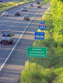
- Interstate 684, otherwise in New York, takes a shortcut across the northwest corner of the Connecticut Panhandle without any exits or signage save a standard Connecticut sign welcoming travelers to Greenwich.
- Interstate 86, formerly NY 17, drops just south of the Pennsylvania state line for two miles between Waverly and Sayre. The crossing is indicated by signs in both directions, but the New York signage and exit numbering remain (prior to being converted to an interstate, Route 17's sequential exit numbering began at its Pennsylvania terminus and continued into New York, one of the few highways in the U.S. where this was so; however, it is not uncommon for state highways to retain their route numbers when they change state highway shields at the border).
- New York State Route 120A runs along the Connecticut state line for much of its length, apart from 3.6 miles that enter the state, yet retains its New York signage and is still maintained by the New York State Department of Transportation.
- Montana State Highway 43 runs for approximately one mile inside Idaho, between Chief Joseph Pass and Lost Trail Pass. It crosses into Montana again just yards from its junction with US 93.
- The Woodrow Wilson Bridge carries I-95 and I-495 (the Capitol Beltway) across the Potomac River south of the District of Columbia. It connects Maryland on the east shore of the river with Virginia on the west shore. However, a few hundred feet of roadway close to the Virginia side crosses the southernmost point of the District of Columbia and thus is in neither Maryland nor Virginia.
- 13 miles of Pennsylvania Route 426 goes through New York, though unlike other state highways on the list that briefly enter other states with their normal symbols, this one is badged as New York State Route 426 between both borders of Pennsylvania.
Highway exclaves
Some highways are not connected to the rest of their nominal highway systems:
- In addition to Alaska and Hawaii being separated from the Lower 48, each has road systems isolated from each other. Alaska Route 7 and the other roads near Juneau, Alaska remain separated by ferry from other road systems.
- Iowa Highway 165 in Carter Lake, Iowa, is the only state highway in Iowa to be entirely west of the Missouri River. The highway is the middle span of the Omaha, Nebraska road named Abbott Drive, and is not directly connected to any other street. The rest of Carter Lake is a separate street system exclave accessible only from Locust Street or Avenue H in Omaha.
- M-185 is a state highway in Michigan. Like the rest of Mackinac Island, M-185 is prohibited to motor vehicles except for emergency vehicles.
- In Atchison County, Missouri, Missouri supplemental route V is separated from the rest of Missouri's highway system. It connects only to roads in Fremont County, Iowa. This is due to lying northwest of the Nishnabotna River.
- New York State Route 171, near Utica, does not intersect any other state highways (it once did, with NY 5S, but a realignment of that route took it away from the one intersection that NY 171 had).
- New Jersey Route 324 is an isolated route in Logan Township, New Jersey that connects to the former docks of a ferry on the Delaware River carrying US Route 322 to Chester, Pennsylvania. The ferry was replaced by the Commodore Barry Bridge in 1974. Route 324 used to connect to New Jersey Route 44 at its eastern end prior to a realignment.
- A bridge connecting to Pond Eddy, Pennsylvania across the Delaware River to New York State is owned by Pennsylvania, despite having no connection to the rest of Pennsylvania's road network. One must use New York Route 97 to cross back over the river at Narrowsburg, New York or Port Jervis, New York, a distance of approximately 14 miles (23 km). When the original bridge needed replacement, Pennsylvania had considered buying out the property owners and demolishing the town and the bridge. (Bridges over the Delaware River between the two states are maintained by a joint commission operated by the transportation departments of both states.)
References
- ↑ U.S. National Geodetic Survey. "NOAA Shoreline Data Explorer". Retrieved 2015-04-10.
- 1 2 3 4 Gray, David H. (Autumn 1997). "Canada's Unresolved Maritime Boundaries" (PDF). IBRU Boundary and Security Bulletin. p. 61. Retrieved 2015-03-21.
- ↑ "International Boundary Commission definition of the Canada/US boundary in the NAD83 CSRS reference frame". Retrieved 2015-03-21.
- ↑ White, James (1914). Boundary Disputes and Treaties. Toronto: Glasgow, Brook & Company. pp. 936–958.
- ↑ Davidson, George (1903). The Alaska Boundary. San Francisco: Alaska Packers Association. pp. 79–81, 129–134, 177–179, 229.
- ↑ "Tipton". Tennessee History for Kids. Nashville, Tennessee: Tennessee History for Kids. 2010-01-18. Retrieved 2010-04-20.
- ↑ Lewis and Clark and Julia Butler Hansen National Wildlife Refuges Draft CCP/EIS Chapter 2. Alternatives, Goals, Objectives, and Strategies (PDF). Washington, DC: United States Fish and Wildlife Service. pp. 2–27. Retrieved 2016-04-20.
- ↑ .Whong, Christopher M. (2000-12-11). "The Boundary Disputes of Colonial Maryland". Baltimore, Maryland. Retrieved 2010-04-20.