Carter Lake, Iowa
| Carter Lake, Iowa | |
|---|---|
| City | |
|
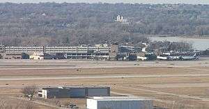
Carter Lake is across the road from Eppley Airport | |
 Location of Carter Lake, Iowa | |
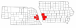
 U.S. Census Map | |
| Coordinates: 41°17′34″N 95°54′50″W / 41.29278°N 95.91389°WCoordinates: 41°17′34″N 95°54′50″W / 41.29278°N 95.91389°W | |
| Country |
|
| State |
|
| County | Pottawattamie |
| Government | |
| • Type | Mayor-council |
| Area[1] | |
| • Total | 2.02 sq mi (5.23 km2) |
| • Land | 1.87 sq mi (4.84 km2) |
| • Water | 0.15 sq mi (0.39 km2) |
| Elevation | 981 ft (299 m) |
| Population (2010)[2] | |
| • Total | 3,785 |
| • Estimate (2012[3]) | 3,765 |
| • Density | 2,024.1/sq mi (781.5/km2) |
| Time zone | Central (CST) (UTC-6) |
| • Summer (DST) | CDT (UTC-5) |
| ZIP code | 51510 |
| Area code(s) | 712 |
| FIPS code | 19-11215 |
| GNIS feature ID | 0455192 |
| Website | City Website |
Carter Lake is a city in Pottawattamie County, Iowa, United States. The population was 3,785 at the 2010 census.
History
Carter Lake is the only city in Iowa located west of the Missouri River. This is due to a flood that occurred in March 1877, which redirected the course of the river 1.25 mi (2 km) to the southeast. The remnants of the old river course, called Saratoga Bend, became an oxbow lake, Carter Lake, for which the town is named today.
Soon after the formation of the lake, the site became a flourishing recreational area. It included, "a boathouse at the foot of Locust street, hotels and club houses were numerous and the lake was the scene of many a pleasant rowing and fishing party."[4]
After extensive litigation between Iowa and Nebraska, in 1892 the Supreme Court of the United States finally ruled that Carter Lake belonged to Iowa in Nebraska v. Iowa, 143 U.S. 359 (1892).[5] Although the general rule is that state boundaries follow gradual changes in the course of a river, the Court ruled that an exception exists when a river avulses one of its bends. In 1972, the Supreme Court made another ruling on the circumstances of Carter Lake when it ruled on a boundary dispute between the two states in Nebraska v. Iowa, 406 U.S. 117 (1972).[6]
Although Carter Lake was legally considered part of Council Bluffs, residents lacked the basic city services enjoyed by residents east of the Missouri but were still subject to city taxes. The community successfully seceded from Council Bluffs in the 1920s, intending to become part of Omaha, Nebraska but that city did not want to pay to extend sewers or water lines either. In 1930, Carter Lake was incorporated as its own municipality.
During the late 1930s and 1940s, the Chez Paree nightclub and casino operated openly in Carter Lake because casinos were legal in Iowa even though illegal in Nebraska. Consequently, Carter Lake gained the reputation as the biggest gambling spot between Chicago and Reno.
A mistaken belief that a defendant corporation located in Carter Lake was a legal resident of Nebraska resulted in another U.S. Supreme Court case, Owen Equipment & Erection Co. v. Kroger, 437 U.S. 365 (1978). This case clarified the law regarding ancillary jurisdiction, which allows claims based on state law to be heard in a federal court when related to a claim based on federal law.
Carter Lake creates a geographic oddity for travelers going to Eppley Airfield, which it surrounds on the south and west. Consequently, travelers going to Eppley Airfield from anywhere except North Omaha will be going through Carter Lake, Iowa. It has caused great confusion when travelers not used to the area go through and see a "Welcome to Iowa" sign on their way to and from the airport.
Geography
Carter Lake is located at 41°17′34″N 95°54′50″W / 41.29278°N 95.91389°W (41.292647, -95.913989).[7]
The city is surrounded on three sides by Omaha, Nebraska and on the fourth by the Missouri River.
According to the United States Census Bureau, the city has a total area of 2.02 square miles (5.23 km2), of which, 1.87 square miles (4.84 km2) is land and 0.15 square miles (0.39 km2) is water.[1]
Demographics
| Historical populations | ||
|---|---|---|
| Year | Pop. | ±% |
| 1940 | 846 | — |
| 1950 | 1,183 | +39.8% |
| 1960 | 2,287 | +93.3% |
| 1970 | 3,268 | +42.9% |
| 1980 | 3,438 | +5.2% |
| 1990 | 3,200 | −6.9% |
| 2000 | 3,248 | +1.5% |
| 2010 | 3,785 | +16.5% |
| 2015 | 3,791 | +0.2% |
| Source:"American FactFinder". United States Census Bureau. and Iowa Data Center Source: | ||
2010 census
As of the census[2] of 2010, there were 3,785 people, 1,388 households, and 997 families residing in the city. The population density was 2,024.1 inhabitants per square mile (781.5/km2). There were 1,481 housing units at an average density of 792.0 per square mile (305.8/km2). The racial makeup of the city was 90.3% White, 1.0% African American, 0.8% Native American, 0.5% Asian, 5.8% from other races, and 1.6% from two or more races. Hispanic or Latino of any race were 11.5% of the population.
There were 1,388 households of which 37.4% had children under the age of 18 living with them, 46.5% were married couples living together, 17.9% had a female householder with no husband present, 7.4% had a male householder with no wife present, and 28.2% were non-families. 22.3% of all households were made up of individuals and 8.2% had someone living alone who was 65 years of age or older. The average household size was 2.73 and the average family size was 3.16.
The median age in the city was 36.1 years. 28.3% of residents were under the age of 18; 8.3% were between the ages of 18 and 24; 25.1% were from 25 to 44; 25.5% were from 45 to 64; and 12.8% were 65 years of age or older. The gender makeup of the city was 49.4% male and 50.6% female.
2000 census
As of the census[9] of 2000, there were 3,248 people, 1,221 households, and 914 families residing in the city. The population density is 1,799.7 people per square mile (696.7/km²). There were 1,292 housing units at an average density of 715.9 per square mile (277.1/km²). The racial makeup of the city was 96.71% White, 0.25% African American, 0.74% Native American, 0.25% Asian, 0.86% from other races, and 1.20% from two or more races. 2.89% of the population were Hispanic or Latino of any race.

There were 1,221 households out of which 32.3% have children under the age of 18 living with them, 55.4% were married couples living together, 13.3% had a female householder with no husband present, and 25.1% were non-families. 20.1% of all households were made up of individuals and 7.5% had someone living alone who was 65 years of age or older. The average household size was 2.66 and the average family size was 3.04.
Age/Gender Breakdown: 25.9% under the age of 18, 8.0% from 18 to 24, 29.8% from 25 to 44, 24.3% from 45 to 64, and 12.0% who were 65 years of age or older. The median age was 37 years. For every 100 females there were 100.1 males. For every 100 females age 18 and over, there were 94.4 males.
The median income for a household in the city was $37,851, and the median income for a family was $42,794. Males had a median income of $30,946 versus $23,309 for females. The per capita income for the city was $18,758. 7.1% of the population and 4.9% of families were below the poverty line. Out of the total population, 11.6% of those under the age of 18 and 2.9% of those 65 and older were living below the poverty line.
See also
References
- 1 2 "US Gazetteer files 2010". United States Census Bureau. Archived from the original on 2012-07-14. Retrieved 2012-05-11.
- 1 2 "American FactFinder". United States Census Bureau. Retrieved 2012-05-11.
- ↑ "Population Estimates". United States Census Bureau. Archived from the original on 2013-06-17. Retrieved 2013-05-23.
- ↑ 1890. "The Rise and Fall of Cut-Off Lake" from the Omaha Bee.
- ↑ "Nebraska v. Iowa", 143 U.S. 359 (1892).
- ↑ Nebraska v. Iowa, 406 U.S. 117 (1972).
- ↑ "US Gazetteer files: 2010, 2000, and 1990". United States Census Bureau. 2011-02-12. Retrieved 2011-04-23.
- ↑ "Census of Population and Housing". Census.gov. Archived from the original on April 22, 2013. Retrieved June 4, 2015.
- ↑ "American FactFinder". United States Census Bureau. Archived from the original on 2013-09-11. Retrieved 2008-01-31.
External links
| Wikimedia Commons has media related to Carter Lake, Iowa. |
- City of Carter Lake
- History of Carter Lake
- Edward F. Owen Memorial Library
- Carter Lake Elementary School
- Carter Lake Community Resource Center
- Carter Lake Preservation Society
- Carter Lake Weather
- Map showing history of Missouri River shifts at Carter Lake
- City-Data Comprehensive Statistical Data and more about Carter Lake
Municipalities and communities of Pottawattamie County, Iowa, United States | ||
|---|---|---|
| Cities | ||
| Townships | ||
| CDPs | ||
| Other community | ||
| Footnotes | ‡This populated place also has portions in an adjacent county or counties | |
Metropolitan area of Omaha–Council Bluffs | ||||||||
|---|---|---|---|---|---|---|---|---|
| Primary Cities |
|  | ||||||
| Cities over 10,000 (per 2010 Census) |
| |||||||
| Cities of 5,000 to 10,000 (per 2010 Census) |
| |||||||
| Cities of 1,000 to 5,000 (per 2010 Census) |
| |||||||
| Census-designated places |
| |||||||
| Cities and villages of fewer than 1,000 (per 2010 Census) |
| |||||||
| Counties |
| |||||||