Bozel
| Bozel | |
|---|---|
|
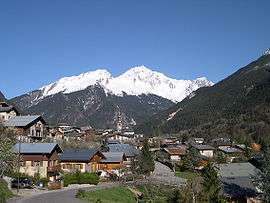
The church and surrounding buildings in Bozel | |
 Bozel | |
|
Location within Auvergne-Rhône-Alpes region  Bozel | |
| Coordinates: 45°27′08″N 6°38′56″E / 45.4522°N 6.6488°ECoordinates: 45°27′08″N 6°38′56″E / 45.4522°N 6.6488°E | |
| Country | France |
| Region | Auvergne-Rhône-Alpes |
| Department | Savoie |
| Arrondissement | Albertville |
| Canton | Bozel |
| Intercommunality | Val Vanoise |
| Government | |
| • Mayor (2008–2014) | Christian Seigle-Ferrand |
| Area1 | 28.8 km2 (11.1 sq mi) |
| Population (2006)2 | 2,031 |
| • Density | 71/km2 (180/sq mi) |
| Time zone | CET (UTC+1) |
| • Summer (DST) | CEST (UTC+2) |
| INSEE/Postal code | 73055 / 73350 |
| Elevation |
746–2,589 m (2,448–8,494 ft) (avg. 768 m or 2,520 ft) |
| Website | www.ot-bozel.com, www.bozelinfo.com |
|
1 French Land Register data, which excludes lakes, ponds, glaciers > 1 km² (0.386 sq mi or 247 acres) and river estuaries. 2 Population without double counting: residents of multiple communes (e.g., students and military personnel) only counted once. | |
Bozel is a commune in the Savoie department in the Auvergne-Rhône-Alpes region in south-eastern France.
Bozel has one surface ski lift and a green run. It also boasts 19 km of cross-country trails.
See also
References
External links
| Wikimedia Commons has media related to Bozel. |
 Bozel travel guide from Wikivoyage
- Official site
This article is issued from Wikipedia - version of the 11/6/2016. The text is available under the Creative Commons Attribution/Share Alike but additional terms may apply for the media files.