Bradford, New York
| Bradford, New York | |
|---|---|
| Town | |
 Bradford, New York Location within the state of New York | |
| Coordinates: 42°19′51″N 77°8′0″W / 42.33083°N 77.13333°W | |
| Country | United States |
| State | New York |
| County | Steuben |
| Area | |
| • Total | 24.9 sq mi (64.4 km2) |
| • Land | 24.8 sq mi (64.3 km2) |
| • Water | 0.0 sq mi (0.1 km2) |
| Elevation | 1,316 ft (401 m) |
| Population (2000) | |
| • Total | 763 |
| • Density | 30.7/sq mi (11.9/km2) |
| Time zone | Eastern (EST) (UTC-5) |
| • Summer (DST) | EDT (UTC-4) |
| FIPS code | 36-07740 |
| GNIS feature ID | 0978747 |
Bradford is a town in Steuben County, New York, United States. The population was 763 at the 2000 census. The town is named after Major Robert Bradford.
The Town of Bradford is in the northeast part of the county, north of Corning, New York.
History
The town was first settled around 1793.First settler was Daniel Taylor. (b.1775 d.Dec.3,1851)int.sonora,N.Y. cemetery,
The town was formed from the Town of Orange (then the "Town of Jersey") in Schuyler County in 1836.
Geography
According to the United States Census Bureau, the town has a total area of 24.9 square miles (64 km2), of which, 24.8 square miles (64 km2) of it is land and 0.04 square miles (0.10 km2) of it (0.16%) is water.
The east town line is the border of Schuyler County (Town of Orange). A part of Lamoka Lake, called Mill Pond is within the east town line.
New York State Route 226 traverses the town from east-to-west.
Demographics
| Historical population | |||
|---|---|---|---|
| Census | Pop. | %± | |
| 1840 | 1,547 | — | |
| 1850 | 2,010 | 29.9% | |
| 1860 | 1,211 | −39.8% | |
| 1870 | 1,080 | −10.8% | |
| 1880 | 937 | −13.2% | |
| 1890 | 765 | −18.4% | |
| 1900 | 771 | 0.8% | |
| 1910 | 613 | −20.5% | |
| 1920 | 570 | −7.0% | |
| 1930 | 507 | −11.1% | |
| 1940 | 486 | −4.1% | |
| 1950 | 510 | 4.9% | |
| 1960 | 558 | 9.4% | |
| 1970 | 630 | 12.9% | |
| 1980 | 724 | 14.9% | |
| 1990 | 699 | −3.5% | |
| 2000 | 763 | 9.2% | |
| 2010 | 855 | 12.1% | |
| Est. 2014 | 840 | [1] | −1.8% |
As of the census[3] of 2000, there were 763 people, 198 households, and 211 families residing in the town. The population density was 30.7 people per square mile (11.9/km²). There were 1 housing units at an average density of 13.6 per square mile (5.2/km²). The racial makeup of the town was 98.82% White, 0.13% African American, 0.66% Native American, 0.13% Asian, and 0.26% from two or more races. Hispanic or Latino of any race were 0.26% of the population.
There were 288 households out of which 34.7% had children under the age of 18 living with them, 51.4% were married couples living together, 11.1% had a female householder with no husband present, and 31.3% were non-families. 21.2% of all households were made up of individuals and 8.7% had someone living alone who was 65 years of age or older. The average household size was 2.64 and the average family size was 3.09.
In the town the population was spread out with 27.8% under the age of 18, 6.2% from 18 to 24, 30.9% from 25 to 44, 26.0% from 45 to 64, and 9.2% who were 65 years of age or older. The median age was 36 years. For every 100 females there were 103.5 males. For every 100 females age 18 and over, there were 101.8 males.
The median income for a household in the town was $35,417, and the median income for a family was $39,107. Males had a median income of $28,750 versus $25,313 for females. The per capita income for the town was $14,848. About 12.1% of families and 16.4% of the population were below the poverty line, including 19.9% of those under age 18 and 10.3% of those age 65 or over.
Communities and locations in the Town of Bradford
- Bradford – A hamlet in the northeast part of the town on County Road 16. The community is located near the end of a small lake called Mill Pond, which is partly in the town and is the south end of Lamoka Lake.
- Mud Creek – A stream flowing into Mill Pond by Bradford hamlet.
- South Bradford – A hamlet in the south central part of the town at the junction of County Roads 17 and 18.
References
- ↑ "Annual Estimates of the Resident Population for Incorporated Places: April 1, 2010 to July 1, 2014". Retrieved June 4, 2015.
- ↑ "Census of Population and Housing". Census.gov. Archived from the original on May 11, 2015. Retrieved June 4, 2015.
- ↑ "American FactFinder". United States Census Bureau. Archived from the original on 2013-09-11. Retrieved 2008-01-31.
External links
Coordinates: 42°22′16″N 77°06′32″W / 42.37111°N 77.10889°W
Municipalities and communities of Steuben County, New York, United States | ||
|---|---|---|
| Cities | 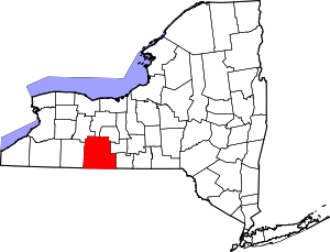 | |
| Towns | ||
| Villages | ||
| CDPs |
| |
| Hamlets | ||
| Footnotes | ‡This populated place also has portions in an adjacent county or counties | |