Savona, New York
| Savona, New York | |
|---|---|
| Village | |
 Savona, New York Location within the state of New York | |
| Coordinates: 42°17′7″N 77°13′8″W / 42.28528°N 77.21889°WCoordinates: 42°17′7″N 77°13′8″W / 42.28528°N 77.21889°W | |
| Country | United States |
| State | New York |
| County | Steuben |
| Area | |
| • Total | 1.0 sq mi (2.7 km2) |
| • Land | 1.0 sq mi (2.7 km2) |
| • Water | 0.0 sq mi (0.0 km2) |
| Elevation | 1,053 ft (321 m) |
| Population (2000) | |
| • Total | 822 |
| • Density | 786.5/sq mi (303.7/km2) |
| Time zone | Eastern (EST) (UTC-5) |
| • Summer (DST) | EDT (UTC-4) |
| ZIP code | 14879 |
| Area code(s) | 607 |
| FIPS code | 36-65354 |
| GNIS feature ID | 0964516 |
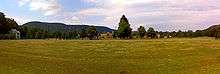
Savona is a village in Steuben County, New York, United States. The population was 822 at the 2000 census. The village is named after Savona in Italy.
The Village of Savona is located in the eastern part of the Town of Bath. The village is located at the intersection of Routes 226, 415, and Interstate 86.
History
The name "Mud Creek" was associated with the village in the 19th Century. The village was incorporated in 1883.
Unwanted attention was brought to the village in 1993 by the slaying of a young boy, Derrick Robie, aged four, by [then] thirteen-year-old Eric Smith.
Geography
Savona is located at 42°17′7″N 77°13′8″W / 42.28528°N 77.21889°W (42.285283, -77.218814).[1]
According to the United States Census Bureau, the village has a total area of 1.0 square mile (2.6 km2), all of it land.
The village is next to the Cohocton River at the confluence of Mud Creek and is at the intersection of New York State Route 226 and New York State Route 415.
Sanford Lake is a small lake north of the village.[2]
Demographics
| Historical population | |||
|---|---|---|---|
| Census | Pop. | %± | |
| 1880 | 447 | — | |
| 1890 | 569 | 27.3% | |
| 1900 | 611 | 7.4% | |
| 1910 | 587 | −3.9% | |
| 1920 | 516 | −12.1% | |
| 1930 | 545 | 5.6% | |
| 1940 | 653 | 19.8% | |
| 1950 | 869 | 33.1% | |
| 1960 | 904 | 4.0% | |
| 1970 | 933 | 3.2% | |
| 1980 | 932 | −0.1% | |
| 1990 | 974 | 4.5% | |
| 2000 | 822 | −15.6% | |
| 2010 | 827 | 0.6% | |
| Est. 2015 | 808 | [3] | −2.3% |
As of the census[5] of 2000, there were 822 people, 317 households, and 230 families residing in the village. The population density was 786.5 people per square mile (302.3/km²). There were 339 housing units at an average density of 324.4 per square mile (124.7/km²). The racial makeup of the village was 98.54% White, 0.49% Native American, 0.12% Asian, 0.24% from other races, and 0.61% from two or more races. Hispanic or Latino of any race were 0.61% of the population.
There were 317 households out of which 36.0% had children under the age of 18 living with them, 47.9% were married couples living together, 16.1% had a female householder with no husband present, and 27.4% were non-families. 23.0% of all households were made up of individuals and 10.1% had someone living alone who was 65 years of age or older. The average household size was 2.59 and the average family size was 2.97.
In the village the population was spread out with 27.5% under the age of 18, 8.9% from 18 to 24, 28.1% from 25 to 44, 25.3% from 45 to 64, and 10.2% who were 65 years of age or older. The median age was 35 years. For every 100 females there were 93.4 males. For every 100 females age 18 and over, there were 89.2 males.
The median income for a household in the village was $33,182, and the median income for a family was $39,018. Males had a median income of $30,893 versus $20,156 for females. The per capita income for the village was $15,194. About 10.5% of families and 13.9% of the population were below the poverty line, including 22.0% of those under age 18 and 2.1% of those age 65 or over.
References
- ↑ "US Gazetteer files: 2010, 2000, and 1990". United States Census Bureau. 2011-02-12. Retrieved 2011-04-23.
- ↑ "Official Map of Steuben County, NY," 2012
- ↑ "Annual Estimates of the Resident Population for Incorporated Places: April 1, 2010 to July 1, 2015". Retrieved July 2, 2016.
- ↑ "Census of Population and Housing". Census.gov. Retrieved June 4, 2015.
- ↑ "American FactFinder". United States Census Bureau. Retrieved 2008-01-31.
External links
Municipalities and communities of Steuben County, New York, United States | ||
|---|---|---|
| Cities | 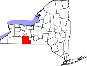 | |
| Towns | ||
| Villages | ||
| CDPs |
| |
| Hamlets | ||
| Footnotes | ‡This populated place also has portions in an adjacent county or counties | |