Brandenburg, Kentucky
| Brandenburg, Kentucky | |
|---|---|
| City | |
|
Meade County courthouse in Brandenburg | |
 Location of Brandenburg, Kentucky | |
| Coordinates: 37°59′34″N 86°10′29″W / 37.99278°N 86.17472°WCoordinates: 37°59′34″N 86°10′29″W / 37.99278°N 86.17472°W | |
| Country | United States |
| State | Kentucky |
| County | Meade |
| Area | |
| • Total | 4.0 sq mi (10.3 km2) |
| • Land | 4.0 sq mi (10.2 km2) |
| • Water | 0.0 sq mi (0.0 km2) |
| Elevation | 568 ft (173 m) |
| Population (2000) | |
| • Total | 2,049 |
| • Density | 518.0/sq mi (200.0/km2) |
| Time zone | Eastern (EST) (UTC-5) |
| • Summer (DST) | EDT (UTC-4) |
| ZIP code | 40108 |
| Area code(s) | 270 & 364 |
| FIPS code | 21-09226 |
| GNIS feature ID | 0487822 |
| Website | www.brandenburgky.org |

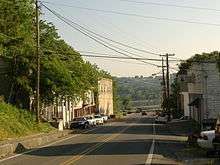
Brandenburg is a home rule-class city[1] on the Ohio River in Meade County, Kentucky, in the United States. This city is forty-six miles southwest of Louisville. It is the seat of its county.[2] The population was 2,049 at the 2000 census. The city was not named after Brandenburg, Germany, but for a local barkeep and land owner.
History
Brandenburg was built on a 3,000-acre (12 km2) tract of land called Falling Springs, purchased in 1804 by Solomon Brandenburg. He opened a tavern around which the community grew. In 1825, the community became the seat of Meade County, but it wasn't formally incorporated by the state assembly until March 28, 1872.[3]
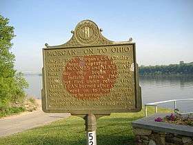
During the Civil War, Confederate General John Hunt Morgan crossed at Brandenburg to start his raid into Indiana in July, 1863. During the Battle of Brandenburg Crossing, two men on the Indiana side of the river were killed by cannon fire from Brandenburg. A Union gunship was deployed to block the crossing, but it ran out of ammunition and Morgan and his men were able to pass into Indiana.
Brandenburg was devastated by an F5 tornado during the Super Outbreak of April 3, 1974. Thirty-one residents lost their lives in this city. There was no early warning from tornado sirens or NOAA Weather Wire Service about the storm. About an hour after the storm, the same supercell spawned an F4 tornado that formed in the southwest part of Louisville in Jefferson County near Kosmosdale. Three people lost their lives in this storm, but it also left two hundred and seven injuries.
Geography
Brandenburg is located at 37°59′34″N 86°10′29″W / 37.99278°N 86.17472°W (37.992664, -86.174657).[4] According to the United States Census Bureau, the city has a total area of 4.0 square miles (10 km2), all land.
Demographics
| Historical population | |||
|---|---|---|---|
| Census | Pop. | %± | |
| 1830 | 331 | — | |
| 1860 | 618 | — | |
| 1870 | 427 | −30.9% | |
| 1880 | 587 | 37.5% | |
| 1890 | 495 | −15.7% | |
| 1900 | 218 | −56.0% | |
| 1910 | 482 | 121.1% | |
| 1920 | 503 | 4.4% | |
| 1930 | 484 | −3.8% | |
| 1940 | 561 | 15.9% | |
| 1950 | 755 | 34.6% | |
| 1960 | 1,542 | 104.2% | |
| 1970 | 1,637 | 6.2% | |
| 1980 | 1,831 | 11.9% | |
| 1990 | 1,857 | 1.4% | |
| 2000 | 2,049 | 10.3% | |
| 2010 | 2,643 | 29.0% | |
| Est. 2015 | 2,852 | [5] | 7.9% |
As of the census[7] of 2000, there were 2,049 people, 844 households, and 535 families residing in the city. The population density was 518.0 people per square mile (199.8/km²). There were 917 housing units at an average density of 231.8 per square mile (89.4/km²). The racial makeup of the city was 94.05% White, 3.90% African American, 0.54% Native American, 0.24% from other races, and 1.27% from two or more races. Hispanic or Latino of any race were 0.83% of the population.
There were 844 households out of which 33.6% had children under the age of 18 living with them, 43.4% were married couples living together, 15.6% had a female householder with no husband present, and 36.5% were non-families. 32.1% of all households were made up of individuals and 12.9% had someone living alone who was 65 years of age or older. The average household size was 2.32 and the average family size was 2.92.
The age distribution was 26.2% under the age of 18, 9.6% from 18 to 24, 28.6% from 25 to 44, 20.0% from 45 to 64, and 15.6% who were 65 years of age or older. The median age was 36 years. For every 100 females there were 87.6 males. For every 100 females age 18 and over, there were 82.7 males.
The median income for a household in the city was $36,351, and the median income for a family was $42,950. Males had a median income of $30,565 versus $21,143 for females. The per capita income for the city was $17,863. About 14.4% of families and 15.4% of the population were below the poverty line, including 19.3% of those under age 18 and 19.1% of those age 65 or over.
Attractions
Attractions near Brandenburg include:
- [Southern Grace Bed and Breakfast] www.southerngracebb.com
- Otter Creek Park, with campgrounds and river frontage
Notable person
- Rick Stansbury, college basketball coach
See also
References
- ↑ "Summary and Reference Guide to House Bill 331 City Classification Reform" (PDF). Kentucky League of Cities. Retrieved December 30, 2014.
- ↑ "Find a County". National Association of Counties. Archived from the original on 2011-05-31. Retrieved 2011-06-07.
- ↑ Commonwealth of Kentucky. Office of the Secretary of State. Land Office. "Brandenburg, Kentucky". Accessed 22 Jul 2013.
- ↑ "US Gazetteer files: 2010, 2000, and 1990". United States Census Bureau. 2011-02-12. Retrieved 2011-04-23.
- ↑ "Annual Estimates of the Resident Population for Incorporated Places: April 1, 2010 to July 1, 2015". Retrieved July 2, 2016.
- ↑ "Census of Population and Housing". Census.gov. Archived from the original on May 11, 2015. Retrieved June 4, 2015.
- ↑ "American FactFinder". United States Census Bureau. Archived from the original on 2013-09-11. Retrieved 2008-01-31.
External links
| Wikimedia Commons has media related to Brandenburg, Kentucky. |
-
 Brandenburg, Kentucky travel guide from Wikivoyage
 - City of Brandenburg
Municipalities and communities of Meade County, Kentucky, United States | ||
|---|---|---|
| Cities | 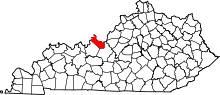 | |
| CDPs |
| |
| Unincorporated communities | ||
| Footnotes | ‡This populated place also has portions in an adjacent county or counties | |