Falmouth, Kentucky
| Falmouth, Kentucky | |
|---|---|
| City | |
|
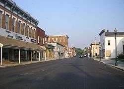
Downtown Falmouth | |
 Location of Falmouth, Kentucky | |
| Coordinates: 38°40′26″N 84°20′3″W / 38.67389°N 84.33417°WCoordinates: 38°40′26″N 84°20′3″W / 38.67389°N 84.33417°W | |
| Country | United States |
| State | Kentucky |
| County | Pendleton |
| Area | |
| • Total | 1.3 sq mi (3.3 km2) |
| • Land | 1.3 sq mi (3.3 km2) |
| • Water | 0.0 sq mi (0.0 km2) |
| Elevation | 551 ft (168 m) |
| Population (2010) | |
| • Total | 2,169 |
| • Density | 1,598.9/sq mi (617.4/km2) |
| Time zone | Eastern (EST) (UTC-5) |
| • Summer (DST) | EDT (UTC-4) |
| ZIP code | 41040 |
| Area code(s) | 859 |
| FIPS code | 21-26434 |
| GNIS feature ID | 0491967 |
| Website |
cityoffalmouth |
Falmouth is a home rule-class city[1] in, and the county seat of, Pendleton County, Kentucky,[2] in the United States. The population was 2,169 according to the 2010 census. It lies at the confluence of the South and Main forks of the Licking River and is home to Kincaid Regional Theatre.
Geography
Falmouth is located at 38°40′26″N 84°20′3″W / 38.67389°N 84.33417°W (38.673860, -84.334213).[3]
According to the United States Census Bureau, the city has a total area of 1.3 square miles (3.4 km2), all land.
History
Possibly settled as early as 1780, Falmouth was laid out by John Waller (1758-1823) and formally established by the state assembly in 1793. Waller named the new settlement after his native Falmouth, Virginia.[4] It was incorporated as a city in 1856.[5]
The town is perhaps best remembered for natural disasters that have devastated the town over the last half of the 20th Century. In 1964, the Licking River reached 47 feet (19 feet above flood stage) and left much of the town under water. On April 23, 1968 a tornado leveled many homes in the town. On March 2, 1997, a major flood on the Licking River again left the town crippled. The river reached 52 feet (24 feet above flood stage) and left 80% of the town under several feet of water. Many homes and business were damaged and five residents were killed.
Elzey Hughes House is listed on the National Register of Historic Places.
Arts and culture
Kincaid Regional Theatre, also referred to as KRT, has called Falmouth home since 1983. Since the theatre's founding, KRT has achieved musical theatre excellence by employing local actors from the Cincinnati metropolitan area and beyond. With the help of many supporters, KRT continues to enhance the arts in the community with a summer children's theatre workshop and through involvement with local schools. Summer and Christmas musicals are staged in an indoor, air-conditioned auditorium at the Falmouth School Center, previously known as the Pendleton County Middle School and Falmouth High School. Some of the most recent productions put on by KRT have been: All Shook Up, Joseph and the Technicolor Coat of Many Colors, Fiddler on the Roof, A Country Christmas Carol, A Christmas Story, Willy Wonka Jr., and Honk Jr.
Falmouth also hosts one of Kentucky's largest fall events, the Kentucky Wool Festival. The Wool Festival is an annual event that takes place just outside Kincaid Lake State Park during the first full weekend of October. The festival promotes sheep, wool products, and the local community, providing activities and entertainment for all age groups. Heritage demonstrations also highlight Pendleton County and Kentucky history.
Demographics
| Historical population | |||
|---|---|---|---|
| Census | Pop. | %± | |
| 1800 | 40 | — | |
| 1810 | 121 | 202.5% | |
| 1830 | 207 | — | |
| 1860 | 315 | — | |
| 1870 | 614 | 94.9% | |
| 1880 | 967 | 57.5% | |
| 1890 | 1,146 | 18.5% | |
| 1900 | 1,134 | −1.0% | |
| 1910 | 1,180 | 4.1% | |
| 1920 | 1,330 | 12.7% | |
| 1930 | 1,876 | 41.1% | |
| 1940 | 2,099 | 11.9% | |
| 1950 | 2,186 | 4.1% | |
| 1960 | 2,568 | 17.5% | |
| 1970 | 2,593 | 1.0% | |
| 1980 | 2,482 | −4.3% | |
| 1990 | 2,378 | −4.2% | |
| 2000 | 2,058 | −13.5% | |
| 2010 | 2,169 | 5.4% | |
| Est. 2015 | 2,127 | [6] | −1.9% |
As of the census[8] of 2000, there were 2,058 people, 849 households, and 521 families residing in the city. The population density was 1,598.9 people per square mile (616.0/km²). There were 988 housing units at an average density of 767.6 per square mile (295.7/km²). The racial makeup of the city was 96.21% White, 1.90% African American, 0.63% Native American, 0.10% Asian, 0.63% from other races, and 0.53% from two or more races. Hispanic or Latino of any race were 1.36% of the population.
There were 849 households out of which 31.1% had children under the age of 18 living with them, 41.7% were married couples living together, 15.3% had a female householder with no husband present, and 38.6% were non-families. 34.7% of all households were made up of individuals and 18.5% had someone living alone who was 65 years of age or older. The average household size was 2.34 and the average family size was 3.03.
In the city the population was spread out with 25.9% under the age of 18, 9.4% from 18 to 24, 28.1% from 25 to 44, 19.3% from 45 to 64, and 17.2% who were 65 years of age or older. The median age was 37 years. For every 100 females there were 89.9 males. For every 100 females age 18 and over, there were 82.4 males.
The median income for a household in the city was $25,114, and the median income for a family was $36,250. Males had a median income of $31,012 versus $20,781 for females. The per capita income for the city was $15,634. About 16.5% of families and 19.0% of the population were below the poverty line, including 22.9% of those under age 18 and 16.3% of those age 65 or over.
Notable people
- Dr. Phillip Allen Sharp, who earned the Nobel Prize for work that fundamentally changed scientists' understanding of the structure of genes, is a native of Falmouth.
- Rev. Father J. M. Lelen, PhD was pastor of St. Francis Xavier Roman Catholic Church in Falmouth for many years in the first half of the 20th century.
- Beth Broderick, actress on Sabrina, the Teenage Witch
Climate
The climate in this area is characterized by hot, humid summers and generally mild to cool winters. According to the Köppen Climate Classification system, Falmouth has a humid subtropical climate, abbreviated "Cfa" on climate maps.[9]
References
- ↑ "Summary and Reference Guide to House Bill 331 City Classification Reform" (PDF). Kentucky League of Cities. Retrieved December 30, 2014.
- ↑ "Find a County". National Association of Counties. Retrieved 2011-06-07.
- ↑ "US Gazetteer files: 2010, 2000, and 1990". United States Census Bureau. 2011-02-12. Retrieved 2011-04-23.
- ↑ Rennick, Robert M. (1987). Kentucky Place Names. University Press of Kentucky. p. 98. Retrieved 2013-04-28.
- ↑ Commonwealth of Kentucky. Office of the Secretary of State. Land Office. "Falmouth, Kentucky". Accessed 26== Jul 2013.
- ↑ "Annual Estimates of the Resident Population for Incorporated Places: April 1, 2010 to July 1, 2015". Retrieved July 2, 2016.
- ↑ "Census of Population and Housing". Census.gov. Retrieved June 4, 2015.
- ↑ "American FactFinder". United States Census Bureau. Retrieved 2008-01-31.
- ↑ Climate Summary for Falmouth, Kentucky
External links
- Official website
- Pendleton County Views – Falmouth historical images and documents, from Northern Kentucky Views
- Flood of '97 – special coverage from the Cincinnati Enquirer
Municipalities and communities of Pendleton County, Kentucky, United States | ||
|---|---|---|
| Cities |  | |
| Unincorporated communities | ||
| Footnotes | ‡This populated place also has portions in an adjacent county or counties | |