Bristol County, Massachusetts
| Bristol County, Massachusetts | ||
|---|---|---|
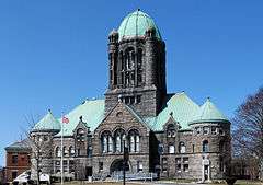 Bristol Superior Court House | ||
| ||
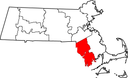 Location in the U.S. state of Massachusetts | ||
 Massachusetts's location in the U.S. | ||
| Founded |
June 2, 1685 (from Plymouth Colony) | |
| Named for | Bristol, Rhode Island | |
| Seat | Taunton | |
| Largest city | New Bedford | |
| Area | ||
| • Total | 691 sq mi (1,790 km2) | |
| • Land | 553 sq mi (1,432 km2) | |
| • Water | 138 sq mi (357 km2), 20% | |
| Population | ||
| • (2010) | 548,285 | |
| • Density | 991/sq mi (383/km²) | |
| Congressional districts | 4th, 8th, 9th | |
| Time zone | Eastern: UTC-5/-4 | |
| Website |
www | |

Bristol County is a county in the Commonwealth of Massachusetts. As of the 2010 census, the population was 548,285.[1] The county seat is Taunton.[2] Some governmental functions are performed by the Commonwealth of Massachusetts, others by the county, and others by local towns and cities. See Administrative divisions of Massachusetts. The property deed records are kept in Taunton, Attleboro, Fall River, and New Bedford.
Bristol County is part of the Providence-Warwick, RI-MA Metropolitan Statistical Area, which is also included in the Boston-Worcester-Providence, MA-RI-NH-CT Combined Statistical Area. The county is adjacent to the state of Rhode Island.
The adjacent counties are Plymouth County, Norfolk County, Bristol County, Rhode Island, Newport County, Rhode Island, Providence County, Rhode Island, and Dukes County.
History
Bristol County was created by the Plymouth Colony on June 2, 1685,[3] and named after its "shire town" (county seat), Bristol.[4] The Plymouth Colony merged into the Massachusetts Bay Colony in 1691.
The towns of Bristol, Barrington, and Warren were awarded to Rhode Island in 1746 as part of a long-running boundary dispute (see History of Massachusetts), forming Bristol County, Rhode Island. At the same time, Cumberland, Rhode Island was carved out of Attleborough, Massachusetts and annexed to Providence County, Rhode Island; Tiverton and Little Compton were transferred to Newport County, Rhode Island. East Freetown was officially purchased by Freetown, Massachusetts, from Tiverton in 1747, and so remained on the Massachusetts side.
After the departure of Bristol, Taunton was made the shire town of the county. A second county courthouse was constructed in 1828 in the growing town of New Bedford (designed a "half-shire town"). In 1862, part of Seekonk (now East Providence, Rhode Island) and the entirety of East Pawtucket were transferred to Providence County, Rhode Island. At the same time, land ceded from Rhode Island was added to Fall River and Westport. The growing Fall River became the site of the third county courthouse in 1877.[4]
Geography
According to the U.S. Census Bureau, the county has a total area of 691 square miles (1,790 km2), of which 553 square miles (1,430 km2) is land and 138 square miles (360 km2) (20%) is water.[5] The highest point in Bristol County is Sunrise Hill (Watery Hill) at 390 feet (120 m) above sea level located in World War I Memorial Park in North Attleborough. It is also to note that Bristol, Plymouth and Taunton are all places in South West England. Their Massachusetts cousins were named after the originals as South West England was the focal point for sailing and discovery at the time of America's discovery. John Cabot set sail from Bristol and sailed down the Severn on which lies Newport over in Wales. He then stumbled across mainland U.S.A.
Adjacent counties
- Norfolk County, Massachusetts — north
- Plymouth County, Massachusetts — east
- Newport County, Rhode Island — southwest
- Bristol County, Rhode Island — west
- Providence County, Rhode Island — northwest
To the south, Dukes County, Massachusetts is opposite Buzzards Bay from Bristol County.
Bristol County in Massachusetts and Bristol County in Rhode Island are two of twenty-two counties or parishes in the United States with the same name to border each other across state lines. The others are Union Parish, Louisiana and Union County, Arkansas, Big Horn County, Montana and Big Horn County, Wyoming, Sabine County, Texas and Sabine Parish, Louisiana, Kent County, Maryland and Kent County, Delaware, Escambia County, Alabama and Escambia County, Florida, Pike County, Illinois and Pike County, Missouri, Teton County, Idaho and Teton County, Wyoming, Park County, Montana and Park County, Wyoming, San Juan County, New Mexico and San Juan County, Utah, and Vermilion County, Illinois and Vermillion County, Indiana. respectively. (Note, despite the different spellings, the source of the name is the same for Vermilion County, Illinois and Vermillion County, Indiana—the Vermillion River which flows through both counties.)
National protected area
Demographics
| Historical population | |||
|---|---|---|---|
| Census | Pop. | %± | |
| 1790 | 31,696 | — | |
| 1800 | 33,880 | 6.9% | |
| 1810 | 37,168 | 9.7% | |
| 1820 | 40,908 | 10.1% | |
| 1830 | 49,592 | 21.2% | |
| 1840 | 60,164 | 21.3% | |
| 1850 | 76,192 | 26.6% | |
| 1860 | 93,794 | 23.1% | |
| 1870 | 102,886 | 9.7% | |
| 1880 | 139,040 | 35.1% | |
| 1890 | 186,465 | 34.1% | |
| 1900 | 252,029 | 35.2% | |
| 1910 | 318,573 | 26.4% | |
| 1920 | 359,005 | 12.7% | |
| 1930 | 364,590 | 1.6% | |
| 1940 | 364,637 | 0.0% | |
| 1950 | 381,569 | 4.6% | |
| 1960 | 398,488 | 4.4% | |
| 1970 | 444,301 | 11.5% | |
| 1980 | 474,641 | 6.8% | |
| 1990 | 506,325 | 6.7% | |
| 2000 | 534,678 | 5.6% | |
| 2010 | 548,285 | 2.5% | |
| Est. 2015 | 556,772 | [6] | 1.5% |
| U.S. Decennial Census[7] 1790-1960[8] 1900-1990[9] 1990-2000[10] 2010-2013[1] | |||
2000 census
As of the census[11] of 2000, there were 534,678 people, 205,411 households, and 140,706 families residing in the county. The population density was 962 people per square mile (371/km²). There were 216,918 housing units at an average density of 390 per square mile (151/km²). The racial makeup of the county was 90.98% White, 2.03% Black or African American, 0.24% Native American, 1.26% Asian, 0.03% Pacific Islander, 3.12% from other races, and 2.34% from two or more races. 3.60% of the population was Hispanic or Latino of any race. 29.7% were of Portuguese, 13.0% Irish, 8.9% French, 8.2% English, 6.8% Italian and 6.4% French Canadian ancestry according to Census 2000. 79.1% spoke English, 13.9% Portuguese, 2.9% Spanish and 1.6% French as their first language. The United States Census Bureau reported Bristol County as being one of two counties in the United States with a plurality of people of Portuguese ancestry[12] (the other being the contiguous Bristol County Rhode Island).
There were 205,411 households out of which 33.00% had children under the age of 18 living with them, 51.60% were married couples living together, 13.00% had a female householder with no husband present, and 31.50% were non-families. 26.50% of all households were made up of individuals and 11.00% had someone living alone who was 65 years of age or older. The average household size was 2.54 and the average family size was 3.08.
In the county the population was spread out with 24.60% under the age of 18, 8.50% from 18 to 24, 30.50% from 25 to 44, 22.20% from 45 to 64, and 14.10% who were 65 years of age or older. The median age was 37 years. For every 100 females there were 92.40 males. For every 100 females age 18 and over, there were 88.50 males.
The median income for a household in the county was $43,496, and the median income for a family was $53,733. Males had a median income of $39,361 versus $27,516 for females. The per capita income for the county was $20,978. About 7.80% of families and 10.00% of the population were below the poverty line, including 13.00% of those under age 18 and 12.00% of that age 65 or over.
2010 census
As of the 2010 United States Census, there were 548,285 people, 213,010 households, and 141,338 families residing in the county.[13] The population density was 991.3 inhabitants per square mile (382.7/km2). There were 230,535 housing units at an average density of 416.8 per square mile (160.9/km2).[14] The racial makeup of the county was 88.4% white, 3.3% black or African American, 1.9% Asian, 0.4% American Indian, 3.4% from other races, and 2.6% from two or more races. Those of Hispanic or Latino origin made up 6.0% of the population.[13] In terms of ancestry, 30.1% were Portuguese, 19.2% were Irish, 12.5% were English, 9.3% were Italian, 5.7% were French Canadian, 5.0% were German, and 2.5% were American.[15]
Of the 213,010 households, 32.6% had children under the age of 18 living with them, 47.5% were married couples living together, 14.0% had a female householder with no husband present, 33.6% were non-families, and 27.4% of all households were made up of individuals. The average household size was 2.50 and the average family size was 3.06. The median age was 39.8 years.[13]
The median income for a household in the county was $54,955 and the median income for a family was $70,161. Males had a median income of $51,785 versus $39,714 for females. The per capita income for the county was $27,736. About 8.8% of families and 11.3% of the population were below the poverty line, including 15.7% of those under age 18 and 10.4% of those age 65 or over.[16]
Demographic breakdown by town
Income
The ranking of unincorporated communities that are included on the list are reflective if the census designated locations and villages were included as cities or towns. Data is from the 2007-2011 American Community Survey 5-Year Estimates.[17][18][19]
| Rank | Town | Per capita income |
Median household income |
Median family income |
Population | Number of households | |
|---|---|---|---|---|---|---|---|
| 1 | Mansfield | Town | $39,792 | $98,182 | $112,788 | 23,094 | 8,161 |
| 2 | Easton | Town | $39,751 | $89,714 | $111,045 | 23,061 | 7,852 |
| 3 | Rehoboth | Town | $38,415 | $87,563 | $97,711 | 11,470 | 4,093 |
| 4 | Westport | Town | $35,337 | $73,736 | $83,289 | 15,396 | 5,867 |
| Massachusetts | State | $35,051 | $65,981 | $83,371 | 6,512,227 | 2,522,409 | |
| 5 | Raynham | Town | $34,904 | $82,855 | $96,190 | 13,208 | 4,739 |
| 6 | North Attleborough | Town | $34,374 | $80,757 | $94,469 | 28,593 | 10,426 |
| 7 | Dighton | Town | $34,258 | $85,284 | $94,044 | 7,003 | 2,386 |
| 8 | Swansea | Town | $33,910 | $71,716 | $79,486 | 15,886 | 6,173 |
| North Westport | CDP | $33,858 | $67,614 | $82,827 | 4,188 | 1,700 | |
| 9 | Seekonk | Town | $33,136 | $78,032 | $89,833 | 13,700 | 4,752 |
| 10 | Freetown | Town | $32,437 | $82,208 | $93,773 | 8,828 | 3,150 |
| 11 | Dartmouth | Town | $32,138 | $73,007 | $86,650 | 33,759 | 12,119 |
| Raynham Center | CDP | $32,034 | $84,028 | $91,154 | 4,619 | 1,563 | |
| Mansfield Center | CDP | $31,762 | $71,685 | $98,902 | 7,946 | 3,022 | |
| 12 | Somerset | Town | $31,718 | $69,449 | $80,795 | 18,172 | 6,983 |
| 13 | Norton | Town | $30,772 | $75,538 | $91,636 | 18,970 | 6,297 |
| North Seekonk | CDP | $30,705 | $65,804 | $81,111 | 2,552 | 941 | |
| 14 | Attleboro | City | $30,398 | $65,298 | $76,563 | 43,459 | 16,393 |
| Smith Mills | CDP | $30,207 | $67,907 | $79,123 | 5,030 | 1,965 | |
| 15 | Acushnet | Town | $30,084 | $64,695 | $81,643 | 10,299 | 3,818 |
| Bliss Corner | CDP | $29,569 | $52,285 | $63,554 | 6,063 | 2,534 | |
| Bristol County | County | $28,682 | $55,813 | $71,416 | 547,305 | 210,536 | |
| 16 | Fairhaven | Town | $28,658 | $60,179 | $77,089 | 15,915 | 6,444 |
| 17 | Berkley | Town | $28,206 | $81,094 | $83,228 | 6,336 | 1,970 |
| United States | Country | $27,915 | $52,762 | $64,293 | 306,603,772 | 114,761,359 | |
| 18 | Taunton | City | $26,309 | $53,401 | $67,447 | 55,930 | 21,799 |
| Acushnet Center | CDP | $26,295 | $51,782 | $64,750 | 2,737 | 1,159 | |
| Ocean Grove | CDP | $25,058 | $60,267 | $72,594 | 3,098 | 1,230 | |
| 19 | New Bedford | City | $21,558 | $37,493 | $46,881 | 95,006 | 38,869 |
| 20 | Fall River | City | $21,118 | $34,789 | $44,635 | 89,220 | 38,245 |
| Norton Center | CDP | $16,578 | $83,465 | $84,781 | 2,977 | 446 | |
Politics and government
| Year | Democrat | Republican |
|---|---|---|
| 2012 | 59.2% 142,962 | 38.8% 93,752 |
| 2008 | 60.4% 146,861 | 37.2% 90,531 |
| 2004 | 63.5% 147,854 | 35.4% 82,524 |
| 2000 | 64.5% 136,325 | 29.7% 62,848 |
- Paul B. Kitchen—County Commissioner
- John R. Mitchell—County Commissioner
- John T. Saunders—County Commissioner
- Thomas M. Quinn, III—District Attorney
- Thomas M. Hodgson—Sheriff
- Christopher T. Saunders—County Treasurer
- Barry Amaral—Register of Deeds, Northern District
- Bernard McDonald—Register of Deeds, Fall River District
- J. Mark Treadup—Register of Deeds, Southern District
- Marc Santos—Clerk of Courts
| Voter Registration and Party Enrollment as of October 13, 2010[21] | |||||
|---|---|---|---|---|---|
| Party | Number of Voters | Percentage | |||
| Democratic | 129,735 | 37.32% | |||
| Republican | 35,469 | 10.20% | |||
| Unenrolled | 180,285 | 51.86% | |||
| Minor Parties | 2,121 | 0.61% | |||
| Total | 347,610 | 100% | |||
The Bristol County Sheriff's Office maintains its administrative headquarters and operates several jail facilities in the Dartmouth Complex in North Dartmouth in Dartmouth. Jail facilities in the Dartmouth Complex include the Bristol County House Of Correction and Jail, the Bristol County Sheriff's Office Women’s Center, and the C. Carlos Carreiro Immigration Detention Center. The office also operates the Ash Street Jail and Regional Lock-Up and the Juvenile Secure Alternative Lock Up Program (JALP) in New Bedford.[22]
The Bristol County House Of Correction and Jail has room for 1,100 prisoners. It houses men convicted of crimes who have been sentenced to 2 1/2 years or less. It also houses high-security male pre-trial prisoners, high-security female prisoners, and pre-trial female prisoners.[22]
The women's center, a medium security jail, can house up to 106 women. The self-contained women's center had opened as a minimum security pre-release center for male prisoners in 1990 which could house up to 106 prisoners. When it was a pre-release facility it only housed an average of 60 prisoners because the county sheriff imposed strict conditions upon the pre-release program. In 1999 the sheriff received a federal grant to convert the pre-release center into a women's center, and he moved the pre-release program to modular units at the main jail.[22]
The Carreiro jail houses detained individuals who are scheduled for deportation and individuals who are engaging in proceedings with the Immigration and Customs Enforcement (ICE). The Ash Street jail houses over 200 pre-trial prisoners and a few sentenced inmate workers for the system. JALP houses up to 12 pre-arraingment juvenile prisoners.[22]
Transportation
Transportation authorities providing public bus service include the Greater Attleboro Taunton Regional Transit Authority; and the Southeastern Regional Transit Authority serving the Fall River and New Bedford areas.
Airports include the Mansfield Municipal Airport, Myricks Airport, New Bedford Municipal Airport and Taunton Municipal Airport; of these, the New Bedford airport is a commercial airport, with flights serving the Cape Cod, Nantucket and Martha's Vineyard area.
The Providence/Stoughton Line of the MBTA commuter rail has stops in Mansfield, Attleboro, and South Attleboro. The line provides connections to Providence and Boston (at Back Bay Station and South Station), as well as intermediate stops. An extension has been completed that connects to T.F. Green Airport.
Communities
Cities
- Attleboro
- Fall River
- New Bedford
- Taunton (county seat)
Towns
Villages
Villages are census division, but have no separate corporate existence from the towns they are in.
- Acushnet Center
- Assonet
- Bliss Corner
- Bowensville
- Britannia
- East Freetown
- East Taunton
- Fall River Station
- Five Corners
- Flint Village
- Four Corners
- Globe Village
- Gushee Pond
- Highlands
- Hixville
- Hornbine
- Hortonville
- Kingmans Corner
- Mansfield Center
- Myricks
- North Attleborough Center
- North Dighton
- North Easton
- North Raynham
- North Rehoboth
- North Seekonk
- North Taunton
- North Westport
- Norton Center
- Oakland
- Ocean Grove
- Padanaram
- Pecks Corner
- Perrys Corner
- Perryville
- Pleasantfield
- Pleasant Street
- Pottersville
- Prattville
- Ramblewood
- Raynham Center
- Rehoboth
- Sassaquin
- Smith Mills
- South Attleboro
- South Rehoboth
- South Easton
- Squawbetty
- Steep Brook
- Titicut
- Tracy Corner
- Wade's Corner
- Weir Village
- Westville
- Whittenton
- Whittenton Junction
Ghost town
See also
- Registry of Deeds (Massachusetts)
- Bristol Community College
- Horseneck Beach State Reservation
- Freetown-Fall River State Forest
- National Register of Historic Places listings in Bristol County, Massachusetts
- Southern New England School of Law
- Taunton River
- Taunton River Watershed
- University of Massachusetts Dartmouth
- Wheaton College
References
- 1 2 "State & County QuickFacts". United States Census Bureau. Retrieved August 26, 2013.
- ↑ "Find a County". National Association of Counties. Archived from the original on 2011-05-31. Retrieved 2011-06-07.
- ↑ Bristol County, Massachusetts, USA
- 1 2 History of Bristol County, Massachusetts with Biographical Sketches of many of its Pioneers and Prominent Men, Part 1 edited by Duane Hamilton Hurd. J.W. Lewis and Co., 1883. . p. 1.
- ↑ "2010 Census Gazetteer Files". United States Census Bureau. August 22, 2012. Retrieved September 15, 2014.
- ↑ "County Totals Dataset: Population, Population Change and Estimated Components of Population Change: April 1, 2010 to July 1, 2015". Retrieved July 2, 2016.
- ↑ "U.S. Decennial Census". United States Census Bureau. Archived from the original on May 11, 2015. Retrieved September 15, 2014.
- ↑ "Historical Census Browser". University of Virginia Library. Retrieved September 15, 2014.
- ↑ "Population of Counties by Decennial Census: 1900 to 1990". United States Census Bureau. Retrieved September 15, 2014.
- ↑ "Census 2000 PHC-T-4. Ranking Tables for Counties: 1990 and 2000" (PDF). United States Census Bureau. Retrieved September 15, 2014.
- ↑ "American FactFinder". United States Census Bureau. Archived from the original on 2013-09-11. Retrieved 2008-01-31.
- ↑ Census 2000 Brief - Ancestry
- 1 2 3 "DP-1 Profile of General Population and Housing Characteristics: 2010 Demographic Profile Data". United States Census Bureau. Retrieved 2016-01-12.
- ↑ "Population, Housing Units, Area, and Density: 2010 - County". United States Census Bureau. Retrieved 2016-01-12.
- ↑ "DP02 SELECTED SOCIAL CHARACTERISTICS IN THE UNITED STATES – 2006-2010 American Community Survey 5-Year Estimates". United States Census Bureau. Retrieved 2016-01-12.
- ↑ "DP03 SELECTED ECONOMIC CHARACTERISTICS – 2006-2010 American Community Survey 5-Year Estimates". United States Census Bureau. Retrieved 2016-01-12.
- ↑ "SELECTED ECONOMIC CHARACTERISTICS 2007-2011 American Community Survey 5-Year Estimates". U.S. Census Bureau. Retrieved 2013-01-26.
- ↑ "ACS DEMOGRAPHIC AND HOUSING ESTIMATES 2007-2011 American Community Survey 5-Year Estimates". U.S. Census Bureau. Retrieved 2013-01-26.
- ↑ "HOUSEHOLDS AND FAMILIES 2007-2011 American Community Survey 5-Year Estimates". U.S. Census Bureau. Retrieved 2013-01-26.
- ↑ "Dave Leip's Atlas of U.S. Presidential Elections". Retrieved 2011-06-11.
- ↑ "Registration and Party Enrollment Statistics as of October 13, 2010" (PDF). Massachusetts Elections Division. Retrieved 2010-01-31.
- 1 2 3 4 "Facilities." Bristol County Sheriff's Office. Retrieved on January 30, 2012. "400 Faunce Corner Road, Dartmouth, MA 0274" and "Bristol County House Of Correction and Jail 400 Faunce Corner Road North Dartmouth, MA 02747" and "Bristol County Sheriff's Office Women’s Center 400 Faunce Corner Road North Dartmouth, MA 02747" and "C. Carlos Carreiro Immigration Detention Center: 400 Faunce Corner Road North Dartmouth, MA 02747" and "Juvenile Secure Alternative Lock Up Program 323 Mill Street New Bedford, MA 02740 " and "Ash Street Jail and Regional Lock-Up 226 Ash Street New Bedford, MA 02740 "
Further reading
- The Bristol County Directory, Boston, Mass.: Dean Dudley & Co., 1878
- History of Bristol County, Massachusetts with Biographical Sketches of many of its Pioneers and Prominent Men, Part 1 edited by Duane Hamilton Hurd. J.W. Lewis and Co., 1883.
- The Bristol County Directory, Boston, Mass.: Briggs & Co., 1885, OCLC 8750817
- A history of Bristol County, Massachusetts, Volume 1 by Frank Walcott Hutt. Lewis Historical Pub. Co., Inc., 1924.
External links
- countyofbristol
.net  Geographic data related to Bristol County, Massachusetts at OpenStreetMap
 |
Providence County, Rhode Island | Norfolk County | | |
| Bristol County, Rhode Island | |
Plymouth County | ||
| ||||
| | ||||
| Newport County, Rhode Island | Buzzards Bay |
Municipalities and communities of Bristol County, Massachusetts, United States | ||
|---|---|---|
| Cities | | |
| Towns | ||
| CDPs | ||
| Other villages | ||
| Ghost town | ||
Boston (capital) | |
| Topics |
|
| Society | |
| Regions | |
| Counties | |
| Cities |
|
Coordinates: 41°45′N 71°05′W / 41.75°N 71.09°W