Buffalo, Buffalo County, Wisconsin
| Buffalo, Wisconsin | |
|---|---|
| Town | |
 Town of Buffalo | |
| Coordinates: 44°4′17″N 91°36′49″W / 44.07139°N 91.61361°WCoordinates: 44°4′17″N 91°36′49″W / 44.07139°N 91.61361°W | |
| Country | United States |
| State | Wisconsin |
| County | Buffalo |
| Area | |
| • Total | 34.2 sq mi (88.5 km2) |
| • Land | 27.8 sq mi (72.1 km2) |
| • Water | 6.3 sq mi (16.4 km2) |
| Elevation[1] | 1,115 ft (340 m) |
| Population (2010) | |
| • Total | 705 |
| • Density | 25/sq mi (9.8/km2) |
| Time zone | Central (CST) (UTC-6) |
| • Summer (DST) | CDT (UTC-5) |
| FIPS code | 55-11025[2] |
| GNIS feature ID | 1582885[1] |
Buffalo is a town in Buffalo County in the U.S. state of Wisconsin. The population was 705 at the 2010 census.[3] The unincorporated communities of Bluff Siding, East Winona, and Marshland are located in the town.
Geography
Buffalo occupies the southern end of Buffalo County and is bordered by the Mississippi River, which forms the state line with Minnesota, to the southwest and by the Trempealeau River, which forms the border with Trempealeau County, to the east. The town is connected by the North Channel Bridge and Main Channel Bridge across the Mississippi River to the city of Winona, Minnesota. The city of Fountain City, Wisconsin, borders the northwest edge of the town. The city of Buffalo City is unrelated to the town and is located 16 miles (26 km) to the northwest.
According to the United States Census Bureau, the town has a total area of 34.2 square miles (88.5 km2), of which 27.8 square miles (72.1 km2) is land and 6.3 square miles (16.4 km2), or 18.53%, is water.[3]
Demographics
As of the census[2] of 2000, there were 667 people, 260 households, and 192 families residing in the town. The population density was 22.3 people per square mile (8.6/km²). There were 277 housing units at an average density of 9.3 per square mile (3.6/km²). The racial makeup of the town was 99.40% White, 0.30% Native American, and 0.30% from two or more races. Hispanic or Latino of any race were 0.75% of the population.
There were 260 households out of which 28.1% had children under the age of 18 living with them, 66.9% were married couples living together, 4.2% had a female householder with no husband present, and 25.8% were non-families. 21.9% of all households were made up of individuals and 8.5% had someone living alone who was 65 years of age or older. The average household size was 2.57 and the average family size was 2.98.
In the town the population was spread out with 23.5% under the age of 18, 6.0% from 18 to 24, 27.1% from 25 to 44, 29.4% from 45 to 64, and 13.9% who were 65 years of age or older. The median age was 41 years. For every 100 females there were 109.7 males. For every 100 females age 18 and over, there were 112.5 males.
The median income for a household in the town was $44,750, and the median income for a family was $48,333. Males had a median income of $27,344 versus $22,321 for females. The per capita income for the town was $21,431. About 2.1% of families and 2.2% of the population were below the poverty line, including none of those under age 18 and 6.5% of those age 65 or over.
References
- 1 2 "US Board on Geographic Names". United States Geological Survey. 2007-10-25. Retrieved 2008-01-31.
- 1 2 "American FactFinder". United States Census Bureau. Archived from the original on 2013-09-11. Retrieved 2008-01-31.
- 1 2 "Geographic Identifiers: 2010 Demographic Profile Data (G001): Buffalo town, Buffalo County, Wisconsin". U.S. Census Bureau, American Factfinder. Retrieved May 14, 2014.
External links
- Town of Buffalo page at Buffalo County website
Municipalities and communities of Buffalo County, Wisconsin, United States | ||
|---|---|---|
| Cities | 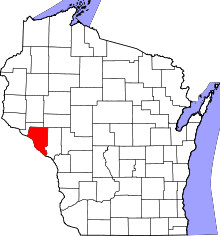 | |
| Villages | ||
| Towns | ||
| CDP | ||
| Unincorporated communities | ||
| Ghost towns | ||