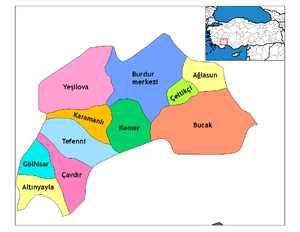
Burdur
| Burdur | |
|---|---|
| Municipality | |
|
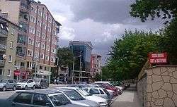
Namık Kemal Avenue in central Burdur | |
 Burdur | |
| Coordinates: 37°43′00″N 30°17′00″E / 37.71667°N 30.28333°ECoordinates: 37°43′00″N 30°17′00″E / 37.71667°N 30.28333°E | |
| Country | Turkey |
| Province | Burdur |
| Government | |
| • Mayor | Ali Orkun Ercengiz (CHP) |
| Area[1] | |
| • District | 1,450.98 km2 (560.23 sq mi) |
| Population (2012)[2] | |
| • Urban | 72,377 |
| • District | 96,816 |
| • District density | 67/km2 (170/sq mi) |
| Website |
www |
Burdur is a city southwestern Turkey and the seat of the Burdur Province of Turkey. It is located at 37°43′13″N 30°17′27″E / 37.7202778°N 30.2908333°E, on the shore of Lake Burdur. Its estimated 2010 population is 78,389.[3]
History
Ancient history
Whilst there is evidence of habitation in the province dating back to 6500 BC, the earliest sign of habitation in the city itself dates to Early Bronze Age. Artifacts from this period have been found in the site of today's railway station. In antiquity, the area was part of the region of Pisidia. It has been proposed that the city of Burdur has changed location a number of times; the ancient city of Limnombria ("Lake City") was closer to Lake Burdur than the modern city. It is known that in the Byzantine era, the city existed with the name Polydorion (Greek: Πολυδώριον), from which the current name is derived.[4] No remains of Polydorion survive to this day.[5]
Turkish settlement and the Hamidids
The history of the urban development of Burdur is generally held to begin with the Turkish settlement after the Seljuq victory at the Battle of Manzikert in 1071. In the late 11th century, the Kınalı tribe of the Oghuz Turks captured the Burdur area and settled there. Turks became the majority of the population of the area after 1211, establishing a number of villages in addition to expanding the town.[6] The first Turkish settlement was in an area known as Hamam Bendi that had a lower elevation than today's city but was farther to the lake than the ancient town of Limnombria. These residents used the site of today's Grand Mosque of Burdur as an open marketplace, known as Alanpazarı. Realising the high incidence of malaria in the area they had settled, these residents then moved uphill, away from the lake.[4] These first residents had not submitted to any state, but Kilij Arslan II, the Seljuq Sultan of Rum, captured the area in 1177 and imposed his sovereignty over the local tribes.[7] The town remained under the undisputed sovereignty of the Sultanate of Rum between 1206 and 1260, when it was captured by the Mongol Empire. Developing commerce in the port of Antalya increased the significance of Burdur as a centre of commerce. Tragacanth obtained from the mountains of Psidia, wine from Kütahya, wax, wood and tar from many parts of Anatolia passed through Burdur, in exchange of which Egyptian spices, cotton and sugar was traded.[6]
In 1300, the Hamidids under Dündar Bey captured Burdur. Dündar Bey had the Grand Mosque of Burdur built around a hilly area in 1300, and the town subsequently developed around the mosque. The Hamidids administered Burdur as a district under the town of Eğirdir. The Ilkhanate then captured Burdur in 1324 under the governor of Anatolia, Timurtash. Dündar Bey's son, İshak Çelebi, recaptured Burdur in 1328.[4] Traveller Ibn Battuta visited the town in 1330. In the account of his visit, he described Burdur as a town blessed with natural beauty and a number of orchards and farms, centred around the Burdur Castle near the Grand Mosque. No trace of the castle remains today except for the names of some of the streets, indicating that with the lack of a strategic requirement for a castle, it was gradually destroyed. The account also indicates the presence of a guild of ahis controlling commerce and production. By comparing the description of Burdur with the presentation of other cities such as Eğirdir, Isparta and Denizli, it can be deduced that Burdur was a relatively minor urban centre with limited commerce.[6] It was, nevertheless, still a stop on the trade route between Konya, the cities of the Black Sea and the ports of the Aegean Sea.[8]
Burdur was captured by the Ottoman Empire in 1391, when Bayezid I conquered the Hamidids. It was initially a district centre and a small town under the Sanjak of Hamid. As of 1478, Burdur had four quarters, three being Muslim and one being Christian. The largest of these was the Cami ("Mosque") quarter of the Muslims.[4]
Climate
Burdur has a continental Mediterranean climate with cold, snowy winters and very hot, long and dry summers.
| Climate data for Burdur | |||||||||||||
|---|---|---|---|---|---|---|---|---|---|---|---|---|---|
| Month | Jan | Feb | Mar | Apr | May | Jun | Jul | Aug | Sep | Oct | Nov | Dec | Year |
| Record high °C (°F) | 16.6 (61.9) |
19.4 (66.9) |
27.8 (82) |
30.7 (87.3) |
33.5 (92.3) |
38.1 (100.6) |
40.7 (105.3) |
41.0 (105.8) |
37.0 (98.6) |
32.4 (90.3) |
25.6 (78.1) |
20.5 (68.9) |
41 (105.8) |
| Average high °C (°F) | 6.9 (44.4) |
8.5 (47.3) |
12.8 (55) |
17.6 (63.7) |
23.1 (73.6) |
28.2 (82.8) |
32.0 (89.6) |
32.2 (90) |
27.8 (82) |
21.4 (70.5) |
14.0 (57.2) |
8.2 (46.8) |
19.39 (66.91) |
| Average low °C (°F) | −1.1 (30) |
−0.7 (30.7) |
1.9 (35.4) |
5.9 (42.6) |
9.9 (49.8) |
13.9 (57) |
17.0 (62.6) |
16.8 (62.2) |
12.7 (54.9) |
8.2 (46.8) |
3.5 (38.3) |
0.6 (33.1) |
7.38 (45.28) |
| Record low °C (°F) | −14.0 (6.8) |
−13.0 (8.6) |
−11.6 (11.1) |
−7.0 (19.4) |
−0.4 (31.3) |
5.2 (41.4) |
9.7 (49.5) |
10.2 (50.4) |
4.4 (39.9) |
−2.0 (28.4) |
−9.9 (14.2) |
−11.0 (12.2) |
−14 (6.8) |
| Average precipitation mm (inches) | 51.1 (2.012) |
39.3 (1.547) |
45.0 (1.772) |
50.4 (1.984) |
39.6 (1.559) |
26.0 (1.024) |
17.6 (0.693) |
9.2 (0.362) |
17.8 (0.701) |
35.8 (1.409) |
42.2 (1.661) |
59.1 (2.327) |
433.1 (17.051) |
| Average rainy days | 11.0 | 9.7 | 10.0 | 10.7 | 9.4 | 5.6 | 3.5 | 2.5 | 3.6 | 6.3 | 7.9 | 10.9 | 91.1 |
| Mean monthly sunshine hours | 114.7 | 137.2 | 182.9 | 204 | 275.9 | 330 | 359.6 | 337.9 | 273 | 217 | 156 | 93 | 2,681.2 |
| Source: Devlet Meteoroloji İşleri Genel Müdürlüğü [9] | |||||||||||||
Education
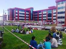
Mehmet Akif Ersoy University is located in Burdur.
Notable residents
- Burdurlu Dervish Mehmed Pasha Ottoman Grand Vizier 1818-1820
- Burdurlu Ahmet Şükrü Pasha Ottoman Military Doctor, with major improvements in medical awards.
References
- ↑ "Area of regions (including lakes), km²". Regional Statistics Database. Turkish Statistical Institute. 2002. Retrieved 2013-03-05.
- ↑ "Population of province/district centers and towns/villages by districts - 2012". Address Based Population Registration System (ABPRS) Database. Turkish Statistical Institute. Retrieved 2013-02-27.
- ↑ Statistical Institute.
- 1 2 3 4 "Burdur". İslam Ansiklopedisi. 6. Türk Diyanet Vakfı. 1992. pp. 426–429.
- ↑ "Burdur". Büyük Larousse. 4. Milliyet. p. 2012.
- 1 2 3 Çetin, Bayram (2007), Burdur kent coğrafyası (PhD thesis) (in Turkish), Atatürk University, pp. 68–74
- ↑ Atasoy, Sertan (2013), Burdur'un ilçelerindeki Türk dönemi eserleri (Master's thesis) (in Turkish), Pamukkale University, pp. 3–6
- ↑ Eskikurt, Adnan (2014). "Ortaçağ Anadolu Ticaret Yolları". Muğla Sıtkı Koçman University Journal of the Institute of Social Sciences (33): 15–40.
- ↑ "Archived copy". Archived from the original on 2011-04-30. Retrieved 2011-04-13.
External links
| Wikimedia Commons has media related to Burdur (city). |
- Governor's official website
- Site with a few pictures
- Very many pictures of the Archaeological Museum
- Burdur News