Carnegie, Victoria
| Carnegie Melbourne, Victoria | |||||||||||||
|---|---|---|---|---|---|---|---|---|---|---|---|---|---|
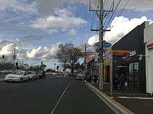
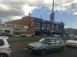 Princes Entertainment Centre in Carnegie on Princes Highway | |||||||||||||
 Carnegie | |||||||||||||
| Coordinates | 37°53′17″S 145°03′43″E / 37.888°S 145.062°ECoordinates: 37°53′17″S 145°03′43″E / 37.888°S 145.062°E | ||||||||||||
| Population | 16,299 (2011 census)[1] | ||||||||||||
| • Density | 4,290/km2 (11,110/sq mi) | ||||||||||||
| Postcode(s) | 3163 | ||||||||||||
| Area | 3.8 km2 (1.5 sq mi) | ||||||||||||
| Location | 12 km (7 mi) from Melbourne | ||||||||||||
| LGA(s) | City of Glen Eira | ||||||||||||
| State electorate(s) | Oakleigh | ||||||||||||
| Federal Division(s) | Higgins | ||||||||||||
| |||||||||||||
Carnegie is a suburb in Melbourne, Victoria, Australia, 12 km south-east from Melbourne's central business district.[2] Its local government area is the City of Glen Eira. At the 2011 Census, Carnegie had a population of 16,299. Its postcode is 3163.
The suburb's main shopping precinct is on Koornang Road, between Dandenong Road and Neerim Road.
Originally called Rosstown, after William Murray Ross, a prominent property developer and entrepreneur, a name change came about due to Ross' failed speculative developments and in 1909 it was renamed Carnegie[3] in an ultimately unsuccessful attempt to secure funds for a library from the philanthropist Andrew Carnegie.
History
Toponomy
Originally called Rosstown, after developer William Murray Ross one of the early pioneers of the area. The original name lives on in the name of the local hotel, and Rosstown Road. Leila Road is named after Mr Ross's wife, and Grange Road is named after Ross's estate, The Grange, which has since been subdivided and is now suburban housing estates.
In 1909 Carnegie was chosen as a new name in an ultimately unsuccessful attempt to secure funds for a library from the philanthropist Andrew Carnegie.
Establishment
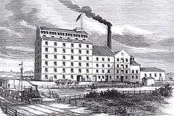
In 1875 Ross began circulating a broadsheet proposal which detailed the Rosstown project, a large scale sugar beet processing mill, a railway line to serve it, and a residential estate, named after him on the edge of the metropolis between Melbourne and the town of Oakleigh. Although he began building the mill, it never began production, and the Rosstown Railway he constructed was never used.
However the estate sold well and gradually Rosstown had grown to a reasonable size aided by the opening of the railway to Melbourne in 1879.
Carnegie Post Office opened on 1 September 1911.[4] Carnegie was originally part of the City of Caulfield and by the 1920s it had a substantial commercial area.
The Carnegie theatre was a popular cinema in the 1930s.
Transport
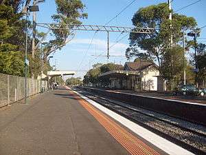
The northern part of Carnegie and the Koornang Road shopping strip is served by Carnegie Station on the Cranbourne/Pakenham line. Carnegie is served by bus routes 623, 624, 626, 900 and NightRider 980. The terminus of the Carnegie tram route is just south of the shopping centre and serves the southern part of Carnegie. The Public Transport Users Association has instigated calls for its extension to the nearby Carnegie railway station which services the shopping centre, as a major mode interchange .
Buses
- SmartBus service
- NightRider services
Trains
There are two train services that pass through Carnegie railway station. Both to Flinders Street station and to Pakenham or Cranbourne stations.
| Destination | Destination | Via. |
|---|---|---|
| Flinders Street | Pakenham | Direct or the City Loop, Dandenong Station |
| Flinders Street | Cranbourne | Direct or the City Loop, Dandenong Station |
Demographics
Carnegie has a diverse cultural cross-section, with many permanent settlers from across the globe, and transient international students studying at the nearby Monash University (Caulfield campus).
Commercial Centres
Koornang Road
On Koornang Road alone there are restaurants and grocers offering Malaysian, Korean, Chinese, Thai, Japanese, Italian, Greek and Russian foods, as well as the Rosstown Hotel.
Princes Highway
Dandenong road is increasingly becoming a focus of Carnegie's development. Originally the Rosstown Hotel was the focus of this part of the commercial strip, however today there are numerous showrooms and homemaker stores including Officeworks.
Schools
The main primary school is Carnegie Primary School (No. 2897) (established in 1888 as Rosstown State School).[5]
References
- ↑ Australian Bureau of Statistics (31 October 2012). "Carnegie (State Suburb)". 2011 Census QuickStats. Retrieved 11 February 2013.
- ↑ http://www.postcodes-australia.com/areas/vic/mulgrave/carnegie
- ↑ CHANGES IN NAMES OF STATIONS - The Argus 24 April 1909
- ↑ Premier Postal History, Post Office List, retrieved 11 April 2008
- ↑ Isabel Couper & Deirdre Lynch, Carnegie Primary School no.2897 The first 100 years 1888-1988 ISBN 0 7316 28314