Central Savannah River Area
| Central Savannah River Area | |
|---|---|
| CSRA | |
|
| |
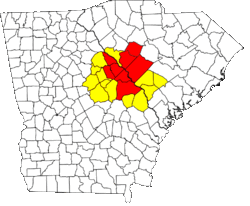
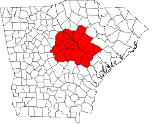 Map outlining the Central Savannah River Area | |
| Country |
|
| State |
|
| Largest city | Augusta |
| Area | |
| • Total | 9,605 sq mi (24,880 km2) |
| • Land | 9,400 sq mi (24,000 km2) |
| • Water | 205 sq mi (530 km2) 2.1% |
| Population (2014) | |
| • Total | 768,402 |
| • Density | 79/sq mi (31/km2) |
| Time zone | EST (UTC-5) |
| • Summer (DST) | EDT (UTC-4) |
| Area code(s) | 478, 706, 762, 803, 864, |
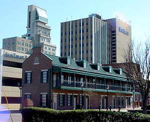

The Central Savannah River Area (CSRA) is a trading and marketing region in the U.S. states of Georgia and South Carolina, spanning thirteen counties in Georgia and eight in South Carolina.[1][1] The term was coined in 1950 by C.C. McCollum, the winner of a $250 contest held by The Augusta Chronicle to generate the best name for the area.[1] Today the initialism is so commonly used that the full name is not known to all residents.[1] The region is located on and named after the Savannah River, which forms the border between the two states. The largest cities within the CSRA are Augusta, Georgia and Aiken, South Carolina. (The CSRA does not include the city of Savannah, Georgia or any portion of the Savannah metropolitan area.)
The total population of the CSRA is 861,631 in 2010. According to the U.S. Census Bureau, the seven-county Augusta-Richmond County Metropolitan Statistical Area (at the center of the CSRA) had an estimated population of 580,270 in 2013,[2] making it the second most populous in the state of Georgia.
Counties
In Georgia
| County | Total Area | Population (2015) |
|---|---|---|
| Richmond County | 329 sq mi (850 km2) | 202,003 |
| Columbia County | 308 sq mi (800 km2) | 139,257 |
| Burke County | 835 sq mi (2,160 km2) | 23,316 |
| McDuffie County | 266 sq mi (690 km2) | 21,875 |
| Washington County | 684 sq mi (1,770 km2) | 20,635 |
| Jefferson County | 530 sq mi (1,400 km2) | 16,930 |
| Screven County | 656 sq mi (1,700 km2) | 14,593 |
| Wilkes County | 474 sq mi (1,230 km2) | 10,593 |
| Jenkins County | 352 sq mi (910 km2) | 9,125 |
| Lincoln County | 257 sq mi (670 km2) | 7,996 |
| Warren County | 287 sq mi (740 km2) | 5,834 |
| Glascock County | 144 sq mi (370 km2) | 3,082 |
| Total: | 5,812 sq mi (15,050 km2) | 498,106 |
In South Carolina
| County | Total Area | Population (2014) |
|---|---|---|
| Aiken County | 1,081 sq mi (2,800 km2) | 164,753 |
| Edgefield County | 507 sq mi (1,310 km2) | 26,985 |
| Barnwell County | 557 sq mi (1,440 km2) | 22,621 |
| Saluda County | 462 sq mi (1,200 km2) | 20,026 |
| Bamberg County | 396 sq mi (1,030 km2) | 15,987 |
| McCormick County | 394 sq mi (1,020 km2) | 10,233 |
| Allendale County | 412 sq mi (1,070 km2) | 10,419 |
| Orangeburg County | 1,128 sq mi (2,920 km2) | 89,208 |
| Total: | 4,937 sq mi (12,790 km2) | 363,525 |
Communities
Places with more than 100,000 inhabitants
- Augusta-Richmond County (balance), Georgia (Principal city) Pop: 197,872
Places with 10,000 to 40,000 inhabitants
- Martinez, Georgia Pop: 35,795
- Aiken, South Carolina Pop: 29,884
- Evans, Georgia Pop: 29,011
- North Augusta, South Carolina Pop: 21,873
- Grovetown, Georgia Pop: 12,210
Places with 5,000 to 10,000 inhabitants
- Thomson, Georgia Pop: 6,718
- Belvedere, South Carolina Pop: 5,792
- Waynesboro, Georgia Pop: 5,816
Places with 1,000 to 5,000 inhabitants
|
|
Places with less than 1,000 inhabitants
|
|
References
External links
- CSRA Regional Commission (only encompassing the 13 Georgia counties)
- CSRA Economic Opportunity Authority, Inc. (only encompassing the 13 Georgia counties)
- Savannah River Site: CSRA Regional Science and Engineering Fair Regional science fair competition for science projects winning first-place at their respective schools (Grades 4-12)
- Columbia County outpaces state population gains
Coordinates: 33°30′54″N 82°12′58″W / 33.51500°N 82.21611°W