Barnwell County, South Carolina
| Barnwell County, South Carolina | |
|---|---|
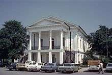 Barnwell County Courthouse | |
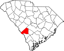 Location in the U.S. state of South Carolina | |
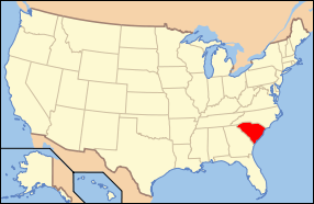 South Carolina's location in the U.S. | |
| Founded | 1800 |
| Seat | Barnwell |
| Largest city | Barnwell |
| Area | |
| • Total | 557 sq mi (1,443 km2) |
| • Land | 548 sq mi (1,419 km2) |
| • Water | 8.9 sq mi (23 km2), 1.6% |
| Population | |
| • (2010) | 22,621 |
| • Density | 41/sq mi (16/km²) |
| Congressional district | 2nd |
| Time zone | Eastern: UTC-5/-4 |
| Website |
www |
Barnwell County is a county located in the U.S. state of South Carolina. As of the 2010 census, its population was 22,621.[1] Its county seat is Barnwell.[2]
History
The Barnwell District was created in 1797 (effective in 1800) from the southwestern portion of the Orangeburg District, along the Savannah River.[3] It was named after John Barnwell, a local figure in the Revolutionary War.[4]
In 1868, under the South Carolina Constitution revised during Reconstruction, South Carolina districts became counties. The government was made more democratic, with county officials to be elected by male citizens at least 21 years old,[5] rather than by the state legislature as done previously.
In 1871 the legislature took the northwestern portion of the county to form part of the new Aiken County, the only county organized during the Reconstruction era. In 1874 the border with Aiken County was adjusted slightly. This county and Barnwell, with populations of blacks and whites that were nearly equal, had extensive violence in the months before the 1874 and 1876 elections, as groups of paramilitary Red Shirts rode to disrupt black Republican meetings and intimidate voters to suppress black voting. More than 100 black men were killed in Aiken County during the violence, especially at Ellenton, South Carolina.
In 1895 white Democrats in the state legislature passed a new constitution, disfranchising most blacks for more than 60 years by raising barriers to voter registration.
In 1897 the eastern third of the county was taken to form the new Bamberg County. In 1919 most of the southern half of the county was taken to form most of the new Allendale County, thus reducing Barnwell county to its present size.
Geography
According to the U.S. Census Bureau, the county has a total area of 557 square miles (1,440 km2), of which 548 square miles (1,420 km2) is land and 8.9 square miles (23 km2) (1.6%) is water.[6]
Adjacent counties
- Aiken County - north
- Bamberg County - east
- Orangeburg County - east
- Allendale County - southeast
- Burke County, Georgia - southwest
Demographics
| Historical population | |||
|---|---|---|---|
| Census | Pop. | %± | |
| 1800 | 7,376 | — | |
| 1810 | 12,280 | 66.5% | |
| 1820 | 14,750 | 20.1% | |
| 1830 | 19,236 | 30.4% | |
| 1840 | 21,471 | 11.6% | |
| 1850 | 26,608 | 23.9% | |
| 1860 | 30,743 | 15.5% | |
| 1870 | 35,724 | 16.2% | |
| 1880 | 39,857 | 11.6% | |
| 1890 | 44,613 | 11.9% | |
| 1900 | 35,504 | −20.4% | |
| 1910 | 34,209 | −3.6% | |
| 1920 | 23,081 | −32.5% | |
| 1930 | 21,221 | −8.1% | |
| 1940 | 20,138 | −5.1% | |
| 1950 | 17,266 | −14.3% | |
| 1960 | 17,659 | 2.3% | |
| 1970 | 17,176 | −2.7% | |
| 1980 | 19,868 | 15.7% | |
| 1990 | 20,293 | 2.1% | |
| 2000 | 23,478 | 15.7% | |
| 2010 | 22,621 | −3.7% | |
| Est. 2015 | 21,725 | [7] | −4.0% |
| U.S. Decennial Census[8] 1790-1960[9] 1900-1990[10] 1990-2000[11] 2010-2013[1] | |||
2000 census
As of the census[12] of 2000, there were 23,478 people, 9,021 households, and 6,431 families residing in the county. The population density was 43 people per square mile (17/km²). There were 10,191 housing units at an average density of 19 per square mile (7/km²). The racial makeup of the county was 55.18% White, 42.55% Black or African American, 0.35% Native American, 0.39% Asian, 0.03% Pacific Islander, 0.78% from other races, and 0.72% from two or more races. 1.39% of the population were Hispanic or Latino of any race.
There were 9,021 households out of which 34.80% had children under the age of 18 living with them, 47.40% were married couples living together, 19.30% had a female householder with no husband present, and 28.70% were non-families. 25.60% of all households were made up of individuals and 10.20% had someone living alone who was 65 years of age or older. The average household size was 2.57 and the average family size was 3.08.
In the county, the population was spread out with 28.10% under the age of 18, 8.70% from 18 to 24, 27.90% from 25 to 44, 22.60% from 45 to 64, and 12.60% who were 65 years of age or older. The median age was 36 years. For every 100 females there were 92.70 males. For every 100 females age 18 and over, there were 86.50 males.
The median income for a household in the county was $28,591, and the median income for a family was $35,866. Males had a median income of $31,161 versus $21,904 for females. The per capita income for the county was $15,870. About 17.90% of families and 20.90% of the population were below the poverty line, including 27.30% of those under age 18 and 24.40% of those age 65 or over.
2010 census
As of the 2010 United States Census, there were 22,621 people, 8,937 households, and 6,055 families residing in the county.[13] The population density was 41.2 inhabitants per square mile (15.9/km2). There were 10,484 housing units at an average density of 19.1 per square mile (7.4/km2).[14] The racial makeup of the county was 52.6% white, 44.3% black or African American, 0.6% Asian, 0.4% American Indian, 0.7% from other races, and 1.5% from two or more races. Those of Hispanic or Latino origin made up 1.8% of the population.[13] In terms of ancestry, 11.5% were American, 5.7% were German, and 5.4% were English.[15]
Of the 8,937 households, 34.0% had children under the age of 18 living with them, 41.8% were married couples living together, 20.8% had a female householder with no husband present, 32.2% were non-families, and 28.4% of all households were made up of individuals. The average household size was 2.50 and the average family size was 3.05. The median age was 38.8 years.[13]
The median income for a household in the county was $33,816 and the median income for a family was $41,764. Males had a median income of $35,957 versus $30,291 for females. The per capita income for the county was $17,592. About 20.8% of families and 25.4% of the population were below the poverty line, including 39.6% of those under age 18 and 11.5% of those age 65 or over.[16]
Communities
City
- Barnwell (county seat)
Towns
See also
References
- 1 2 "State & County QuickFacts". United States Census Bureau. Retrieved November 22, 2013.
- ↑ "Find a County". National Association of Counties. Archived from the original on 2012-07-12. Retrieved 2011-06-07.
- ↑ "South Carolina: Individual County Chronologies". South Carolina Atlas of Historical County Boundaries. The Newberry Library. 2009. Retrieved March 20, 2015.
- ↑ "History". Barnwell County Government. Retrieved March 20, 2015.
- ↑ The Governor: Powers, Practices, Roles and the South Carolina Experience, from the website of the USC South Carolina Governance Project. Retrieved February 5, 2010.
- ↑ "2010 Census Gazetteer Files". United States Census Bureau. August 22, 2012. Retrieved March 16, 2015.
- ↑ "County Totals Dataset: Population, Population Change and Estimated Components of Population Change: April 1, 2010 to July 1, 2015". Retrieved July 2, 2016.
- ↑ "U.S. Decennial Census". United States Census Bureau. Archived from the original on May 11, 2015. Retrieved March 16, 2015.
- ↑ "Historical Census Browser". University of Virginia Library. Retrieved March 16, 2015.
- ↑ Forstall, Richard L., ed. (March 27, 1995). "Population of Counties by Decennial Census: 1900 to 1990". United States Census Bureau. Retrieved March 16, 2015.
- ↑ "Census 2000 PHC-T-4. Ranking Tables for Counties: 1990 and 2000" (PDF). United States Census Bureau. April 2, 2001. Retrieved March 16, 2015.
- ↑ "American FactFinder". United States Census Bureau. Archived from the original on 2013-09-11. Retrieved 2011-05-14.
- 1 2 3 "DP-1 Profile of General Population and Housing Characteristics: 2010 Demographic Profile Data". United States Census Bureau. Retrieved 2016-03-09.
- ↑ "Population, Housing Units, Area, and Density: 2010 - County". United States Census Bureau. Retrieved 2016-03-09.
- ↑ "DP02 SELECTED SOCIAL CHARACTERISTICS IN THE UNITED STATES – 2006-2010 American Community Survey 5-Year Estimates". United States Census Bureau. Retrieved 2016-03-09.
- ↑ "DP03 SELECTED ECONOMIC CHARACTERISTICS – 2006-2010 American Community Survey 5-Year Estimates". United States Census Bureau. Retrieved 2016-03-09.
External links
- Barnwell County
- The Barnwell Web
 Geographic data related to Barnwell County, South Carolina at OpenStreetMap
 |
Aiken County | | ||
| |
Orangeburg County and Bamberg County | |||
| ||||
| | ||||
| Burke County, Georgia | Allendale County |
Municipalities and communities of Barnwell County, South Carolina, United States | ||
|---|---|---|
| City | | |
| Towns | ||
| Ghost town | ||
Coordinates: 33°16′N 81°26′W / 33.26°N 81.44°W