Chémery-les-Deux
| Chémery-les-Deux | ||
|---|---|---|
 | ||
| ||
 Chémery-les-Deux | ||
|
Location within Grand Est region  Chémery-les-Deux | ||
| Coordinates: 49°18′01″N 6°26′41″E / 49.3003°N 6.4447°ECoordinates: 49°18′01″N 6°26′41″E / 49.3003°N 6.4447°E | ||
| Country | France | |
| Region | Grand Est | |
| Department | Moselle | |
| Arrondissement | Forbach-Boulay-Moselle | |
| Canton | Bouzonville | |
| Intercommunality | Communauté de communes du Bouzonvillois | |
| Government | ||
| • Mayor (2008–2014) | Maurice Ochem | |
| Area1 | 10.03 km2 (3.87 sq mi) | |
| Population (1999)2 | 381 | |
| • Density | 38/km2 (98/sq mi) | |
| Time zone | CET (UTC+1) | |
| • Summer (DST) | CEST (UTC+2) | |
| INSEE/Postal code | 57136 / 57320 | |
| Elevation |
209–284 m (686–932 ft) (avg. 230 m or 750 ft) | |
|
1 French Land Register data, which excludes lakes, ponds, glaciers > 1 km² (0.386 sq mi or 247 acres) and river estuaries. 2 Population without double counting: residents of multiple communes (e.g., students and military personnel) only counted once. | ||
.svg.png)
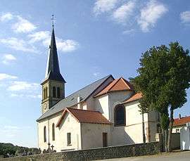
Chémery-les-Deux is a commune in the Moselle department in Grand Est in north-eastern France.
Localities of the commune: Hobling, Ingling, Klop.
See also
This article is issued from Wikipedia - version of the 11/17/2016. The text is available under the Creative Commons Attribution/Share Alike but additional terms may apply for the media files.