Saint-Louis, Moselle
For the commune of the Bitche canton, see Saint-Louis-lès-Bitche.
| Saint-Louis | ||
|---|---|---|
|
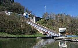
Saint-Louis-Arzviller inclined plane | ||
| ||
 Saint-Louis | ||
|
Location within Grand Est region  Saint-Louis | ||
| Coordinates: 48°43′01″N 7°11′20″E / 48.7169°N 7.1889°ECoordinates: 48°43′01″N 7°11′20″E / 48.7169°N 7.1889°E | ||
| Country | France | |
| Region | Grand Est | |
| Department | Moselle | |
| Arrondissement | Sarrebourg-Château-Salins | |
| Canton | Phalsbourg | |
| Intercommunality | Pays de Phalsbourg | |
| Government | ||
| • Mayor (2001–2008) | Gilbert Fixaris | |
| Area1 | 9.28 km2 (3.58 sq mi) | |
| Population (1999)2 | 707 | |
| • Density | 76/km2 (200/sq mi) | |
| Time zone | CET (UTC+1) | |
| • Summer (DST) | CEST (UTC+2) | |
| INSEE/Postal code | 57618 / 57820 | |
| Elevation | 215–393 m (705–1,289 ft) | |
|
1 French Land Register data, which excludes lakes, ponds, glaciers > 1 km² (0.386 sq mi or 247 acres) and river estuaries. 2 Population without double counting: residents of multiple communes (e.g., students and military personnel) only counted once. | ||

Saint-Louis (German: Sankt Ludwig bei Pfalzburg) is a commune in the Moselle department in Grand Est in north-eastern France.
See also
References
| Wikimedia Commons has media related to Saint-Louis, Moselle. |
This article is issued from Wikipedia - version of the 11/17/2016. The text is available under the Creative Commons Attribution/Share Alike but additional terms may apply for the media files.