Columbus, New York
| Columbus, New York | |
|---|---|
| Town | |
 Columbus Location within the state of New York | |
| Coordinates: 42°41′45″N 75°21′38″W / 42.69583°N 75.36056°W | |
| Country | United States |
| State | New York |
| County | Chenango |
| Government | |
| • Type | Town Council |
| • Town Supervisor | Thomas P. Grace (i) |
| • Town Council |
Members' List
|
| Area | |
| • Total | 37.5 sq mi (97.1 km2) |
| • Land | 37.4 sq mi (96.8 km2) |
| • Water | 0.1 sq mi (0.3 km2) |
| Elevation | 1,427 ft (435 m) |
| Population (2010) | |
| • Total | 975 |
| • Density | 26/sq mi (10.1/km2) |
| Time zone | Eastern (EST) (UTC-5) |
| • Summer (DST) | EDT (UTC-4) |
| ZIP code | 13411, 13485, 13460 |
| Area code(s) | 607 |
| FIPS code | 36-17486 |
| GNIS feature ID | 0978856 |
| Website |
www |
Columbus is a town in Chenango County, New York, United States. The population was 975 at the 2010 census.[1] Columbus is in the northeast corner of the county and is northeast of Norwich.
History
The area of Columbus was first settled around 1791. The town was formed in 1805 from the town of Brookfield (now in Madison County). Additional territory was obtained from the town of Norwich in 1807.
The Columbus Community Church was added to the National Register of Historic Places in 1986.[2]
Famous companies at Columbus include the makers of Chobani Yogurt and Golden Artist Colors.
Geography
According to the United States Census Bureau, the town has a total area of 37.5 square miles (97.1 km2), of which 37.4 square miles (96.8 km2) is land and 0.12 square miles (0.3 km2), or 0.33%, is water.[1]
The north town line is the border of Madison County, and the east town line is the border of Otsego County, marked by the Unadilla River, a south-flowing tributary of the Susquehanna River.
New York State Route 8 is a north-south highway by the east town line, and New York State Route 80 is an east-west highway.
The hamlet of Columbus is on NY-80 near the geographic center of the town. Columbus Quarter is a hamlet on the Unadilla River in the northeast part of the town.
Demographics
| Historical population | |||
|---|---|---|---|
| Census | Pop. | %± | |
| 1820 | 1,805 | — | |
| 1830 | 1,744 | −3.4% | |
| 1840 | 1,561 | −10.5% | |
| 1850 | 1,381 | −11.5% | |
| 1860 | 1,407 | 1.9% | |
| 1870 | 1,197 | −14.9% | |
| 1880 | 1,177 | −1.7% | |
| 1890 | 1,109 | −5.8% | |
| 1900 | 997 | −10.1% | |
| 1910 | 838 | −15.9% | |
| 1920 | 683 | −18.5% | |
| 1930 | 724 | 6.0% | |
| 1940 | 711 | −1.8% | |
| 1950 | 655 | −7.9% | |
| 1960 | 706 | 7.8% | |
| 1970 | 723 | 2.4% | |
| 1980 | 802 | 10.9% | |
| 1990 | 869 | 8.4% | |
| 2000 | 931 | 7.1% | |
| 2010 | 975 | 4.7% | |
| Est. 2014 | 958 | [3] | −1.7% |
As of the census[5] of 2000, there were 931 people, 342 households, and 243 families residing in the town. The population density was 24.9 people per square mile (9.6/km²). There were 428 housing units at an average density of 11.4 per square mile (4.4/km²). The racial makeup of the town was 97.64% White, 0.32% African American, 0.11% Native American, 0.11% Asian, 0.64% from other races, and 1.18% from two or more races. Hispanic or Latino of any race were 1.18% of the population.
There were 342 households out of which 33.6% had children under the age of 18 living with them, 59.9% were married couples living together, 7.3% had a female householder with no husband present, and 28.9% were non-families. 21.6% of all households were made up of individuals and 9.9% had someone living alone who was 65 years of age or older. The average household size was 2.72 and the average family size was 3.13.
In the town the population was spread out with 27.3% under the age of 18, 6.0% from 18 to 24, 29.2% from 25 to 44, 26.2% from 45 to 64, and 11.3% who were 65 years of age or older. The median age was 39 years. For every 100 females there were 98.5 males. For every 100 females age 18 and over, there were 98.5 males.
The median income for a household in the town was $27,452, and the median income for a family was $31,118. Males had a median income of $23,654 versus $20,952 for females. The per capita income for the town was $13,731. About 15.8% of families and 21.3% of the population were below the poverty line, including 25.9% of those under age 18 and 25.5% of those age 65 or over.
References
- 1 2 "Geographic Identifiers: 2010 Demographic Profile Data (G001): Columbus town, Chenango County, New York". U.S. Census Bureau, American Factfinder. Retrieved November 18, 2014.
- ↑ National Park Service (2009-03-13). "National Register Information System". National Register of Historic Places. National Park Service.
- ↑ "Annual Estimates of the Resident Population for Incorporated Places: April 1, 2010 to July 1, 2014". Retrieved June 4, 2015.
- ↑ "Census of Population and Housing". Census.gov. Archived from the original on May 11, 2015. Retrieved June 4, 2015.
- ↑ "American FactFinder". United States Census Bureau. Archived from the original on 2013-09-11. Retrieved 2008-01-31.
External links
Coordinates: 42°41′02″N 75°22′22″W / 42.68389°N 75.37278°W
Municipalities and communities of Chenango County, New York, United States | ||
|---|---|---|
| City | 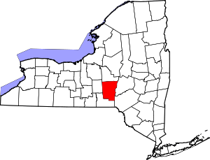 | |
| Towns | ||
| Villages | ||
| CDPs | ||
| Hamlets | ||
| Footnotes | ‡This populated place also has portions in an adjacent county or counties | |