Coxheath, Alabama
| Coxheath, Alabama | |
|---|---|
| Unincorporated community | |
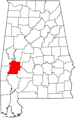
 Coxheath, Alabama  Coxheath, Alabama Location within the state of Alabama | |
| Coordinates: 32°5′16.51″N 87°54′37.01″W / 32.0879194°N 87.9102806°W | |
| Country | United States |
| State | Alabama |
| County | Marengo |
| Elevation | 151 ft (46 m) |
| Time zone | Central (CST) (UTC-6) |
| • Summer (DST) | CDT (UTC-5) |
| Area code(s) | 334 |
Coxheath is an unincorporated community in Marengo County, Alabama, United States.[1] Coxheath had a post office at one time, but it no longer exists.[2]
Geography
Coxheath is located at 32°05′17″N 87°54′37″W / 32.08792°N 87.91028°WCoordinates: 32°05′17″N 87°54′37″W / 32.08792°N 87.91028°W and has an elevation of 151 feet (46 m).[1]
References
This article is issued from Wikipedia - version of the 7/29/2016. The text is available under the Creative Commons Attribution/Share Alike but additional terms may apply for the media files.