Moores Valley, Alabama
| Moores Valley, Alabama | |
|---|---|
| Unincorporated community | |
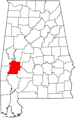
 Moores Valley, Alabama  Moores Valley, Alabama Location within the state of Alabama | |
| Coordinates: 32°3′39.53″N 87°37′48″W / 32.0609806°N 87.63000°W | |
| Country | United States |
| State | Alabama |
| County | Marengo |
| Elevation | 128 ft (39 m) |
| Time zone | Central (CST) (UTC-6) |
| • Summer (DST) | CDT (UTC-5) |
| Area code(s) | 334 |
Moores Valley is an unincorporated community in Marengo County, Alabama, United States.[1]
History
Moores Valley was founded when the Frisco Railroad was extended to that point.[2]
Geography
Moores Valley is located at 32°03′40″N 87°37′48″W / 32.06098°N 87.63000°WCoordinates: 32°03′40″N 87°37′48″W / 32.06098°N 87.63000°W and has an elevation of 128 feet (39 m).[1]
References
- 1 2 U.S. Geological Survey Geographic Names Information System: Moores Valley, Alabama
- ↑ Jones, Joel D. (12 October 2006). "Settlers establish Vineland, Surginer, Moore's Valley". The Democrat-Reporter. p. 2. Retrieved 23 April 2015.
This article is issued from Wikipedia - version of the 7/29/2016. The text is available under the Creative Commons Attribution/Share Alike but additional terms may apply for the media files.