Nashville, Indiana
| Nashville, Indiana | |
|---|---|
| Town | |
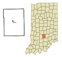 Location of Nashville in the state of Indiana | |
| Coordinates: 39°12′11″N 86°14′18″W / 39.20306°N 86.23833°WCoordinates: 39°12′11″N 86°14′18″W / 39.20306°N 86.23833°W | |
| Country | United States |
| State | Indiana |
| County | Brown |
| Township | Washington |
| Area[1] | |
| • Total | 1.02 sq mi (2.64 km2) |
| • Land | 1.01 sq mi (2.62 km2) |
| • Water | 0.01 sq mi (0.03 km2) |
| Elevation | 594 ft (181 m) |
| Population (2010)[2] | |
| • Total | 803 |
| • Estimate (2012[3]) | 1,084 |
| • Density | 795.0/sq mi (307.0/km2) |
| Time zone | Eastern (EST) (UTC-5) |
| • Summer (DST) | EDT (UTC-4) |
| ZIP code | 47448 |
| Area code(s) | 812 |
| FIPS code | 18-52038[4] |
| GNIS feature ID | 0439943[5] |
| Website | http://townofnashville.org/ |
Nashville is a town in Washington Township, Brown County, Indiana, United States. The population was 803 at the 2010 census. The town is the county seat of Brown County and is the county's only incorporated town.[6] The town is best known as the center of the Brown County Art Colony and as a tourist destination.
History
Settlement of land in and around Nashville began with the acquisition of land from native populations under the 1809 Treaty of Fort Wayne. This was expanded with more acquisitions under the 1818 Treaty of St. Mary's. Founded in 1836 by county agent Banner C. Brummett, it was first named Jacksonburg.[7] The population of the entire county was estimated to be 150 in 1830. The first Nashville courthouse was constructed in 1837 and a jail was added in the same year. By 1840, area population had grown to 2,364. The town was officially incorporated in 1872.[7] By the turn of the century, heavy logging in the area had caused significant deforestation which resulted in dramatic erosion problems.

In the early twentieth century, a number of artists settled in the area, most notably T. C. Steele, the American Impressionist painter. These artists were the basis for the Brown County Art Colony, which continues to this day as the Brown County Art Guild.[8]
The Brown County Courthouse Historic District and F.P. Taggart Store are listed on the National Register of Historic Places.[9]
Tourism
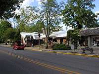
Today, Nashville boasts a tourist industry based upon the original works of resident artists and upon the area's natural beauty. Brown County State Park is nearby. Art, antique, and specialty shops, as well as galleries, restaurants, and entertainment venues, make up downtown Nashville, and many inns, rented cottages, and bed and breakfast establishments serve visitors.
Geography
Nashville is located at 39°12′11″N 86°14′18″W / 39.20306°N 86.23833°W (39.203025, -86.238236).[10]
According to the 2010 census, Nashville has a total area of 1.01 square miles (2.62 km2), all land.[1]
Nashville's rolling hills, ridges, and valleys are a story of the north fork of Salt Creek. The surrounding hills are made of sandstone, siltstone and shale. These sedimentary rocks were laid down in an ancient river delta named the Borden delta, similar to the current Mississippi River delta.[11] Salt Creek (south), Greasy Creek (east), and Jackson Branch Creek (west) have cut down through the surrounding terrain to give Nashville its rolling hills. Lake Monroe, the largest lake in Indiana, was constructed by damming Salt Creek south of Bloomington.
Climate
The climate in this area is characterized by hot, humid summers and generally mild to cool winters. According to the Köppen Climate Classification system, Nashville has a humid subtropical climate, abbreviated "Cfa" on climate maps.[12]
Demographics
| Historical population | |||
|---|---|---|---|
| Census | Pop. | %± | |
| 1870 | 270 | — | |
| 1880 | 348 | 28.9% | |
| 1890 | 395 | 13.5% | |
| 1900 | 393 | −0.5% | |
| 1910 | 354 | −9.9% | |
| 1920 | 323 | −8.8% | |
| 1930 | 369 | 14.2% | |
| 1940 | 493 | 33.6% | |
| 1950 | 526 | 6.7% | |
| 1960 | 489 | −7.0% | |
| 1970 | 527 | 7.8% | |
| 1980 | 705 | 33.8% | |
| 1990 | 873 | 23.8% | |
| 2000 | 825 | −5.5% | |
| 2010 | 803 | −2.7% | |
| Est. 2015 | 1,077 | [13] | 34.1% |
2000 census
As of the census[4] of 2000, there were 825 people, 375 households, and 181 families residing in the town. The population density was 868.6 people per square mile (335.3/km²). There were 412 housing units at an average density of 433.8 per square mile (167.4/km²). The racial makeup of the town was 97.09% White, 0.85% African American, 0.85% Native American, 0.36% Asian, 0.12% Pacific Islander, 0.36% from other races, and 0.36% from two or more races. Hispanic or Latino of any race were 0.61% of the population.

There were 375 households out of which 16.8% had children under the age of 18 living with them, 37.3% were married couples living together, 9.3% had a female householder with no husband present, and 51.5% were non-families. 45.3% of all households were made up of individuals and 20.5% had someone living alone who was 65 years of age or older. The average household size was 1.86 and the average family size was 2.58.

In the town the population was spread out with 13.0% under the age of 18, 8.4% from 18 to 24, 20.8% from 25 to 44, 25.9% from 45 to 64, and 31.9% who were 65 years of age or older. The median age was 52 years. For every 100 females there were 77.0 males. For every 100 females age 18 and over, there were 73.4 males.
The median income for a household in the town was $27,330, and the median income for a family was $38,750. Males had a median income of $30,000 versus $25,000 for females. The per capita income for the town was $24,723. About 14.3% of families and 16.5% of the population were below the poverty line, including 23.9% of those under age 18 and 18.9% of those age 65 or over.
2010 census
As of the census[2] of 2010, there were 803 people, 359 households, and 167 families residing in the town. The population density was 795.0 inhabitants per square mile (307.0/km2). There were 412 housing units at an average density of 407.9 per square mile (157.5/km2). The racial makeup of the town was 98.1% White, 0.4% African American, 0.2% Native American, 0.1% Asian, 0.6% from other races, and 0.5% from two or more races. Hispanic or Latino of any race were 0.7% of the population.
There were 359 households of which 15.9% had children under the age of 18 living with them, 37.3% were married couples living together, 7.0% had a female householder with no husband present, 2.2% had a male householder with no wife present, and 53.5% were non-families. 48.5% of all households were made up of individuals and 29% had someone living alone who was 65 years of age or older. The average household size was 1.90 and the average family size was 2.79.
The median age in the town was 59.7 years. 14.7% of residents were under the age of 18; 4.5% were between the ages of 18 and 24; 11.8% were from 25 to 44; 29.3% were from 45 to 64; and 40% were 65 years of age or older. The gender makeup of the town was 41.0% male and 59.0% female.
Trivia

- There are two covered bridges in the Nashville area. The Ramp Creek Bridge which is located south of town at the North Entrance of the state park, and the Bean Blossom Bridge which is 10 minutes north on Covered Bridge Road.
- There are 26 restaurants in and around the town, only two of which are restaurant chains — McDonald's and Subway.
- Brown County only has three intersections with traffic lights, all located in Nashville.
- The town hosted Reptile Kingdom Serpentarium from 1978-1993. The Cornerstone Inn now stands on the site.
- Nashville is a central location in Don Pendleton's 33rd Executioner novel "Monday's Mob."
- Nashville was the original home of the John Dillinger Museum, which was relocated to Hammond after the original owner's death.[15]
- Nashville has been the host of the IHSAA Cross Country Semi-State since 2008. The two-loop course is located on the east side of town at Eagle Park.
Nearby points of interest
- Brown County Tourism Information
- Bloomington, Indiana
- Brown County State Park
- Columbus, Indiana
- CYO Camp Rancho Framasa in Brown County
- Hoosier National Forest
- Story, Indiana
- Lake Lemon
- Lake Monroe
- Yellowwood State Forest
- T.C. Steele State Historic Site
- The Toy Chest
References
- 1 2 "G001 - Geographic Identifiers - 2010 Census Summary File 1". United States Census Bureau. Retrieved 2015-07-17.
- 1 2 "American FactFinder". United States Census Bureau. Retrieved 2012-12-11.
- ↑ "Population Estimates". United States Census Bureau. Retrieved 2013-06-25.
- 1 2 "American FactFinder". United States Census Bureau. Retrieved 2008-01-31.
- ↑ "US Board on Geographic Names". United States Geological Survey. 2007-10-25. Retrieved 2008-01-31.
- ↑ "Find a County". National Association of Counties. Retrieved 2011-06-07.
- 1 2 Blanchard, Charles (1884). Counties of Morgan, Monroe and Brown, Indiana: Historical and Biographical. F.A. Battey & Company. p. 723.
- ↑ "Brown County Art Guild". Retrieved 30 August 2010.
- ↑ National Park Service (2010-07-09). "National Register Information System". National Register of Historic Places. National Park Service.
- ↑ "US Gazetteer files: 2010, 2000, and 1990". United States Census Bureau. 2011-02-12. Retrieved 2011-04-23.
- ↑ Hill, J.R., 1981, Geologic story of Brown County State Park: Indiana Geological Survey State Park Guide 9
- ↑ Climate Summary for Nashville, Indiana
- ↑ "Annual Estimates of the Resident Population for Incorporated Places: April 1, 2010 to July 1, 2015". Retrieved July 2, 2016.
- ↑ "Census of Population and Housing". Census.gov. Retrieved June 4, 2015.
- ↑ "John Dillinger Museum - About". Retrieved 17 August 2012.
External links
- Annual Brown County Studio Tour
- Town of Nashville, Indiana website
- Brown County, Indiana Convention & Visitors Bureau
- Nashville Indiana Merchants
- Brown County Mountain Biking Information
- Motorcycle Classics article on riding through Nashville
- Back Roads of Brown County Studio Tour (October 2010)
- 360 degree interactive panorama of quaint sidewalk in Nashville
Municipalities and communities of Brown County, Indiana, United States | ||
|---|---|---|
| Town | ||
| Townships | ||
| CDP | ||
| Other unincorporated communities |
| |
| Footnotes | ‡This populated place also has portions in an adjacent county or counties | |