Deepwater Township, Bates County, Missouri
| Deepwater Township | |
|---|---|
| Township | |
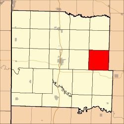 Location in Bates County | |
| Coordinates: 38°15′18″N 94°07′53″W / 38.25500°N 94.13139°WCoordinates: 38°15′18″N 94°07′53″W / 38.25500°N 94.13139°W | |
| Country |
|
| State |
|
| County | Bates |
| Area | |
| • Total | 35.92 sq mi (93.03 km2) |
| • Land | 35.91 sq mi (93 km2) |
| • Water | 0.01 sq mi (0.03 km2) 0.03% |
| Elevation | 902 ft (275 m) |
| Population (2000) | |
| • Total | 247 |
| • Density | 6.9/sq mi (2.7/km2) |
| Time zone | CST (UTC-6) |
| • Summer (DST) | CDT (UTC-5) |
| ZIP codes | 64730, 64770 |
| GNIS feature ID | 0766290 |
Deepwater Township is one of twenty-four townships in Bates County, Missouri, USA. As of the 2000 census, its population was 247.[1]
Deepwater Township took its name from a nearby creek.[2]
Geography
According to the United States Census Bureau, Deepwater Township covers an area of 35.92 square miles (93.03 square kilometers); of this, 35.91 square miles (93 square kilometers, 99.97 percent) is land and 0.01 square miles (0.03 square kilometers, 0.03 percent) is water.
Unincorporated towns
(This list is based on USGS data and may include former settlements.)
Adjacent townships
- Spruce Township (north)
- Walker Township, Henry County (northeast)
- Hudson Township (south)
- Pleasant Gap Township (southwest)
- Summit Township (west)
- Shawnee Township (northwest)
Cemeteries
The township contains these four cemeteries: Radford, Smith, Snodgrass Union and White.
School districts
- Ballard R-II
Political districts
- Missouri's 4th congressional district
- State House District 120
- State Senate District 31
References
- United States Census Bureau 2008 TIGER/Line Shapefiles
- United States Board on Geographic Names (GNIS)
- United States National Atlas
- ↑ United States Census Bureau American FactFinder
- ↑ "Bates County Place Names, 1928-1945 (archived)". The State Historical Society of Missouri. Retrieved 1 September 2016.
External links
 |
Shawnee Township | Spruce Township | Walker Township, Henry County | |
| Summit Township | |
|||
| ||||
| | ||||
| Pleasant Gap Township | Hudson Township |
Municipalities and communities of Bates County, Missouri, United States | ||
|---|---|---|
| Cities | 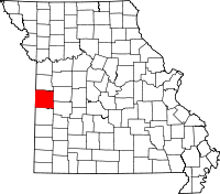 | |
| Villages | ||
| Townships | ||
| Unincorporated communities | ||
| Ghost towns | ||
| Footnotes | ‡This populated place also has portions in an adjacent county or counties | |
This article is issued from Wikipedia - version of the 9/1/2016. The text is available under the Creative Commons Attribution/Share Alike but additional terms may apply for the media files.