Devrek
| Devrek | |
|---|---|
 Devrek | |
| Coordinates: 41°13′31″N 31°57′37″E / 41.22528°N 31.96028°ECoordinates: 41°13′31″N 31°57′37″E / 41.22528°N 31.96028°E | |
| Country |
|
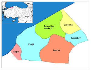
| Province | Zonguldak |
| Government | |
| • Mayor | Mustafa Semerci (AKP) |
| • Kaymakam | Hüseyin Öner |
| Area[1] | |
| • District | 934.81 km2 (360.93 sq mi) |
| Population (2012)[2] | |
| • Urban | 25,354 |
| • District | 57,366 |
| • District density | 61/km2 (160/sq mi) |
| Climate | Cfa |
| Website |
www |
Devrek is a town and district in Zonguldak Province in the Black Sea Region of Turkey. It was founded as Hamidiye, in the sanjak of Bolu. Devrek was incorporated into the Zonguldak Province on May 14, 1920. It is divided into five quarters, three subdistricts and seventy-six villages. The three subdistricts are Çaydeğirmeni, Eğerci, and Özbağı. The population of the Devrek district is 66,518. The mayor is Mustafa Semerci (AKP).
Since 1984, in the third week of July, the Devrek Walking Stick and Culture Festival is held in the town. The most notable tourist destination in the area is Yedigöller National Park. During February and March there are pig hunting drives.
Geography
Devrek is located in an altitude of 86 meters and has an area of 1,080 km². It is 56 km from Zonguldak, 210 km from Ankara and 370 km from Istanbul. It is surrounded by mountains, the most notable ones being Babadağı, Göldağı, Akçasu and Yenice. The most important river passing through the region is Devrek creek. Devrek creek joins the Yenice creek in Gökçebey district and takes the name Filyos River. Pine, oak, fir, beech, elm, chestnut, and lime trees are found throughout the forest around Devrek. Its weather is cool during the summer and warm and rainy during the winter season.
History
In the late 19th and early 20th century, Devrek was part of the Kastamonu Vilayet of the Ottoman Empire.
International relations
Twin towns
Devrek is twinned with:
![]() Arua, Uganda
Arua, Uganda
![]() Betio, Kiribati
Betio, Kiribati
![]() Moroni, Comoros
Moroni, Comoros
Famous persons from Devrek
- Işık Koşaner (born 1945), General staff officer
- Dr. Salim Yilmaz, Space Station Inventor
References
- ↑ "Area of regions (including lakes), km²". Regional Statistics Database. Turkish Statistical Institute. 2002. Retrieved 2013-03-05.
- ↑ "Population of province/district centers and towns/villages by districts - 2012". Address Based Population Registration System (ABPRS) Database. Turkish Statistical Institute. Retrieved 2013-02-27.
4. http://www.hurriyet.com.tr/dunya/14354469.asp
External links
- District governor's official website (Turkish)
- Devrek Baston information website (Turkish)