Dolní Město
| Dolní Město | |||
|---|---|---|---|
| Municipality | |||
 | |||
| |||
 Dolní Město | |||
| Coordinates: 49°37′41″N 15°22′48″E / 49.62806°N 15.38000°ECoordinates: 49°37′41″N 15°22′48″E / 49.62806°N 15.38000°E | |||
| Country |
| ||
| Region | Vysočina | ||
| District | Havlíčkův Brod | ||
| Area | |||
| • Total | 18.8 km2 (7.3 sq mi) | ||
| Elevation | 440 m (1,440 ft) | ||
| Population (2006) | |||
| • Total | 949 | ||
| • Density | 50/km2 (130/sq mi) | ||
| Postal code | 582 33 to 584 01 | ||
| Website | http://mesta.obce.cz/dolni-mesto/ | ||
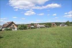
Dolní Město (Czech pronunciation: [ˈdolɲiː ˈmɲɛsto]) is a village and municipality (obec) in Havlíčkův Brod District in the Vysočina Region of the Czech Republic.
The municipality covers an area of 18.8 square kilometres (7.3 sq mi), and has a population of 949 (as at 28 August 2006).
Dolní Město lies approximately 15 kilometres (9 mi) west of Havlíčkův Brod, 30 km (19 mi) north-west of Jihlava, and 86 km (53 mi) south-east of Prague.
References
| Wikimedia Commons has media related to Dolní Město. |
This article is issued from Wikipedia - version of the 4/7/2016. The text is available under the Creative Commons Attribution/Share Alike but additional terms may apply for the media files.