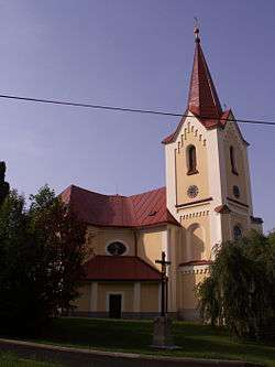
Nová Ves u Chotěboře
| Nová Ves u Chotěboře | |||
|---|---|---|---|
| Municipality | |||
 | |||
| |||
 Nová Ves u Chotěboře | |||
| Coordinates: 49°44′58″N 15°38′45″E / 49.74944°N 15.64583°ECoordinates: 49°44′58″N 15°38′45″E / 49.74944°N 15.64583°E | |||
| Country |
| ||
| Region | Vysočina | ||
| District | Havlíčkův Brod | ||
| Area | |||
| • Total | 12.42 km2 (4.80 sq mi) | ||
| Elevation | 404 m (1,325 ft) | ||
| Population (1.1.2004) | |||
| • Total | 574 | ||
| • Density | 46/km2 (120/sq mi) | ||
| Postal code | 582 73 to 583 01 | ||
| Website | http://www.novavesuchot.cz | ||

Nová Ves u Chotěboře is a village and municipality (obec) in Havlíčkův Brod District in the Vysočina Region of the Czech Republic.
The municipality covers an area of 12.42 square kilometres (4.80 sq mi), and has a population of 572 (as at 28 August 2006).
Nová Ves u Chotěboře lies approximately 17 kilometres (11 mi) north of Havlíčkův Brod, 40 km (25 mi) north of Jihlava, and 96 km (60 mi) south-east of Prague.
References
| Wikimedia Commons has media related to Nová Ves u Chotěboře. |
This article is issued from Wikipedia - version of the 4/7/2016. The text is available under the Creative Commons Attribution/Share Alike but additional terms may apply for the media files.