East Rochester, Pennsylvania
| East Rochester, Pennsylvania | |
|---|---|
| Borough | |
|
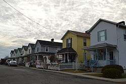
Houses on Foster Avenue | |
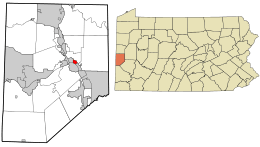 Location in Beaver County and state of Pennsylvania | |
| Coordinates: 40°41′53″N 80°16′05″W / 40.69806°N 80.26806°WCoordinates: 40°41′53″N 80°16′05″W / 40.69806°N 80.26806°W | |
| Country | United States |
| State | Pennsylvania |
| County | Beaver |
| Settled | 1888 |
| Incorporated | 1908 |
| Government | |
| • Type | Borough Council |
| Area | |
| • Total | 0.5 sq mi (1 km2) |
| Elevation | 810 ft (250 m) |
| Population (2010) | |
| • Total | 567 |
| • Density | 1,568.3/sq mi (605.5/km2) |
| Time zone | Eastern (EST) (UTC-5) |
| • Summer (DST) | EDT (UTC-4) |
| Area code(s) | 724 |
East Rochester is a borough in Beaver County, Pennsylvania, along the Ohio River. The population was 567 at the 2010 census.
Geography
East Rochester is located at 40°41′53″N 80°16′5″W / 40.69806°N 80.26806°W (40.698166, -80.268032).[1]
According to the United States Census Bureau, the borough has a total area of 0.5 square miles (1.3 km2), of which, 0.4 square miles (1.0 km2) of it is land and 0.1 square miles (0.26 km2) of it (14.89%) is water.
Demographics
| Historical population | |||
|---|---|---|---|
| Census | Pop. | %± | |
| 1910 | 718 | — | |
| 1920 | 720 | 0.3% | |
| 1930 | 715 | −0.7% | |
| 1940 | 706 | −1.3% | |
| 1950 | 985 | 39.5% | |
| 1960 | 1,025 | 4.1% | |
| 1970 | 920 | −10.2% | |
| 1980 | 789 | −14.2% | |
| 1990 | 672 | −14.8% | |
| 2000 | 623 | −7.3% | |
| 2010 | 567 | −9.0% | |
| Est. 2015 | 550 | [2] | −3.0% |
| Sources:[3][4][5] | |||
As of the census[4] of 2000, there were 623 people, 283 households, and 179 families residing in the borough. The population density was 1,568.3 people per square mile (601.4/km²). There were 293 housing units at an average density of 737.6 per square mile (282.8/km²). The racial makeup of the borough was 95.83% White, 3.53% African American, and 0.64% from two or more races. Hispanic or Latino of any race were 0.16% of the population.
There were 283 households, out of which 22.3% had children under the age of 18 living with them, 46.6% were married couples living together, 11.3% had a female householder with no husband present, and 36.7% were non-families. 33.9% of all households were made up of individuals, and 18.7% had someone living alone who was 65 years of age or older. The average household size was 2.20 and the average family size was 2.81.
In the borough the population was spread out, with 20.1% under the age of 18, 6.7% from 18 to 24, 22.8% from 25 to 44, 25.2% from 45 to 64, and 25.2% who were 65 years of age or older. The median age was 46 years. For every 100 females there were 88.8 males. For every 100 females age 18 and over, there were 79.8 males.
The median income for a household in the borough was $25,625, and the median income for a family was $35,481. Males had a median income of $30,000 versus $25,313 for females. The per capita income for the borough was $14,465. About 8.2% of families and 9.8% of the population were below the poverty line, including 2.5% of those under age 18 and 12.7% of those age 65 or over.
See also
References
- ↑ "US Gazetteer files: 2010, 2000, and 1990". United States Census Bureau. 2011-02-12. Retrieved 2011-04-23.
- ↑ "Annual Estimates of the Resident Population for Incorporated Places: April 1, 2010 to July 1, 2015". Retrieved July 2, 2016.
- ↑ "Census of Population and Housing". U.S. Census Bureau. Retrieved 11 December 2013.
- 1 2 "American FactFinder". United States Census Bureau. Retrieved 2008-01-31.
- ↑ "Incorporated Places and Minor Civil Divisions Datasets: Subcounty Resident Population Estimates: April 1, 2010 to July 1, 2012". Population Estimates. U.S. Census Bureau. Retrieved 11 December 2013.
| Counties | 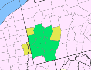 Map of the Pittsburgh Tri-State with green counties in the metropolitan area and yellow counties in the combined area. | |
|---|---|---|
| Major cities | ||
| Cities and towns 15k-50k (in 2010) | ||
| Airports | ||
| Topics | ||
| ||
Municipalities and communities of Beaver County, Pennsylvania, United States | ||
|---|---|---|
| Cities | 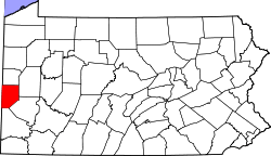 | |
| Boroughs |
| |
| Townships | ||
| Unincorporated communities | ||
| Footnotes | ‡This populated place also has portions in an adjacent county or counties | |