Hanover Township, Beaver County, Pennsylvania
| Hanover Township, Beaver County, Pennsylvania | |
|---|---|
| Township | |
|
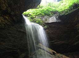
Waterfall in Raccoon Creek State Park | |
 Location in Beaver County and state of Pennsylvania | |
| Country | United States |
| State | Pennsylvania |
| County | Beaver |
| Settled | 1772 |
| Incorporated | 1786 |
| Area | |
| • Total | 45.0 sq mi (116.6 km2) |
| • Land | 44.9 sq mi (116.2 km2) |
| • Water | 0.2 sq mi (0.4 km2) |
| Population (2010) | |
| • Total | 3,690 |
| • Density | 82/sq mi (31.7/km2) |
| Time zone | Eastern (EST) (UTC-5) |
| • Summer (DST) | EDT (UTC-4) |
| Website |
hanovertwpbeaver |
Hanover Township is a township in Beaver County, Pennsylvania, United States. The population was 3,690 at the 2010 census.[1]
History
Two historic sites in Hanover Township are listed on the National Register of Historic Places: the David Littell House, a nineteenth-century farmhouse,[2] and the Recreational Demonstration Area part of Raccoon Creek State Park, which was built by the Civilian Conservation Corps during the Great Depression.[3]
Geography
Hanover Township is located in southern Beaver County, Pennsylvania. It is bordered to the north by Greene Township and Raccoon Township, to the east by Independence Township, to the south by Hanover Township in Washington County, Pennsylvania, and to the west by Hancock County, West Virginia. The borough of Frankfort Springs, while separate from the township, is located along its southern border.
Raccoon Creek State Park occupies 7,500 acres (30 km2) in the center of the township around the valley of Traverse Creek, a tributary of Raccoon Creek.
According to the United States Census Bureau, Hanover Township has a total area of 45.0 square miles (116.6 km2), of which 44.9 square miles (116.2 km2) is land and 0.15 square miles (0.4 km2), or 0.34%, is water.[1]
Demographics
As of the census[4] of 2000, there were 3,529 people, 1,288 households, and 1,025 families residing in the township. The population density was 78.7 people per square mile (30.4/km²). There were 1,413 housing units at an average density of 31.5/sq mi (12.2/km²). The racial makeup of the township was 98.30% White, 0.60% African American, 0.20% Native American, 0.14% Asian, 0.20% from other races, and 0.57% from two or more races. Hispanic or Latino of any race were 0.99% of the population.
There were 1,288 households, out of which 35.5% had children under the age of 18 living with them, 70.0% were married couples living together, 6.7% had a female householder with no husband present, and 20.4% were non-families. 17.9% of all households were made up of individuals, and 6.8% had someone living alone who was 65 years of age or older. The average household size was 2.74 and the average family size was 3.11.
In the township the population was spread out, with 25.6% under the age of 18, 7.2% from 18 to 24, 30.5% from 25 to 44, 26.6% from 45 to 64, and 10.1% who were 65 years of age or older. The median age was 38 years. For every 100 females there were 100.9 males. For every 100 females age 18 and over, there were 99.8 males.
The median income for a household in the township was $44,393, and the median income for a family was $51,000. Males had a median income of $40,544 versus $24,770 for females. The per capita income for the township was $18,079. About 2.5% of families and 3.7% of the population were below the poverty line, including 5.8% of those under age 18 and 3.1% of those age 65 or over.
References
- 1 2 "Geographic Identifiers: 2010 Demographic Profile Data (G001): Hanover township, Beaver County, Pennsylvania". U.S. Census Bureau, American Factfinder. Retrieved February 27, 2014.
- ↑ Schmidlapp, Christina. National Register of Historic Places Inventory/Nomination: David Littell House. National Park Service, 1986-07-11. Accessed 2009-10-29.
- ↑ Milner, John, Associates. National Register of Historic Places Inventory/Nomination: Raccoon Creek RDA. National Park Service, October 1986. Accessed 2009-12-17.
- ↑ "American FactFinder". United States Census Bureau. Retrieved 2008-01-31.
External links
Municipalities and communities of Beaver County, Pennsylvania, United States | ||
|---|---|---|
| Cities | 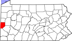 | |
| Boroughs |
| |
| Townships | ||
| Unincorporated communities | ||
| Footnotes | ‡This populated place also has portions in an adjacent county or counties | |
| Counties |  Map of the Pittsburgh Tri-State with green counties in the metropolitan area and yellow counties in the combined area. | |
|---|---|---|
| Major cities | ||
| Cities and towns 15k-50k (in 2010) | ||
| Airports | ||
| Topics | ||
| ||
Coordinates: 40°29′30″N 80°21′59″W / 40.49167°N 80.36639°W