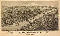
Elizabeth, Pennsylvania
| Elizabeth | |
|---|---|
| Borough | |
|
Second Avenue | |
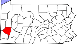
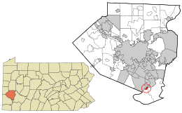 Location in Allegheny County and the state of Pennsylvania | |
| Coordinates: 40°16′16″N 79°53′11″W / 40.27111°N 79.88639°WCoordinates: 40°16′16″N 79°53′11″W / 40.27111°N 79.88639°W | |
| Country | United States |
| State | Pennsylvania |
| County | Allegheny |
| Area | |
| • Total | 0.4 sq mi (1 km2) |
| • Land | 0.3 sq mi (0.8 km2) |
| • Water | 0.1 sq mi (0.3 km2) |
| Population (2010) | |
| • Total | 1,493 |
| • Density | 3,700/sq mi (1,400/km2) |
| Time zone | Eastern (EST) (UTC-5) |
| • Summer (DST) | EDT (UTC-4) |
| ZIP codes | 15088 |
| Area code(s) | 412 |
| Designated | December 20, 1946[1] |

Elizabeth is a borough in Allegheny County, Pennsylvania, on the east bank of the Monongahela River, where Pennsylvania Route 51 crosses, 15 miles (24 km) upstream (south) of Pittsburgh and close to the county line. The population was 1,493 at the 2010 census.[2] The borough of Elizabeth is entirely contained within the 15037 USPS ZIP code. The local school district is the Elizabeth Forward School District.
Geography
Elizabeth is located at 40°16′16″N 79°53′11″W / 40.27111°N 79.88639°W (40.271189, -79.886347).[3]
According to the United States Census Bureau, the borough has a total area of 0.4 square miles (1.0 km2), of which 0.3 square miles (0.78 km2) is land and 0.1 square miles (0.26 km2), or 14.63%, is water.
Demographics
| Historical population | |||
|---|---|---|---|
| Census | Pop. | %± | |
| 1850 | 1,120 | — | |
| 1860 | 975 | −12.9% | |
| 1870 | 1,196 | 22.7% | |
| 1880 | 1,810 | 51.3% | |
| 1890 | 1,804 | −0.3% | |
| 1900 | 1,866 | 3.4% | |
| 1910 | 2,311 | 23.8% | |
| 1920 | 2,703 | 17.0% | |
| 1930 | 2,939 | 8.7% | |
| 1940 | 2,976 | 1.3% | |
| 1950 | 2,615 | −12.1% | |
| 1960 | 2,597 | −0.7% | |
| 1970 | 2,273 | −12.5% | |
| 1980 | 1,892 | −16.8% | |
| 1990 | 1,610 | −14.9% | |
| 2000 | 1,609 | −0.1% | |
| 2010 | 1,493 | −7.2% | |
| Est. 2015 | 1,499 | [4] | 0.4% |
| Sources:[5][6][7][8][9][10][11][12] | |||
As of the census[11] of 2000, there were 1,609 people, 681 households, and 422 families residing in the borough. The population density was 4,544.8 people per square mile (1,775.0/km²). There were 758 housing units at an average density of 2,141.1 per square mile (836.2/km²). The racial makeup of the borough was 94.84% White, 3.60% African American, 0.37% Native American, 0.19% Asian, and 0.99% from two or more races. Hispanic or Latino of any race were 0.25% of the population.
Households: There were 681 households, out of which 26.9% had children under the age of 18 living with them, 44.6% were married couples living together, 11.9% had a female householder with no husband present, and 37.9% were non-families. 33.0% of all households were made up of individuals, and 17.8% had someone living alone who was 65 years or older. The average household size was 2.34 and the average family size was 2.98.
Age Distribution: The population was spread out, with 22.9% under the age of 18, 6.5% from 18 to 24, 28.5% from 25 to 44, 21.0% from 45 to 64, and 21.1% who were 65 or older. The median age was 40. For every 100 females, there were 82.2 males; for every 100 females age 18 and over, there were 79.1 males.
Income: The median income for a household in the borough was $30,556, and the median income for a family was $36,607. Males had a median income of $28,088 versus $22,350 for females. The per capita income for the borough was $17,618. About 7.3% of families and 10.2% of the population were below the poverty line, including 17.5% of those under age 18 and 8.8% of those age 65 or over.
History
- 1787 - Elizabeth (formerly Elizabeth Town) was founded by Samuel Mackay, Colonel Stephen Bayard and his wife Elizabeth Mackay Bayard (for whom the town was named).
- 1788 - Elizabeth was one of the first seven townships organized by Allegheny County; the others being Moon, St. Clair, Mifflin, Versailles, Plum, and Pitt. The original Elizabeth Township comprised the entire triangle of land between the Monongahela and Youghiogheny Rivers. In addition to present-day Elizabeth Borough and Elizabeth Township, this also included areas which are now Forward Township, Lincoln Borough, Port Vue Borough, Liberty Borough, the City of Glassport, and the Tenth Ward of the City of McKeesport.
- 1803 - The keelboat used for the first stages of the Lewis and Clark Expedition was built in Elizabeth. (This claim is disputed by the city of Pittsburgh, which makes a similar claim. See references below.)
- 1834 - On April 2, 1834, a charter was issued to incorporate the Town of Elizabeth as a borough.
- 1869 - Forward Township and Lincoln Township were separated from Elizabeth Township.
Early industry
Among the earliest industries of Elizabeth were glass making, safe making, steamboat building, and ship building. The town had two coal inclines in 1876, the O'Neil and Company Coal Incline on pool 1, and the Lobb's Run Incline on pool 2.
Nike missile site
From 1956 to 1963, Elizabeth was the location of a Nike anti-aircraft missile site (40°15′17″N 79°57′59″W / 40.25472°N 79.96639°W).
References
- ↑ "PHMC Historical Markers Search" (Searchable database). Pennsylvania Historical and Museum Commission. Commonwealth of Pennsylvania. Retrieved 2014-01-25.
- ↑ "Race, Hispanic or Latino, Age, and Housing Occupancy: 2010 Census Redistricting Data (Public Law 94-171) Summary File (QT-PL), Elizabeth borough, Pennsylvania". U.S. Census Bureau, American FactFinder 2. Retrieved September 19, 2011.
- ↑ "US Gazetteer files: 2010, 2000, and 1990". United States Census Bureau. 2011-02-12. Retrieved 2011-04-23.
- ↑ "Annual Estimates of the Resident Population for Incorporated Places: April 1, 2010 to July 1, 2015". Retrieved July 2, 2016.
- ↑ "Population of Civil Divisions Less than Counties" (PDF). 1850 U.S. Census. U.S. Census Bureau. Retrieved 24 November 2013.
- ↑ "Population of Civil Divisions Less than Counties" (PDF). 1880 United States Census. U.S. Census Bureau. Retrieved 24 November 2013.
- ↑ "Population-Pennsylvania" (PDF). U.S. Census 1910. U.S. Census Bureau. Retrieved 22 November 2013.
- ↑ "Number and Distribution of Inhabitants:Pennsylvania-Tennessee" (PDF). Fifteenth Census. U.S. Census Bureau.
- ↑ "Number of Inhabitants: Pennsylvania" (PDF). 18th Census of the United States. U.S. Census Bureau. Retrieved 22 November 2013.
- ↑ "Pennsylvania: Population and Housing Unit Counts" (PDF). U.S. Census Bureau. Retrieved 22 November 2013.
- 1 2 "American FactFinder". United States Census Bureau. Retrieved 2008-01-31.
- ↑ "Annual Estimates of the Resident Population". U.S. Census Bureau. Retrieved 22 November 2013.
Further reading
- Wiley, Richard T. (1936). Elizabeth and Her Neighbors. Butler, Pennsylvania: The Ziegler Company.
External links
- Lewis and Clark timeline from the United States National Park Service
- The Elizabeth Borough official website
| Counties | 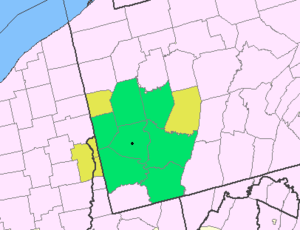 Map of the Pittsburgh Tri-State with green counties in the metropolitan area and yellow counties in the combined area. | |
|---|---|---|
| Major cities | ||
| Cities and towns 15k-50k (in 2010) | ||
| Airports | ||
| Topics | ||
| ||