Etna, Pennsylvania
| Etna | |
| Borough | |
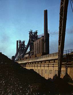 Carnegie-Illinois steel mill | |
| Country | United States |
|---|---|
| State | Pennsylvania |
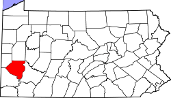
| County | Allegheny County |
| Coordinates | 40°30′1″N 79°56′56″W / 40.50028°N 79.94889°WCoordinates: 40°30′1″N 79°56′56″W / 40.50028°N 79.94889°W |
| Population | 3,451 (2010) |
| Timezone | EST (UTC-5) |
| - summer (DST) | EDT (UTC-4) |
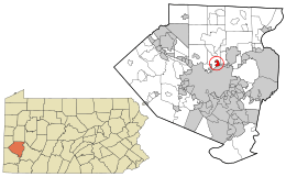 Location in Allegheny County and the state of Pennsylvania | |
 Location of Pennsylvania in the United States | |
| Website: Borough of Etna | |
Etna is a borough in Allegheny County in the U.S. state of Pennsylvania, along the Allegheny River, opposite Pittsburgh. Etna was named after the volcano Mount Etna,[1] an allusion to blast furnaces, steel mills, galvanized-pipe works, and other manufacturers located there. In 1900, 5,384 people lived in Etna. In 1910, 5,830 lived there, and in 1940, 7,223 lived there. The population was 3,451 at the 2010 census.[2]
History
Etna was the terminus of the No. 2 Pittsburgh Railways streetcar service from downtown Pittsburgh, closed in 1952.[3] From 1907 until 1931, it was a stop on the interurban Pittsburgh and Butler Street Railway, which linked Pittsburgh with Butler.
Geography
Etna is located at 40°30′1″N 79°56′56″W / 40.50028°N 79.94889°W (40.500338, -79.948755).[4]
According to the United States Census Bureau, the borough has a total area of 0.8 square miles (2.1 km2), all of it land.
Surrounding communities
Etna is situated on the north bank of the Allegheny River. It is bordered by Shaler Township to the west and north, by Sharpsburg to the east, and by Pittsburgh across the river to the south. Millvale is to the southwest, separated from Etna by part of Shaler Township.
Demographics
| Historical population | |||
|---|---|---|---|
| Census | Pop. | %± | |
| 1870 | 1,447 | — | |
| 1880 | 2,334 | 61.3% | |
| 1890 | 3,707 | 58.8% | |
| 1900 | 5,384 | 45.2% | |
| 1910 | 5,830 | 8.3% | |
| 1920 | 6,341 | 8.8% | |
| 1930 | 7,493 | 18.2% | |
| 1940 | 7,223 | −3.6% | |
| 1950 | 6,750 | −6.5% | |
| 1960 | 5,519 | −18.2% | |
| 1970 | 5,819 | 5.4% | |
| 1980 | 4,534 | −22.1% | |
| 1990 | 4,200 | −7.4% | |
| 2000 | 3,924 | −6.6% | |
| 2010 | 3,451 | −12.1% | |
| Est. 2015 | 3,401 | [5] | −1.4% |
| Sources:[6][7][8][9][10][11][12] | |||
As of the census[11] of 2000, there were 3,924 people, 1,749 households, and 981 families residing in the borough. The population density was 5,254.8 people per square mile (2,020.1/km²). There were 1,934 housing units at an average density of 2,589.9 per square mile (995.6/km²). The racial makeup of the borough was 97.78% White, 0.76% African American, 0.36% Native American, 0.15% Asian, 0.15% from other races, and 0.79% from two or more races. Hispanic or Latino of any race were 1.15% of the population.
There were 1,749 households, out of which 26.6% had children under the age of 18 living with them, 38.2% were married couples living together, 13.7% had a female householder with no husband present, and 43.9% were non-families. 38.5% of all households were made up of individuals, and 15.8% had someone living alone who was 65 years of age or older. The average household size was 2.22 and the average family size was 3.01.
In the borough the population was spread out, with 22.6% under the age of 18, 8.0% from 18 to 24, 31.7% from 25 to 44, 20.6% from 45 to 64, and 17.1% who were 65 years of age or older. The median age was 39 years. For every 100 females there were 89.1 males. For every 100 females age 18 and over, there were 84.6 males.
The median income for a household in the borough was $31,529, and the median income for a family was $41,577. Males had a median income of $31,386 versus $23,601 for females. The per capita income for the borough was $17,580. About 7.5% of families and 9.2% of the population were below the poverty line, including 12.0% of those under age 18 and 17.5% of those age 65 or over.
See also
References
- ↑ "What's in a name? For some, a bit of history". Pittsburgh Post-Gazette. May 10, 1984. p. 2. Retrieved 16 May 2015.
- ↑ "Race, Hispanic or Latino, Age, and Housing Occupancy: 2010 Census Redistricting Data (Public Law 94-171) Summary File (QT-PL), Etna borough, Pennsylvania". U.S. Census Bureau, American FactFinder 2. Archived from the original on September 11, 2013. Retrieved September 19, 2011.
- ↑ "Pittsburghtransit.com - The Routes - PCC Operation". August 28, 2005. Archived from the original on August 28, 2005. Retrieved August 9, 2009.
- ↑ "US Gazetteer files: 2010, 2000, and 1990". United States Census Bureau. 2011-02-12. Retrieved 2011-04-23.
- ↑ "Annual Estimates of the Resident Population for Incorporated Places: April 1, 2010 to July 1, 2015". Retrieved July 2, 2016.
- ↑ "Population of Civil Divisions Less than Counties" (PDF). 1880 United States Census. U.S. Census Bureau. Retrieved 24 November 2013.
- ↑ "Population-Pennsylvania" (PDF). U.S. Census 1910. U.S. Census Bureau. Retrieved 22 November 2013.
- ↑ "Number and Distribution of Inhabitants:Pennsylvania-Tennessee" (PDF). Fifteenth Census. U.S. Census Bureau.
- ↑ "Number of Inhabitants: Pennsylvania" (PDF). 18th Census of the United States. U.S. Census Bureau. Retrieved 22 November 2013.
- ↑ "Pennsylvania: Population and Housing Unit Counts" (PDF). U.S. Census Bureau. Retrieved 22 November 2013.
- 1 2 "American FactFinder". United States Census Bureau. Archived from the original on September 11, 2013. Retrieved 2008-01-31.
- ↑ "Annual Estimates of the Resident Population". U.S. Census Bureau. Retrieved 22 November 2013.
External links
| Counties |  Map of the Pittsburgh Tri-State with green counties in the metropolitan area and yellow counties in the combined area. | |
|---|---|---|
| Major cities | ||
| Cities and towns 15k-50k (in 2010) | ||
| Airports | ||
| Topics | ||
| ||