Frankfort (town), New York
| Frankfort | |
|---|---|
| Town | |
|
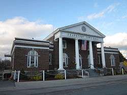
Town Hall | |
 Frankfort Location of Frankfort in New York | |
| Coordinates: 43°02′20″N 75°04′14″W / 43.03889°N 75.07056°WCoordinates: 43°02′20″N 75°04′14″W / 43.03889°N 75.07056°W | |
| Country | United States |
| State | New York |
| County | Herkimer |
| Government | |
| • Type | Town Council |
| • Town Supervisor | Joseph P. Kinney (R) |
| • Town Council |
Members' List
|
| Population (2010) | |
| • Total | 7,636 |
| Website |
www |
Frankfort is a town in Herkimer County, New York, United States. The town is named after one of its earliest settlers, Lawrence (Lewis) Frank.[1] The town of Frankfort includes a village, also called Frankfort. Frankfort is located east of Utica and the Erie Canal passes along its north border. At the time of the 2010 census, the population was 7,636.[2] The current mayor of the town is Frank M. Morocco.[3]
Frankfort is also home to the Great American Irish Festival, one of the fastest growing Irish Festivals in America, which is held within the Herkimer County Fairgrounds.
History
The first European settlers in this area were German Palatines who came to the colony as religious refugees in 1723. During the French and Indian War, this area suffered fierce attacks by the French with their Indian allies, and the settlers abandoned much of the area. The area of the early town was resettled before 1794, by the granting of land patents.
After the American Revolutionary War, the town of Frankfort was established from part of German Flatts. In 1798, the northwest part of Frankfort was taken away to form part of the town of Deerfield.
The Balloon Farm in Frankfort was listed on the National Register of Historic Places in 1998.[4]
Geography
According to the United States Census Bureau, Frankfort has an area of 37.3 square miles (96.7 km²), of which 37.2 square miles (96.4 km²) is land and 0.1 square miles (0.3 km²) is water.
The western border of the town is the Oneida County line and the northern border is the Mohawk River. Moyer Creek and Ferguson Creek flow northward through Frankfort to the Mohawk River.
New York State Route 5S runs parallel to the Mohawk River. New York State Route 171 intersects NY 5S in the village of Frankfort.
Demographics
| Historical population | |||
|---|---|---|---|
| Census | Pop. | %± | |
| 1820 | 1,860 | — | |
| 1830 | 2,620 | 40.9% | |
| 1840 | 3,096 | 18.2% | |
| 1850 | 3,023 | −2.4% | |
| 1860 | 3,247 | 7.4% | |
| 1870 | 3,065 | −5.6% | |
| 1880 | 3,025 | −1.3% | |
| 1890 | 3,988 | 31.8% | |
| 1900 | 4,472 | 12.1% | |
| 1910 | 5,105 | 14.2% | |
| 1920 | 6,483 | 27.0% | |
| 1930 | 6,918 | 6.7% | |
| 1940 | 6,247 | −9.7% | |
| 1950 | 6,598 | 5.6% | |
| 1960 | 7,550 | 14.4% | |
| 1970 | 7,805 | 3.4% | |
| 1980 | 7,686 | −1.5% | |
| 1990 | 7,494 | −2.5% | |
| 2000 | 7,463 | −0.4% | |
| 2010 | 7,636 | 2.3% | |
| Est. 2014 | 7,533 | [5] | −1.3% |
As of the 2000 census, there were 7,478 people, 2,997 households, and 2,091 families residing in Frankfort.[2] The population density was 200.9 people per square mile (77.6/km²). There were 3,185 housing units at an average density of 85.6 per square mile (33.0/km²). The racial makeup of the town was 97.93% White, 0.49% African American, 0.13% Native American, 0.13% Asian, 0.16% from other races, and 1.15% from two or more races. Hispanic or Latino of any race were 1.02% of the population.
There were 2,997 households out of which 30.9% had children under the age of 18 living with them, 55.1% were married couples living together, 10.5% had a female householder with no husband present, and 30.2% were non-families. 25.0% of all households were made up of individuals and 14.0% had someone living alone who was 65 years or older. The average household size was 2.49 and the average family size was 2.99.
In the town the population was 23.7% under the age of 18, 7.1% from 18 to 24, 27.7% from 25 to 44, 24.2% from 45 to 64, and 17.3% who were 65 years or older. The median age was 40 years. For every 100 females, there were 91.1 males. For every 100 females age 18 and over, there were 87.8 males.
The median income for a household in the town was $38,399, and the median income for a family was $43,594. Males had a median income of $30,423 versus $22,813 for females. The per capita income for the town was $16,719. About 7.5% of families and 9.2% of the population were below the poverty line, including 12.3% of those under age 18 and 10.3% of those age 65 or over.
Frankfort has a large Italian American population.[7] Many Italian American families in the town and village are descendants of immigrants from Oriolo, Cosenza, or Calabria, Italy. The first settler from Oriolo may have been Giuseppe Franchino who appeared in the 1880 census as Joseph Frank, age 33, birthplace Italy.
Communities and locations in the Town of Frankfort
- Corrado Corners – A hamlet immediately southwest of Frankfort village.
- Dutch Hill – An elevation in the northern part of Frankfort.
- East Frankfort – A hamlet immediately southeast of Frankfort village, located on NY-5S at the east town line. It was previously called "McGowansville." East Frankfort borders the village of Ilion.
- Frankfort – A village in the northeast part of the town, located on NY-5S at the Mohawk River.
- Frankfort Center – A hamlet west of Frankfort village, located on County Road 13. It was previously called "Howards Bush."
- Frankfort Gorge – A valley containing Moyer Creek that extends from the south town line up to Frankfort village.
- Frankfort Hill – A location in the western part of the town, north of Stewart Corners on County Road 104. The Frankfort Hill District No. 10 School was listed on the National Register of Historic Places in 2011.[8]
- Gulph – A hamlet by the south town line on NY-171.
- Harbor – A hamlet in the northwest part of the town, east of West Frankfort on NY-5S by County Road 240.
- Kinney Corners – A location on the south town line on County Road 27. The Remington House was added to the National Register of Historic Places in 1997.[4]
- Maggie's Bush – A former community in the western part of Frankfort.
- North Frankfort – A location north of Frankfort village, near the Mohawk River.
- Stewart Corners – A hamlet in the western part of the town at the junction of County Roads 104 and 186.
- West Frankfort – A hamlet on NY-5S near the west town line in the northwest corner of the town. It was originally called "Four Mile Grocery."
The Herkimer County Fair
The Herkimer County Fair is a six-day fair held annually in Frankfort.[9] The fair was started in 1841 as the Herkimer County Agricultural Society, and traveled from village to village. In the 1900s, the fair was located at a site which later became the Hekimer Thruway interchange. At that time, the fair had a racetrack and grandstand which were later destroyed by a fire. After moving to Frankfort in 1950, the fair became an annual event. In 1958, it moved to a permanent site on Cemetery Hill in Frankfort, after buying the Slocum Farm. The fair currently sits on 26 acres (11 ha), and has 10 permanent buildings as well a permanent bathroom, shower facilities, a horse corral, and aluminum bleacher seating surrounding the event show ring.[10]
Notable people
- Charles A. Budlong, Wisconsin State Assemblyman, was born in Frankfort.[11]
- Hiram Cronk, the last surviving veteran of the War of 1812 at the time of his death, was born in Frankfort.
- Carl Edgar Myers, owned "balloon farm" business with Carlotta, the Lady Aeronaut.[12]
- Rich Talarico, a writer, director, producer and actor known mostly for Comedy Central's Key and Peele, was born in Frankfort.
References
- ↑ Gannett, Henry (1905). The Origin of Certain Place Names in the United States. Govt. Print. Off. p. 131.
- 1 2 "American FactFinder". United States Census Bureau. Retrieved 2008-01-31.
- ↑ "Officials". Village of Frankfort. Retrieved 2016-02-21.
- 1 2 National Park Service (2009-03-13). "National Register Information System". National Register of Historic Places. National Park Service.
- ↑ "Annual Estimates of the Resident Population for Incorporated Places: April 1, 2010 to July 1, 2014". Retrieved June 4, 2015.
- ↑ "Census of Population and Housing". Census.gov. Retrieved June 4, 2015.
- ↑ "Village Of Frankfort: Demographics: Demographics [Digital Towpath]". Village of Frankfort. Retrieved 2015-05-15.
- ↑ "National Register of Historic Places". Weekly List of Actions Taken on Properties: 6/20/11 through 6/24/11. National Park Service. 2011-07-01. Retrieved 14 May 2015.
- ↑ "History of the Fair". The Herkimer County Fair. Herkimer County Fair Association. Retrieved 22 February 2016.
- ↑ "Herkimer County Fair Home". Herkimercountyfair.org.
- ↑ State of Wisconsin Blue Book. Legislative Reference Bureau. 1933. p. 242. OCLC 671789504.
- ↑ Dieffenbacher 2002, p. 104.
Sources
- Dieffenbacher, Jane W. (2002). Herkimer County Valley Towns. Arcadia Publishing. ISBN 978-0-7385-0977-8.
External links
Municipalities and communities of Herkimer County, New York, United States | ||
|---|---|---|
| City | 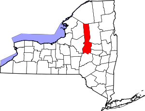 | |
| Towns | ||
| Villages | ||
| CDP | ||
| Hamlets | ||
| Footnotes | ‡This populated place also has portions in an adjacent county or counties | |