Grandview, Missouri
| Grandview, Missouri | |
|---|---|
| City | |
|
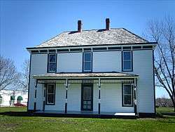
Harry S. Truman Farm Home in Grandview | |
| Nickname(s): G-View / Dreamview | |
 Location of Grandview, Missouri | |
| Coordinates: 38°53′6″N 94°31′21″W / 38.88500°N 94.52250°WCoordinates: 38°53′6″N 94°31′21″W / 38.88500°N 94.52250°W | |
| Country | United States |
| State | Missouri |
| County | Jackson |
| Incorporated | February 6, 1912[1] |
| Government | |
| • Mayor | Leonard Jones |
| Area[2] | |
| • Total | 14.79 sq mi (38.31 km2) |
| • Land | 14.73 sq mi (38.15 km2) |
| • Water | 0.06 sq mi (0.16 km2) |
| Elevation | 1,050 ft (320 m) |
| Population (2010)[3] | |
| • Total | 24,475 |
| • Estimate (2012[4]) | 24,601 |
| • Density | 1,661.6/sq mi (641.5/km2) |
| Time zone | Central (CST) (UTC-6) |
| • Summer (DST) | CDT (UTC-5) |
| ZIP code | 64030 |
| Area code(s) | 816 |
| FIPS code | 29-28324 |
| GNIS feature ID | 0718686[5] |
| Website |
www |
Grandview is a city in Jackson County, Missouri, United States. The population was 24,475 at the 2010 census.
History
A post office called Grandview has been in operation since 1889.[6] The city was named for the view obtained from the elevated town site.[7]
Geography
Grandview is located at 38°53′6″N 94°31′21″W / 38.88500°N 94.52250°W (38.885007, -94.522578),[8] along U.S. Route 71, bordering Kansas City, Missouri, to the south.
According to the United States Census Bureau, the city has a total area of 14.79 square miles (38.31 km2), of which, 14.73 square miles (38.15 km2) is land and 0.06 square miles (0.16 km2) is water.[2]
Demographics
| Historical population | |||
|---|---|---|---|
| Census | Pop. | %± | |
| 1920 | 410 | — | |
| 1930 | 707 | 72.4% | |
| 1940 | 596 | −15.7% | |
| 1950 | 1,556 | 161.1% | |
| 1960 | 6,027 | 287.3% | |
| 1970 | 17,456 | 189.6% | |
| 1980 | 24,502 | 40.4% | |
| 1990 | 24,967 | 1.9% | |
| 2000 | 24,881 | −0.3% | |
| 2010 | 24,475 | −1.6% | |
| Est. 2015 | 25,256 | [9] | 3.2% |
| U.S. Decennial Census[10] 2012 Estimate[11] | |||
The library in Grandview is part of the Mid-Continent Public Library system.
2010 census
As of the census[3] of 2010, there were 24,475 people, 9,640 households, and 6,137 families residing in the city. The population density was 1,661.6 inhabitants per square mile (641.5/km2). There were 11,070 housing units at an average density of 751.5 per square mile (290.2/km2). The racial makeup of the city was 48.4% White (45.0% non-Hispanic white), 40.8% African American, 0.5% Native American, 1.1% Asian, 0.1% Pacific Islander, 5.1% from other races, and 4.0% from two or more races. Hispanic or Latino of any race were 9.7% of the population.
There were 9,640 households of which 34.9% had children under the age of 18 living with them, 38.6% were married couples living together, 19.2% had a female householder with no husband present, 5.9% had a male householder with no wife present, and 36.3% were non-families. 29.8% of all households were made up of individuals and 8.2% had someone living alone who was 65 years of age or older. The average household size was 2.52 and the average family size was 3.12.
The median age in the city was 33.7 years. 26.2% of residents were under the age of 18; 10.2% were between the ages of 18 and 24; 27.7% were from 25 to 44; 24.7% were from 45 to 64; and 11.2% were 65 years of age or older. The gender makeup of the city was 47.6% male and 52.4% female.
2000 census
As of the census of 2000, there were 24,881 people, 9,709 households, and 6,485 families residing in the city. The population density was 1,689.4 people per square mile (652.2/km²). There were 10,348 housing units at an average density of 702.6 per square mile (271.2/km²). The racial makeup of the city was 59.81% White, 33.54% African American, 0.56% Native American, 1.05% Asian, 0.10% Pacific Islander, 1.93% from other races, and 3.00% from two or more races. Hispanic or Latino of any race were 4.33% of the population.
There were 9,709 households out of which 33.3% had children under the age of 18 living with them, 46.3% were married couples living together, 15.9% had a female householder with no husband present, and 33.2% were non-families. 27.5% of all households were made up of individuals and 7.1% had someone living alone who was 65 years of age or older. The average household size was 2.53 and the average family size was 3.08.
In the city the population was spread out with 27.2% under the age of 18, 10.0% from 18 to 24, 31.1% from 25 to 44, 22.0% from 45 to 64, and 9.7% who were 65 years of age or older. The median age was 34 years. For every 100 females there were 93.1 males. For every 100 females age 18 and over, there were 89.7 males.
The median income for a household in the city was $40,003, and the median income for a family was $47,889. Males had a median income of $32,481 versus $26,834 for females. The per capita income for the city was $19,079. About 5.1% of families and 8.4% of the population were below the poverty line, including 11.4% of those under age 18 and 2.4% of those age 65 or over.
Economy
Top employers
According to the town's 2010 Comprehensive Annual Financial Report,[12] the top employers in the city are:
| # | Employer | # of Employees |
|---|---|---|
| 1 | Grandview C-4 School District | 675 |
| 2 | Peterson Manufacturing | 519 |
| 3 | MeadWestvaco | 340 |
| 4 | Sika | 305 |
| 5 | ThyssenKrupp Access | 212 |
| 6 | United Heating & Cooling | 184 |
| 7 | US Toy | 181 |
| 8 | City of Grandview | 176 |
| 9 | Kenny’s | 160 |
| 10 | Triumph Structures - Kansas City | 150 |
Notable people
- Alec Burks, 2011 1st round pick of the Utah Jazz, attended Grandview High School.
- Josh Freeman, Quarterback for the Indianapolis Colts
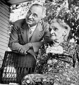
- Harry S. Truman, President of the United States, lived in Grandview for part of his early years.
- Martha Ellen Young Truman, mother of President Harry S. Truman.
References
- ↑ http://grandview.org/Home/Components/News/News/566/559?npage=11&arch=1
- 1 2 "US Gazetteer files 2010". United States Census Bureau. Retrieved 2012-07-08.
- 1 2 "American FactFinder". United States Census Bureau. Retrieved 2012-07-08.
- ↑ "Population Estimates". United States Census Bureau. Retrieved 2013-05-30.
- ↑ "US Board on Geographic Names". United States Geological Survey. 2007-10-25. Retrieved 2008-01-31.
- ↑ "Post Offices". Jim Forte Postal History. Retrieved 16 October 2016.
- ↑ "Jackson County Place Names, 1928–1945 (archived)". The State Historical Society of Missouri. Retrieved 16 October 2016.
- ↑ "US Gazetteer files: 2010, 2000, and 1990". United States Census Bureau. 2011-02-12. Retrieved 2011-04-23.
- ↑ "Annual Estimates of the Resident Population for Incorporated Places: April 1, 2010 to July 1, 2015". Retrieved July 2, 2016.
- ↑ United States Census Bureau. "Census of Population and Housing". Retrieved July 8, 2013.
- ↑ "Annual Estimates of the Resident Population: April 1, 2010 to July 1, 2012". Retrieved July 8, 2013.
- ↑ "Grandview 2010 Comprehensive Annual Financial Report" (PDF). Retrieved March 17, 2011.
External links
Municipalities and communities of Jackson County, Missouri, United States | ||
|---|---|---|
| Cities | 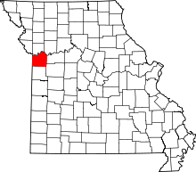 | |
| Villages | ||
| Townships | ||
| Unincorporated communities | ||
| Footnotes | ‡This populated place also has portions in an adjacent county or counties | |
Kansas City metropolitan area's cities and counties | ||
|---|---|---|
| Central city | 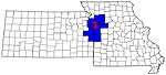 | |
| Largest cities (over 100,000 in 2000) | ||
| Medium-sized cities (10,000 to 100,000 in 2000) | ||
| Smaller Cities (between 5,000 and 9,900 in 2010) | ||
| Counties | ||